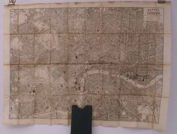
Bacon's New Map of Central London. Divided into Half Mile Squares and Circles. Scale: Four Inches to the Mile. A RARE SURVIVAL
Rare and modern books
Bacon G.W.
Bacon,
1890
Bacon's New Map of Central London. Divided into Half Mile Squares and Circles. Scale: Four Inches to the Mile. A RARE SURVIVAL
Rare and modern books
Bacon G.W.
Bacon,
1890
184.00 €
(Devon,
United Kingdom)
Payment methods
- PayPal
- Credit card
- Bank transfer
- Pubblica amministrazione
- Carta del Docente
Details
- Year of publication
- 1890
- Author
- Bacon G.W.
- Publishers
- Bacon
- Keyword
- topography, london, maps, g.w. bacon, g.w. bacon, topography, maps, bacon's, new, map, central, london
- Languages
- English
Description
Folding engraved map printed on fine ivory linen, size: 21 x 28 ins (approx. 53.0 x 71.0 cms) folding in 36 panels to 6 x 3 ins (approx. 15.o x 7.5 cms), printed surface very lightly browned (rather more heavily so along central fold), a few locations marked with red ink ; original green cloth slip-case framed in blind and lettered in black 'Flexible Map of London' with deckled thumb-hole, a very good, bright copy. Covers the area from Islington (north) to Oval (south); Notting Hill (west) to Stepney (east). IN THIS CONDITION A RARE SURVIVAL. Hyde, 'Printed Maps of Victorian London', no. 201.