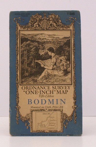
Ordnance Survey 'One-Inch' Map. Fifth Edition. Bodmin. Sheet 136. [Scale: One Inch to One Mile]. BRIGHT, CLEAN COPY OF THE 1936 REVISION
Rare and modern books
Ordnance Survey
Ordnance Survey, Southampton,
1936
Ordnance Survey 'One-Inch' Map. Fifth Edition. Bodmin. Sheet 136. [Scale: One Inch to One Mile]. BRIGHT, CLEAN COPY OF THE 1936 REVISION
Rare and modern books
Ordnance Survey
Ordnance Survey, Southampton,
1936
25.30 €
(Devon,
United Kingdom)
Payment methods
- PayPal
- Credit card
- Bank transfer
- Pubblica amministrazione
- Carta del Docente
Details
- Year of publication
- 1936
- Author
- Ordnance Survey
- Publishers
- Ordnance Survey, Southampton
- Keyword
- topography, cartography, maps, ordnance survey, bodmin
- Languages
- English
Description
Folding coloured map on cloth measuring 29 x 34 ins (approx. 73 x 86 cms) folding in 32 panels to 7.5 x 4.5 ins (approx. 17.7 x 10.1 cms); original pictorial card wrappers, a very good, bright, clean copy. The One-Inch Fifth Edition began publication in 1932; Sheet 136 was first issued in 1933. This is the 1936 revision. The cover is Ellis Martin's 'hiker on hillside' in blue and black with location map. SCARCE IN THIS CONDITION. Browne, 23.2.ab.