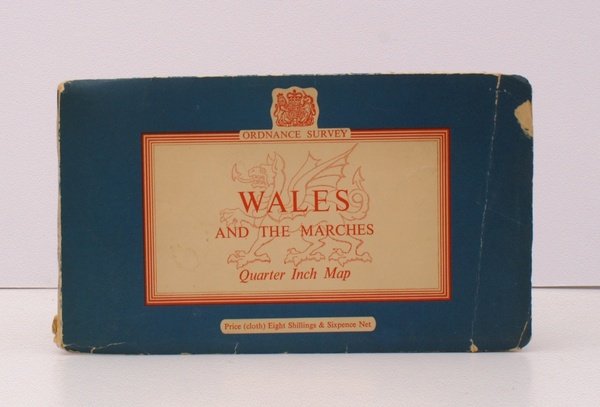
Wales and the Marches. Quarter Inch Map. [Quarter-Inch Fifth Series Special Sheet. Scale: Quarter-Inch to One Mile]. BRIGHT, CLEAN COPY OF THE FIRST ISSUE WITH UNIQUE COVER
Rare and modern books
Ordnance Survey
Ordnance Survey, Chessington,
1959
Wales and the Marches. Quarter Inch Map. [Quarter-Inch Fifth Series Special Sheet. Scale: Quarter-Inch to One Mile]. BRIGHT, CLEAN COPY OF THE FIRST ISSUE WITH UNIQUE COVER
Rare and modern books
Ordnance Survey
Ordnance Survey, Chessington,
1959
43.70 €
(Devon,
United Kingdom)
Payment methods
- PayPal
- Credit card
- Bank transfer
- Pubblica amministrazione
- Carta del Docente
Details
- Year of publication
- 1959
- Author
- Ordnance Survey
- Publishers
- Ordnance Survey, Chessington
- Keyword
- topography, cartography, maps, ordnance survey, wales, welsh marches, stanley phillip reeves
- Languages
- English
Description
Folding coloured map on cloth measuring 41 x 32 ins (approx. 104 x 81 cms) folding in 36 panels to 8.25 x 5.0 ins (approx. 21.0 x 13.0 cms); original pictorial card wrappers, some light dust-soiling, small closed tear in rear wrapper else a very good, bright, clean copy. Fifth Series Special Sheets were produced for a relatively small number of selected regions, and not included in the numbered sheet series. The cover is Reeves' 'Five Lines' in blue landscape format with Welsh Dragon in red. THIS COVER DESIGN IS UNIQUE, AND SCARCE IN THIS CONDITION. Browne, 100.2.