A Chart Describing the Coast of Great Britain and Ireland to the Straits of Gibraltar and the Mediterranean Sea.
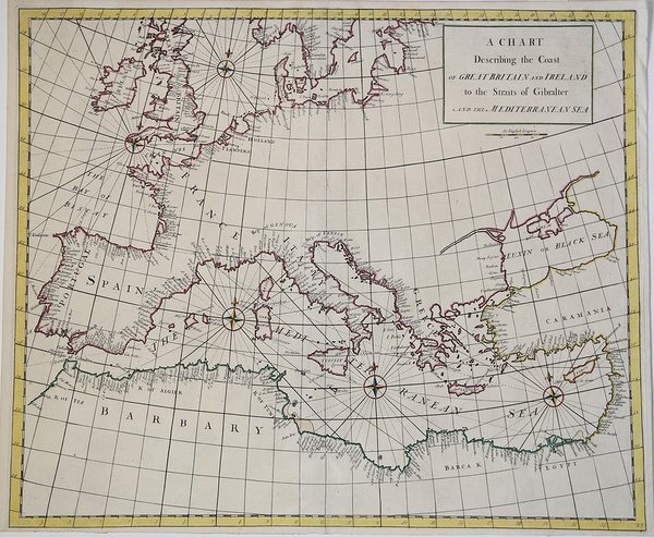
A Chart Describing the Coast of Great Britain and Ireland to the Straits of Gibraltar and the Mediterranean Sea.
Payment methods
- PayPal
- Credit card
- Bank transfer
- Pubblica amministrazione
- Carta del Docente
Details
- Year of publication
- 1728
- Place of printing
- Londra
- Size
- 610 X 550
- Engravers
- SENEX John
- Inscription description
- S. Bifolco, "Mare Nostrum, Cartografia nautica a stampa del Mar Mediterraneo" (2020), p. 215, tav. 98.
Description
Acquaforte, dimensioni 505x610 mm. Bellissimo esemplare, finemente colorato a mano.Opera tratta da: Atlas maritimus & commercialis, or, A general view of the world, so far as relates to trade and navigation: describing all the coasts, ports, harbours, and noted rivers . : to which are added sailing directions for all the known coasts and islands on the globe, with a set of sea charts, some laid down after Mercator, but the greater part according to a new globular projection adapted for measuring distances.by scale and compass.the use of the projection justified by Dr. Halley. To which are subjoin'd two large hemispheres on the plane of the equinoctial containing all the stars in the Britannic catalogue: of great use to sailors for finding the latitude in the night. London: For J. & J. Knapton, W. & J. Innys [Etc.], 1728.Questo lavoro molto raro è nato dalla collaborazione di alcuni dei principali cartografi e scienziati del periodo, tra i quali Sir Edmund Halley, John Senex, Nathaniel Cutler, Steven Parker e Daniel Defoe. L’Atlas maritimus & commercialis venne ideato da Senex e Harris nel tentativo di competere con il popolarissimo The English Pilot di Mount & Page; tuttavia, nonostante la collaborazione fosse di altissimo livello scientifico, l’atlante non ebbe grande successo commerciale. Bibliografia: Mare Nostrum, a historic voyage across the Mediterranean Sea, Lussemburgo, 2003, p. 33; National Maritime Museum, Catalogue of the Library - Vol. Three, Atlas & Cartography, Londra, 1971, pp. 400-401, n. 341(22); R. Shirley, Maps in the Atlases of the British Library, Londra, 2004, pp. 1177-78, M.Hall -1a (22); cfr. The Compleat Plattmaker: essays on Chart, Map and Globe Making in England in the Seventeenth and Eighteenth Centuries, Berkeley, 1978. Etching, with fine later hand colour, very good condition.Taken from: Atlas maritimus & commercialis, or, A general view of the world, so far as relates to trade and navigation: describing all the coasts, ports, harbours, and noted rivers . : to which are added sailing directions for all the known coasts and islands on the globe, with a set of sea charts, some laid down after Mercator, but the greater part according to a new globular projection adapted for measuring distances.by scale and compass.the use of the projection justified by Dr. Halley. To which are subjoin'd two large hemispheres on the plane of the equinoctial containing all the stars in the Britannic catalogue: of great use to sailors for finding the latitude in the night. London: For J. & J. Knapton, W. & J. Innys [Etc.], 1728.This very rare work was born from the collaboration of some of the leading cartographers and scientists of the period, including Sir Edmund Halley, John Senex, Nathaniel Cutler, Steven Parker and Daniel Defoe. The Atlas maritimus & commercialis was designed by Senex and Harris in an attempt to compete with Mount & Page's hugely popular The English Pilot; however, despite the collaboration was of the highest scientific level, the atlas did not have great commercial success.Bibliografia: Mare Nostrum, a historic voyage across the Mediterranean Sea, Lussemburgo, 2003, p. 33; National Maritime Museum, Catalogue of the Library - Vol. Three, Atlas & Cartography, Londra, 1971, pp. 400-401, n. 341(22); R. Shirley, Maps in the Atlases of the British Library, Londra, 2004, pp. 1177-78, M.Hall -1a (22); cfr. The Compleat Plattmaker: essays on Chart, Map and Globe Making in England in the Seventeenth and Eighteenth Centuries, Berkeley, 1978. Cfr. S. Bifolco, "Mare Nostrum, Cartografia nautica a stampa del Mar Mediterraneo" (2020), p. 215, tav. 98.