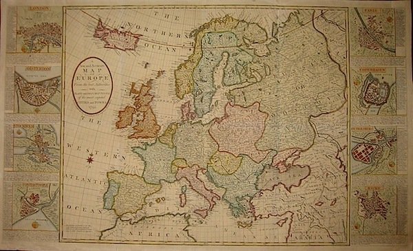
A new and accurate map of Europe from the best Authorities with plans and descriptions of the most capital cities and towns
A new and accurate map of Europe from the best Authorities with plans and descriptions of the most capital cities and towns | Prints | Anonimo
Prints
Anonimo
1795
A new and accurate map of Europe from the best Authorities with plans and descriptions of the most capital cities and towns
A new and accurate map of Europe from the best Authorities with plans and descriptions of the most capital cities and towns | Prints | Anonimo
Prints
Anonimo
1795
3000.00 €
(Roma,
Italy)
Payment methods
- PayPal
- Credit card
- Bank transfer
- Pubblica amministrazione
- Carta del Docente
Details
- Year of publication
- 1795
- Place of printing
- Londra
- Engravers
- Anonimo
Description
Carta geografica originale su due fogli uniti (cm. 102,5x61 più margini bianchi) pubblicata da John Evans. Bella coloritura coeva all’acquerello. Nei riquadri laterali piante delle città di Londra, Amsterdam, Stoccolma, Costantinopoli, Parigi, Copenaghen, San Pietroburgo e Roma. Carta controfondata e alcune tracce di piegature ma, nel complesso, bell’esemplare di questa rara ed affascinante mappa del Vecchio Continente.
