A New Map of the Mediterranean Sea
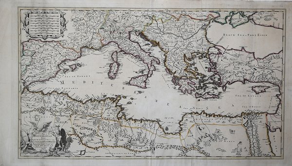
A New Map of the Mediterranean Sea
Payment methods
- PayPal
- Credit card
- Bank transfer
- Pubblica amministrazione
- Carta del Docente
Details
- Year of publication
- 1670
- Place of printing
- Londra
- Size
- 860 X 500
- Engravers
- OVERTON John
Description
Grande carta del Mediterraneo pubblicata nel Overton Atlas, per la prima volta edito nel 1670. La mappa deriva da quella di Guillelme Sanson. John Overton (1640-1713) fu un abile editore che dal 1670 iniziò la revisione e la vendita di carte geografiche provenienti dalla produzione di William Smith, Blaeu, Janssonius, Sanson, Speed ed altri cartografi del passato. Il suo atlante ebbe ben sei stesure, continuamente arricchito di nuove carte, fino all’edizione definitiva pubblicata postuma dal figlio Henry. Incisione in rame, coloritura coeva, in ottimo stato di conservazione. Carta molto rara. Great map of the Mediterranean published in the Overton Atlas, printed for the first time in 1670. The map is inspired to the one of Guillelme Sanson. ,John Overton (1640-1713) was a capable publisher who started, in 1670, the revision and sell of maps coming from the production of William Smith, Blaeu, Janssonius, Sanson, Speed and many others. His atlas has been issued six times, every time enriched with new maps, until the final edition published by his son, Henry. Copperplate, contemporary colour, in excellent condition. Cfr.