Afbeelding van 'T Joodsche Land…

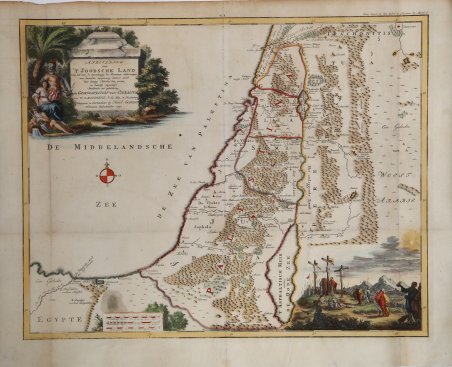
Afbeelding van 'T Joodsche Land…
Payment methods
- PayPal
- Credit card
- Bank transfer
- Pubblica amministrazione
- Carta del Docente
Details
- Year of publication
- 1750
- Place of printing
- Gorinchem
- Size
- 500 X 375
- Engravers
- BACHIENE William Albert
Description
Affascinante mappa che mostra la terra di Israele con tutti i luoghi, fiumi, montagne e mari menzionati nelle Sacre Scritture.La mappa copre tutta la Palestina su entrambi i lati del fiume Giordano e la costa mediterranea da Tyrus a Rhinocolura (El Arish).In basso a destra è rapprentata una scena con Gesù sulla croce, mentre in alto a sinistra il cartiglio decorativo con il titolo.Incisione in rame, bella coloritura, in ottimo stato di conservazione.Incisa da Jan van Jagen e pubblicato in un'edizione olandese della Bibbia da Nicolas Goetzee. This attractive map from a large Dutch Bible shows the land of Israel with all the places, rivers, mountains, and seas mentioned in the Holy Scriptures. It covers all of Palestine on both sides of the Jordan River and the Mediterranean coastline from Tyrus to Rhinocolura (El Arish). At bottom is a scene with Jesus at the cross. Copperplate with fine later hand colour, very good condition.Engraved by Jan van Jagen and published in a Dutch Bible by Nicolas Goetzee. Cfr.