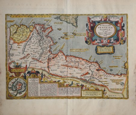
Splendida carta storico-geografica dell'antico regno cartaginese pubblicata nel ' Parergon ' di Abraham Ortelius. Questa carta, attraente e ricca di dettagli, si concentra sull'antico regno cartaginese all'epoca delle guerre puniche. La carta copre la costa nordafricana dall'Algeria alla Libia, concentrandosi sulla Tunisia e sull'arcipelago tra l'Africa e la Sicilia; Malta è mostrata in primo piano. Un inserto planimetrico mostra la città e il porto di Cartagine prima della sua distruzione. Esemplare dalla rara edizione italiana del Theatrum Orbis Terrarum stampata ad Anversa da Jean Baptiste Vrients nel 1608 e quindi nel 1612. Esemplare di primo stato. Titolo: AFRICAE | PROPRIAE | TABVLA, | "In qua", | Punica regna vides;| Tyrios, et Agenoris | urbem. | "Illustri ac Amplissimo viro Domino | Christophoro ab Assonleville: Equiti | aurato; Altevillæ domino: Regis Ca:|tholici Consiliario primario. Abrahamus | Ortelius dedicabat, lubens merito". [Carta dell'Africa propriamente detta, in cui si vedono il regno punico, Tiro e la città di Agenore. Dedicata all'illustre e onorevole signore Christophorus di Assonleville. Onorato cavaliere, signore di Altevilla, primo consigliere del nostro re cattolico, da Abramo Ortelio per i suoi grandi meriti]. Cartiglio in basso a destra: EX CONATIBVS GEOGRAPHICIS | ABRAHAMI ORTELII.| "Cum priuilegio Imperiali, Regio, et Bel:|gico, ad decennium. 1590". Inserto: "Sinus Carthaginensis, ipsæque ur:|bis, atque locorum aliquot vicino:|rum plenior descriptio". [Rappresentazione completa del golfo di Carthago, della città di Carthago e di alcuni luoghi nelle vicinanze.] Centro superiore: "Melita, quæ Maltaria Anton. | Carthaginensium colonia. | D. Pauli naufragio insignis". [L'isola di Malta, che Antonino chiama Maltaria. Divenne famosa per il naufragio di San Paolo]. Centro: Sinus III, "diuiditur in geminos; duarum Syrtium | vadoso ac reciproco mari diros. Plinius" [Il terzo golfo è diviso in due parti; di queste due il Siriano è pieno di bassi fondi, e con la marea di riflusso è molto pericoloso]. In basso a destra: CINYPS "Regio totius | Africæ fertilißima | pulcherrimaque". [Cinipe, la regione più fertile e bella dell'Africa]. In basso a destra: Lotophagi, quos quidam | Alachroas vocant. | et Camarinæos. In basso a destra: "Hesperidum horti, | hic à Plinio sta:|tuuntur". [I giardini delle Esperidi sono collocati qui da Plinio]. In basso a destra: Macæi Syrtitæ. Macæ | et Maces sunt alijs. [Macæi Syrtitæ. Macæ e Maces sono persone diverse]. Realizzata da Ortelius sulla base di informazioni moderne tratte dalla carta dell'Africa di Gastaldi (Meurer p. 87-88, p. 151) e di conoscenze antiche tratte da Diodoro Siculo, Plinio, Vergilio, Appiano, Alicarnasso, Ateneo ed Erodoto. Bertius acquistò alcuni fogli con questa mappa e la inserì nel suo storico atlante del 1618 "Theatrum Geographiæ Veteris", utilizzando il testo dell'edizione 1609/1612 latina. L'ampio testo tratta soprattutto della città di Cartagine e della sua distruzione finale da parte dei Romani. Circa una decade dopo la pubblicazione del “moderno” Theatrum Orbis Terrarum, Ortelius rispose alle “preghiere di amici e studiosi di storia antica, sacra e profana” e compilò una serie di mappe di soggetto biblico e classico, quasi tutte disegnate da lui. Intitolò l’opera “Parergon theatri”, ovvero “aggiunta, appendice, del Theatrum”, ma al tempo stesso anche complementare al Theatrum: il Paregon theatri forniva per il mondo antico lo stesso materiale che Ortelius aveva fornito per il mondo moderno con il Theatrum: carte geografiche. Lo spirito del Parergon è tutto riassunto nel motto historiae oculus geographia riportato sul frontespizio: la geografia è l’occhio della storia. Le mappe del mondo antico avevano lo scopo di “rendere più chiari gli storici antichi e i poeti”. Le mappe del Paregon sono di tre tipologie: antiche regioni; carte letterarie e carte bibliche. Come sottolinea Koema. Splendid historical map of the ancient Carthaginian kingdom, published in Abraham Ortelius' Parergon. This attractive, richly detailed map focuses on the ancient Carthaginian kingdom at the time of the Punic wars. The map covers the north African coast from Algeria to Libya, centering on Tunisia and the archipelago between Africa and Sicily; Malta is shown prominently. An inset plan shows the city and harbor of Carthage prior to its destruction. Example from the rare Italian edition of Theatrum Orbis Terrarum printed in Antwerp by Jean Baptiste Vrients in 1608 and then in 1612. Example of the first state. Title: AFRICAE | PROPRIAE | TABVLA, | "In qua", | Punica regna vides;| Tyrios, et Agenoris | urbem. | "Illustri ac Amplissimo viro Domino | Christophoro ab Assonleville: Equiti | aurato; Altevillæ domino: Regis Ca:|tholici Consiliario primario. Abrahamus | Ortelius dedicabat, lubens merito". [A map of Africa proper, on which you see the Punic kingdom, Tyrios and the city of Agenor. Dedicated to the illustrious and honourable gentleman lord Christophorus from Assonleville. Honoured knight, ruler of Altevilla, first councillor of our catholic king, by Abraham Ortelius because of his great merits]. Cartouche lower right: EX CONATIBVS GEOGRAPHICIS | ABRAHAMI ORTELII.| "Cum priuilegio Imperiali, Regio, et Bel:|gico, ad decennium. 1590". [From the geographical efforts of Abraham Ortelius. With an imperial, Royal and Belgian privilege for ten years. 1590]. Cartouche bottom centre: three colums of placenames of uncertain location). (Inset:) "Sinus Carthaginensis, ipsæque ur:|bis, atque locorum aliquot vicino:|rum plenior descriptio". [A full depiction of the Carthago gulf, the city of Carthago, and of some places in the vicinity]. (Upper centre:) "Melita, quæ Maltaria Anton. | Carthaginensium colonia. | D. Pauli naufragio insignis". [The isle of Melita, Antoninus calls it Maltaria. It became famous because of the shipwreck of St. Paulus]. Centre: Sinus III, "diuiditur in geminos; duarum Syrtium | vadoso ac reciproco mari diros. Plinius". [The third gulf is divided into two parts; of these two the Syrtian sea is full of shallow places, and at ebb tide very dangerous]. Lower right: CINYPS "Regio totius | Africæ fertilißima | pulcherrimaque". [Cynips, the most fertile and beautiful region of Africa]. (Lower right:) Lotophagi, quos quidam | Alachroas vocant. | et Camarinæos. [The Lotos-eaters, by some called Alachroæ and also Camarinei.] Lower right: "Hesperidum horti, | hic à Plinio sta:|tuuntur". [The gardens of the Hesperides are placed here by Plinius]. Lower right: Macæi Syrtitæ. Macæ | et Maces sunt alijs. [The Syrtitian Macæi. The Macæ and Maces are different people]. More text blocks in Topographical Names. Made by Ortelius on the basis of modern information from Gastaldi's Africa map (Meurer p. 87-88, p. 151) and ancient knowledge from Diodorus Siculus, Plinius, Vergilius, Appianus, Halicarnasseus, Athenæus and Herodotos. Bertius bought a number of sheets with this map and included the map in his historical 1618 atlas "Theatrum Geographiæ Veteris", using the text of the 1609/1612S/Latin ed. The extensive text deals mostly with the city of Carthago (see text) and its final destruction by the Romans. The Parergon is the first historical atlas ever published. It was initially conceived by Ortelius as an appendix to his Theatrum Orbis Terrarum but given the considerable success of these historical maps it later became an independent work and remained the main source of all similar works throughout the seventeenth century. Koeman wrote: “This atlas of ancient geography must be regarded as a personal work of Ortelius. For this work he did not, as in the Theatrum, copy other people's maps but drew the originals himself. He took many places and regions from the lands of classical civilization to illustrate and clarify their history, a subject very close to his heart. The maps and plates of the Parergon. Cfr.

 Find out how to use
 Find out how to use