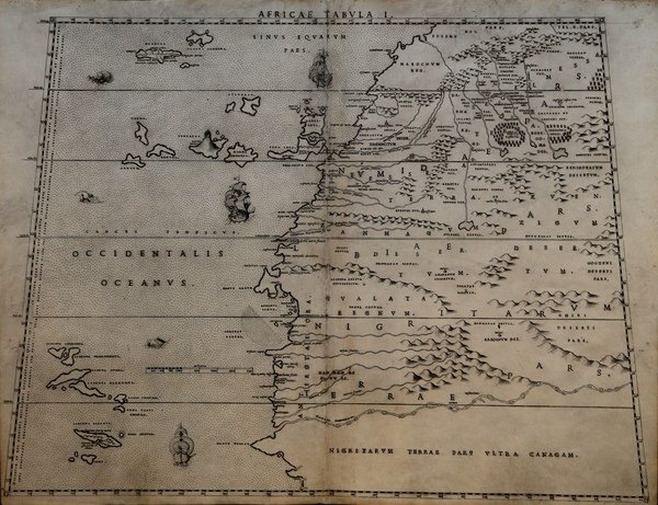
Africae Tabula I
Africae Tabula I | Prints | SANUTO Livio

Africae Tabula I
Africae Tabula I | Prints | SANUTO Livio
Payment methods
- PayPal
- Credit card
- Bank transfer
- Pubblica amministrazione
- Carta del Docente
Details
- Year of publication
- 1588
- Place of printing
- Venezia
- Size
- 520 X 395
- Engravers
- SANUTO Livio
- Keyword
- Cartografia Rara
- Inscription description
- Betz, The Mapping of Africa, p. 145; Norwich, 15; Almagià 1946.
Description
Rarissima carta geografica dell'Africa Occidentale, con gli arcipelaghi delle Canarie e Azzore.La mappa è tratta dal 'Geografia di M. Livio Sanuto : distinta in XII libri : ne quali, oltra l'esplicatione di molti luoghi di Tolomeo, e della Bussola, e dell'Aguglia, si dichiarano le Prouincie, Popoli, Regni. dell'Africa. Con XII tauole di esse Africa in dissegno di rame / aggiuntiui de piu tre Indici da M. Giouan Carlo Saraceni. ; [aiutato a ciò da Giulio suo fratello, che di propia mano tagliò tutti li Rami'.Si tratta del primo atlante dedicato esclusivamnete all'Africa, con le tavole disegnate da Livio Sanuto e finemente tradotte in rame dal fratello Giulio. L'opera venne pubblicata postuma a Venezia nel 1588, da Damiano Zenaro ed a cura di Carlo Saraceni.Incisione in rame, restauri perfettamente eseguit alla piega centrale ed a dei fori di tarlo presenti nella parte superiore ed inferiore, per il resto in ottimo stato di conservazione.Rara ed affascinante mappa dell'Africa. A very rare map of Western Africa, showing the Canary Islands & Azores.The map is taken form 'Geografia di M. Livio Sanuto : distinta in XII libri : ne quali, oltra l'esplicatione di molti luoghi di Tolomeo, e della Bussola, e dell'Aguglia, si dichiarano le Prouincie, Popoli, Regni. dell'Africa. Con XII tauole di esse Africa in dissegno di rame / aggiuntiui de piu tre Indici da M. Giouan Carlo Saraceni. ; [aiutato a ciò da Giulio suo fratello, che di propia mano tagliò tutti li Rami'.First printed atlas of Africa, published postumously by Sanuto's friend Saraceni who added the tables of contents and the preface on the life of the author.The maps were drawn by Sanuto and finely engraved by his brother Jules. The atlas is divided into twelve books, the first containing notes on scientific observation, the declination of the magnetic needle and corrections to the work, the second explains the divisions of Sanuto's prospective description of the world, and the other ten on Africa which was the only section he completed before his death.Livio Sanuto (c.1520-1576), was a Venetian cosmographer, mathematician and maker of terrestrial globes. Sanuto was one of the so-called Lafreri school of engravers, whose output signalled the transition between the maps of Ptolemy and the maps of Mercator and Ortelius. Livio and his brother Giulio, planned a massive and comprehensive atlas to include maps and descriptions of the whole world, which he believed would be more accurate than any previously published. Unfortunately, he died in 1576 having only completed 12 maps of Africa. The 12 maps were eventually published in 1588 by Livio's brother Giulio, under the title "Geografia Di M. Livio Sanuto." . In the compliation of this and the other African maps, Sanuto relied on Gastaldi's 1564 map and Portuguese sea charts for the mapping of the coasts and for information about the interior, used accounts by Duarte Barbosa and João de Barros. After its publication in 1588, this work was copied by other leading map makers for nearly a century afterwards.Seas are decorated with contemporary sailing vessels and monsters.Etching with engraving, some expert repairs at the central folds and at worm holes along the upper and lower edge, otherwise in good condition. Cfr. Betz, The Mapping of Africa, p. 145; Norwich, 15; Almagià 1946.
