Ager Orivetanus
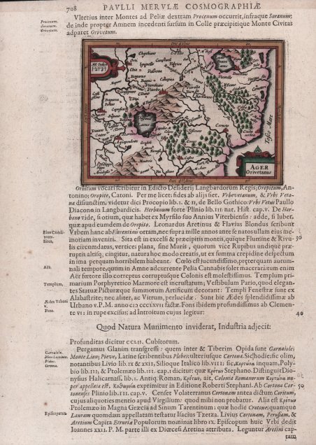
Ager Orivetanus
Payment methods
- PayPal
- Credit card
- Bank transfer
- Pubblica amministrazione
- Carta del Docente
Details
- Year of publication
- 1634
- Place of printing
- Amsterdam
- Size
- 130 X 95
- Engravers
- HONDIUS Jr. Jodocus
Description
Carta geografica in miniatura tratta dal ' Cosmographiae generalis libri tres: item Geographiae particularis libri quatuor, quibus Europa in genere, speciatim Hispania, Gallia, Italia describuntur : cum tabulis geographicis aeneis, multo quam antehac accuratioribus. . Europa & speciatim Hispania ' di Paulus Merula, edizione latina del 1634. L'opera contiene, inserite nel testo, parte delle 219 carte di Jodocus Hondius Jr. che illustrano la nuova versione della Geografia del Bertius, pubblicata nel 1616 e che derivano dal grande atlante di Mercator/Hondius, delle quali molte rappresentano una semplice riduzione. "After the death of Cornelis Claesz in 1609, Jodocus Hondius II became the new publisher of the work, composed by 7 parts in 1, with engraved title-page and 220 full-page engraved maps in text. All the maps were newly engraved and slightly larger in size, because Hondius was not able to acquire the original plates. With the new plates the work was definitely improved and enjoyed a growing demand of the public, which at that time had the choice between the ' Atlas Minor ' by Mercator and Bertius' ' Tabularum Geographicarum. The 219 plates, with the oval world map appearing twice, were produced to illustrate a new version of the geography of Bertius, published in 1616” [cfr. G. King, ' Miniature Antique Maps]. According to G. King, their correct attribution is by Hondius jr., after Mercator and Hondius, taken from Bertius, who was only responsible for revising his text again Acquaforte, in ottime condizioni. Bibliografia G. King, ' Miniature Antique Maps pp. 96-98; ' Alberto Satolli, ' Imago VV, Le rappresentazioni della città di Orvieto dalle origini ad oggi, p. 129, tav. XLI. Miniature map from the Cosmographiae generalis libri tres: item Geographiae particularis libri quatuor, quibus Europa in genere, speciatim Hispania, Gallia, Italia describuntur : cum tabulis geographicis aeneis, multo quam antehac accuratioribus. . Europa & speciatim Hispania by Paulus Merula, Latin edition of 1634. The work contains, inserted in the text, part of the 219 maps by Jodocus Hondius Jr. illustrating the new version of Bertius' Geography, published in 1616 and derived from the great atlas of Mercator/Hondius, of which many represent a simple reduction. According to King, their correct attribution is by Hondius, after Mercator and Hondius, taken from Bertius, who was only responsible for revising his text again. "After the death of Cornelis Claesz in 1609, Jodocus Hondius II became the new publisher of the work, composed by 7 parts in 1, with engraved title-page and 220 full-page engraved maps in text. All the maps were newly engraved and slightly larger in size, because Hondius was not able to acquire the original plates. With the new plates the work was definitely improved and enjoyed a growing demand of the public, which at that time had the choice between the Atlas Minor by Mercator and Bertius' Tabularum Geographicarum. The 219 plates, with the oval world map appearing twice, were produced to illustrate a new version of the geography of Bertius, published in 1616. According to King, their correct attribution is by Hondius, after Mercator and Hondius, taken from Bertius, who was only responsible for revising his text again" [cf. G. King, ' Miniature Antique Maps]. Copperplate, in very good conditions. Bibliografia G. King, ' Miniature Antique Maps pp. 96-98; ' Alberto Satolli, ' Imago VV, Le rappresentazioni della città di Orvieto dalle origini ad oggi, p. 129, tav. XLI. Cfr.