Alpinae seu Foederatae Rhaetiae Subditarumque ei Terrarum nova descriptio
Alpinae seu Foederatae Rhaetiae Subditarumque ei Terrarum nova descriptio | Prints | JANSSONIUS Johannes

Alpinae seu Foederatae Rhaetiae Subditarumque ei Terrarum nova descriptio
Alpinae seu Foederatae Rhaetiae Subditarumque ei Terrarum nova descriptio | Prints | JANSSONIUS Johannes
Payment methods
- PayPal
- Credit card
- Bank transfer
- Pubblica amministrazione
- Carta del Docente
Details
- Year of publication
- 1640
- Place of printing
- Amsterdam
- Size
- 500 X 385
- Engravers
- JANSSONIUS Johannes
Description
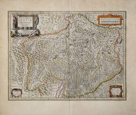
Carta geografica della Valtellina, dei Grigioni e di parte del Comasco e Bergamasco tratta dall’Atlas Novus ' del Janssonius. ' Si tratta di una derivazione o copia della carta inserita nella Appendix di Willelm J. Blaeu del 1630. Secondo Sceffer e Bianchi, la mappa fu originariamente incisa da Evert Symonsz. Hamersveldt (che fu attivo ad Amsterdam tra il 1616-1643) per Hondius, e poi venduta a Willelm Jansz. Blaeu che la inserì nel suo primissimo atlante, l'Atlas Appendix (1630). I confini della Rezia e dei suoi vicini sono delineati a mano e le principali città e paesi sono evidenziati in rosso. Davos e San Moritz, oggi le località più famose della regione, sono mappate, ma non evidenziate in rosso. La topografia alpina della regione è mostrata con pieno effetto, con quasi tutta la lastra coperta di montagne. Il cartiglio del titolo è affiancato da quattro figure: San Lucio di Coira (spesso confuso con Lucio di Britannia), un antico celtico retico, e due divinità fluviali che rappresentano il Reno e l'Inn. Gli altri tre cartigli contengono una dedica a un certo Adrian Pauw, una scala in miglia retiche e italiche, e una chiave per i simboli usati sulla mappa. ' Joannes Janssonius, figlio dell'editore di Arnhem Jan Janssen, sposò Elisabeth Hondius, figlia di Jodocus Hondius, ad Amsterdam nel 1612. ' Dopo il suo matrimonio, si stabilì in questa città come libraio ed editore di materiale cartografico. Nel 1618 si stabilì ad Amsterdam accanto alla libreria di Willem Jansz. Blaeu, entrando in una seria competizione. Le sue attività non riguardavano solo la pubblicazione di atlanti e libri, ma anche di mappe singole e un vasto commercio di libri con filiali a Francoforte, Danzica, Stoccolma, Copenaghen, Berlino, Koningsbergen, Ginevra e Lione. Nel 1631 iniziò a pubblicare atlanti insieme a Henricus Hondius. Nei primi anni 1640 Henricus Hondius lasciò l'attività di pubblicazione di atlanti completamente a Janssonius. La concorrenza con Joan Blaeu, figlio e successore di Willem, nella produzione di atlanti spinse Janssonius ad ampliare il suo ' Atlas Novus ' finalmente in un'opera di sei volumi, in cui furono inseriti un atlante marino e un atlante del Vecchio Mondo. Dopo la morte di Joannes Janssonius, il negozio e la casa editrice furono continuati dagli eredi sotto la direzione di Johannes van Waesbergen (c. 1616-1681), genero di Joannes Janssonius. Le matrici degli atlanti di Janssonius furono in seguito vendute a Schenk e Valck. Incisione in rame, bella coloritura coeva, in perfette condizioni. Map taken from Atlas Novus ' by Janssonius, copy of the map included in the Willelm Jansz. Blaeu Appendix (1630). This regional map of Switzerland and part of Itlay was originally drawn from maps by the Swiss cartographer Fortunato Sprecher à Berneck and Phillip Cluverius. The map was originally engraved by Evert Symonsz. Hamersveldt (born c. 1591/1592) who was active in Amsterdam between 1616-1643 for Hondius, although the plate is one the plates sold to Blaeu which was later published in Blaeus very first atlas, the Atlas Appendix (1630). The borders of Rhaetia and its neighbours are outlined in hand colour, and principal cities and towns are picked out in red. Davos and San Moritz, today the region's most famous locations, are mapped, but not picked out in red. The Alpine topography of the region is shown to full effect, with almost the entire plate covered in mountains. The title cartouche is flanked by four figures: St Lucius of Chur (often conflated with Lucius of Britain), an ancient Rhaetian Celt, and two River Gods representing the Rhine and the Inn. The other three cartouches contain a dedication to one Adrian Pauw, a scale in Rhaetic and Italic miles, and a key to symbols used on the map. ' Joannes Janssonius (Arnhem, 1588-1664), son of the Arnhem publisher Jan Janssen, married Elisabeth Hondius, daughter of Jodocus Hondius, in Amsterdam in 1612. After his marriage, he settled down in this town as a bookseller and publisher of cartographic material. In 1618 he established himself in Amsterdam next door to Blaeu’s book shop. He entered into serious competition with Willem Jansz. Blaeu. His activities not only concerned the publication of atlases and books, but also of single maps and an extensive book trade with branches in Frankfurt, Danzig, Stockholm, Copenhagen, Berlin, Koningsbergen, Geneva, and Lyon. In 1631 he began publishing atlases together with Henricus Hondius. In the early 1640s Henricus Hondius left the atlas publishing business completely to Janssonius. Competition with Joan Blaeu, Willem’s son and successor, in atlas production prompted Janssonius to enlarge his ' Atlas Novus ' finally into a work of six volumes, into which a sea atlas and an atlas of the Old World were inserted. After the death of Joannes Janssonius, the shop and publishing firm were continued by the heirs under the direction of Johannes van Waesbergen (c. 1616-1681), son-in-law of Joannes Janssonius. The copperplates from Janssonius’s atlases were afterwards sold to Schenk and Valck. Contemporary coloring, in good condition. ' Cfr.
