Alpinae seu Foederatae Rhaetiae subditorumque ei Terrarum Nova Descriptio
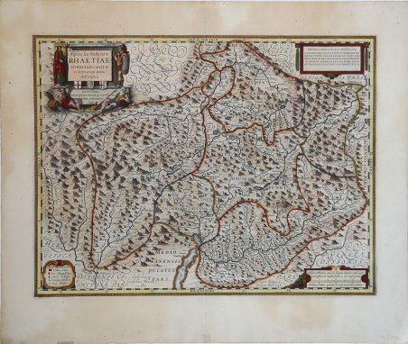
Alpinae seu Foederatae Rhaetiae subditorumque ei Terrarum Nova Descriptio
Payment methods
- PayPal
- Credit card
- Bank transfer
- Pubblica amministrazione
- Carta del Docente
Details
- Year of publication
- 1630
- Place of printing
- Amsterdam
- Size
- 530 X 410
- Engravers
- BLAEU Willem Janszoon
- Inscription description
- Sceffer n. 29; Bianchi n. 64; Perini pag. 68.
Description
Importante e decorativa mappa della Rezia, una regione storica che copre approssimativamente l'odierna Svizzera orientale con parti del Trentino, della Lombardia e del Tirolo, incisa da Evert van Hamersvelt basandosi su una mappa del cartografo svizzero Fortunato Sprecher à Berneck e Phillip Cluverius. Secondo Sceffer e Bianchi, la mappa fu originariamente incisa da Evert Symonsz. Hamersveldt (che fu attivo ad Amsterdam tra il 1616-1643) per Hondius, e poi venduta a Willelm Jansz. Blaeu che la inserì nel suo primissimo atlante, l'Atlas Appendix (1630). I confini della Rezia e dei suoi vicini sono delineati a mano e le principali città e paesi sono evidenziati in rosso. Davos e San Moritz, oggi le località più famose della regione, sono mappate, ma non evidenziate in rosso. La topografia alpina della regione è mostrata con pieno effetto, con quasi tutta la lastra coperta di montagne. Il cartiglio del titolo è affiancato da quattro figure: San Lucio di Coira (spesso confuso con Lucio di Britannia), un antico celtico retico, e due divinità fluviali che rappresentano il Reno e l'Inn. Gli altri tre cartigli contengono una dedica a un certo Adrian Pauw, una scala in miglia retiche e italiche, e una chiave per i simboli usati sulla mappa. Evert Symonsz. van Hamersvelt (1591-1653) fu un incisore olandese con sede ad Amsterdam. Prolifico incisore di mappe, produsse numerose tavole cartografiche per Jodocus Hondius, Jan Jansson e Johan Blaeu, in particolare per le edizioni successive dell'Atlante Mercator-Hondius e per l'Atlas Novus di Jansson. Willem Janszoon Blaeu, avviò nel 1599 la sua attività di costruttore di globi e strumenti astronomici ad Amsterdam. Nel 1630, dopo aver comprato alcune lastre dell’atlante del Mercator da Jodocus Hondius II, fu in grado di pubblicare un volume di 60 mappe con il titolo di ' Atlantis Appendix. Cinque anni dopo, pubblicò i primi due volumi del suo atlante ' Atlas Novus ' o ' Theatrum Orbis Terrarum, ' in sei libri. Dopo la sua morte, Joan (Johannes) continuò l’opera paterna, completando l’intera serie di sei volume dell’Atlas Novus ' intorno al 1655. Fu inoltre autore di un ' Atlas Maior sive Cosmographia Blaviana, in 12 volumi pubblicati nel 1662 -72. A large and decorative map of Rhaetia, a historic region roughly covering modern day eastern Switzerland with parts of Trentino, Lombardy, and the Tyrol, engraved by Evert van Hamersvelt after a map by maps by the Swiss cartographer Fortunato Sprecher à Berneck and Phillip Cluverius, for the Blaeu Atlas Novus. According with Sceffer and Bianchi, the map was originally engraved by Evert Symonsz. Hamersveldt (born c. 1591/1592) who was active in Amsterdam between 1616-1643 for Hondius, although the plate is one the plates sold to Blaeu which was later published in Blaeus very first atlas, the Atlas Appendix (1630). The borders of Rhaetia and its neighbours are outlined in hand colour, and principal cities and towns are picked out in red. Davos and San Moritz, today the region's most famous locations, are mapped, but not picked out in red. The Alpine topography of the region is shown to full effect, with almost the entire plate covered in mountains. The title cartouche is flanked by four figures: St Lucius of Chur (often conflated with Lucius of Britain), an ancient Rhaetian Celt, and two River Gods representing the Rhine and the Inn. The other three cartouches contain a dedication to one Adrian Pauw, a scale in Rhaetic and Italic miles, and a key to symbols used on the map. Evert Symonsz. van Hamersvelt (1591-1653) was a Dutch engraver based in Amsterdam. A prolific map engraver, he produced numerous cartographic plates for Jodocus Hondius, Jan Jansson, and Johan Blaeu, most notably for later editions of the Mercator-Hondius Atlas and for Jansson's Atlas Novus. Willem Janszoon Blaeu, started in 1599 his business as a builder of globes and astronomical instruments in Amsterdam. In 1630, after buying some plates of the Mercator atlas from Jodocus Hondius II, he was able to publish a volume of 60 maps under the title ' Atlantis Appendix. Five years later, he published the first two volumes of his atlas ' Atlas Novus ' or ' Theatrum Orbis Terrarum, in six books. After his death, Joan (Johannes) continued his father's work, completing the entire six-volume ' Atlas Novus ' series around 1655. He was also the author of an ' Atlas Maior sive Cosmographia Blaviana, in 12 volumes published in 1662 -72. Cfr. Sceffer n. 29; Bianchi n. 64; Perini pag. 68.