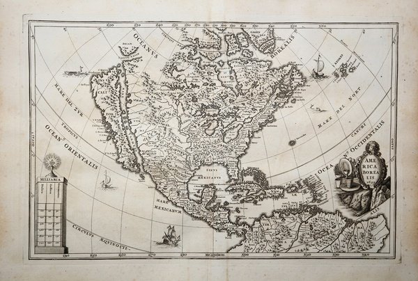
America Borealis 1699
America Borealis 1699
Payment methods
- PayPal
- Credit card
- Bank transfer
- Pubblica amministrazione
- Carta del Docente
Details
- Year of publication
- 1699
- Place of printing
- Monaco
- Size
- 361 X 240
- Engravers
- SCHERER Henrick
- Inscription description
- Tooley (America) p. 131
Description
Decorativa carta geografica dell'America settentrionale che include anche le Antille. La California è rappresentata come un'isola; il fiume Mississipi si origina da due grandi laghi nell'attuale Canada, e sfocia nel "Sinus Mexicanus" collocato troppo a ovest. Decorativa carta geografica pubblicata nell'opera di Heinrich Scherer ' Atlas Novus exhibens orbem terraguem per naturae opera, historiae navae acveterus monumenta, artistique geographicae leges et praecepta ' edita in 8 parti, stampate tra il 1702 e il 1710 a Monaco di Baviera. Heinrich Scherer, professore di matematica a Monaco di Baviera, era un gesuita devoto la cui opera sottolineava la gerarchia cattolica e la diffusione delle missioni gesuite in tutto il mondo. Il suo ' Atlas Novus ' contiene mappe di tutte le altre parti che mostravano la diffusione del cattolicesimo e delle missioni gesuite. “This map of North America dated 1699 appears in the second part of Heinrich Scherer's Atlas Novus entitled Geographia Hierarchica sive Status Ecclesiastici, published in 1703. Much of the cartography is identical although there are more toponyms, particularly of coastal points. The Rocky Mountains are less pronounced. The title is decorated with various plateware signifying the Spanish Empire's output of metal from the Americas. The same plate was used again in the sixth part entitled the Tabellæ Geographicæ, published in the same year, 1703. The atlas was reissued between 1730-37." ' (Burden "The Mapping of North America", p. 475). Incisione su rame, in ottimo stato di conservazione. ' Bibliografia: Burden "The Mapping of North America", pp. 475-476, n. 756; Tooley (America) p. 131. Richly engraved decorative map of North America, showing California as and Island, by Heinrich Scherer (1628-1704). The Great Lakes are prominently depicted and the Mississippi River originates in two large lakes in present-day Canada, and empties into the "Sinus Mexicanus" too far west. The map is decorated with a title cartouche, distance scale, ships and sea monsters. Decorative map by Scherer for his ' Atlas Novus exhibens orbem terraguem per naturae opera, historiae navae acveterus monumenta, artistique geographicae leges et praecepta.published in eight volumes from 1702-1710 in Munich. Scherer, a devout Jesuit, produced this geographical compendium to depict the Catholic hierarchy and the spread of Jesuit missions throughout the world. “This map of North America dated 1699 appears in the second part of Heinrich Scherer's Atlas Novus entitled Geographia Hierarchica sive Status Ecclesiastici, published in 1703. Much of the cartography is identical although there are more toponyms, particularly of coastal points. The Rocky Mountains are less pronounced. The title is decorated with various plateware signifying the Spanish Empire's output of metal from the Americas. The same plate was used again in the sixth part entitled the Tabellæ Geographicæ, published in the same year, 1703. The atlas was reissued between 1730-37." ' (Burden "The Mapping of North America", p. 475). Copper engraving, in very good condition. ' Bibliografia: Burden "The Mapping of North America", pp. 475-476, n. 756; Tooley (America) p. 131. Cfr.