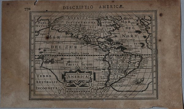
America
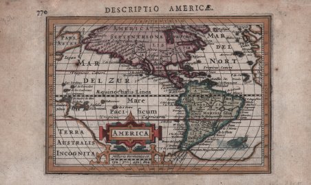
America
Payment methods
- PayPal
- Credit card
- Bank transfer
- Pubblica amministrazione
- Carta del Docente
Details
- Year of publication
- 1616
- Place of printing
- Amsterdam
- Size
- 135 X 97
- Engravers
- HONDIUS Jr. Jodocus
- Languages
- Italian
Description
Mappa in miniatura delle Americhe basata su quella del 1606 di Jodocus Hondius, ma con l'aggiunta della scoperta più recente della Baia di Hudson nel Canada. Questa piccola mappa segna in assoluto la prima apparizione di Baia di Hudson, qui denominata ' Fretum Hudsonium, su una mappa continentale. Il Nord America è mostrato con una grossa sporgenza verso ovest, e il continente è pieno di nomi di luoghi. La costa occidentale presenta una più fitta nomenclatura rispetto alla costa orientale, tra cui ' Anian, Quivira, Tolm, Chuchuco ' e molti altri. ' Virginia, Florida, Chesepiook e St. Augustine ' sono gli unici nomi riportati sulla costa orientale. In Sud America è presente un lago, sull'equatore, vicino alla città di Manoa, e la punta meridionale del continente è quasi unita al grande e mitico continente meridionale della ' Terra Australis Incognita. La Nuova Guinea è unita a questo grande continente, e una parte del Giappone e dell'Asia appaiono nella parte superiore. La mappa è dotata di un elaborato cartiglio decorativo che incorpora la scala di miglia e un mostro marino sulla costa del Sud America. Carta geografica tratta dal ' Tabularum Geographicarum contractarum libri septem ' di Petrus Bertius, edizione latina del 1616. L'opera contiene 219 carte che illustrano questa nuova versione della geografia del Bertius, per la prima volta pubblicata nel 1612 con le carte di Barent Langenes. Le carte derivano dal grande atlante di Mercator/Hondius, delle quali molte rappresentano una semplice riduzione. "After the death of Cornelis Claesz in 1609, Jodocus Hondius II became the new publisher of the work, composed by 7 parts in 1, with engraved title-page and 220 full-page engraved maps in text. All the maps were newly engraved and slightly larger in size, because Hondius was not able to acquire the original plates. With the new plates the work was definitely improved and enjoyed a growing demand of the public, which at that time had the choice between the ' Atlas Minor ' by Mercator and Bertius' ' Tabularum Geographicarum. The 219 plates, with the oval world map appearing twice, were produced to illustrate a new version of the geography of Bertius, published in 1616. According to King, their correct attribution is by Hondius, after Mercator and Hondius, taken from Bertius, who was only responsible for revising his text again" [cfr. G. King, ' Miniature Antique Maps]. “The previous edition of Petrus Bertius' book had appeared in Frankfurt, 1612. It included the Barent Langenes plates of 1598 and the America which was first published by Claesz, 1596. Sometime after this, one would presume before 1616, they passed into the hands of Johannes Cloppenburg. Bertius' text was revised and in 1616 using a new set of plates Jodocus Hondius jr., who was related to Bertius by marriage, issued this enlarged edition. It contained many more maps than the earlier edition, all slightly larger in size. Although Hondius engraved some of the plates himself the map of America is not known to be his work. The author drew on the Hondius sr. map of America from 1606, and for the first time on a continental map incorporated the recent discovery of Hudson Bay. There are more placenames than on the earlier Claesz plate. In 1618 Petrus Bertius was appointed Cosmographer to King Louis XIII and spent the rest of his life in Paris. Sometime after the 1618 editions the plates came into the possession of Joan Blaeu. In 1637 he published an extremely rare atlas entitled Atlas Minor sive Tabulæ Geographicæ, surviving in only two known examples.", (Burden "The Mapping of North America", p. 223). Acquaforte, finemente colorata a mano, in ottimo stato di conservazione. ' Bibliografia: Burden "The Mapping of North America", p. 223, n. 183; King (2nd ed.) pp. 96-99. An uncommon miniature map of the Americas based on the 1606 map of America by Jodocus Hondius senior, but with the addition of the recent discovery of Hudson Bay. This small map marks the first appearance of Hudson Bay on a continental map, named here as Fretum Hudsonium. North America is shown with a large westward bulge, and the continent is filled with place names. The western coast has more names than the eastern coast, including Anian, Quivira, Tolm, Chuchuco and many others. Virginia, Florida, Chesepiook and St. Augustine are the only names on the East Coast. South America features the fictitious lake on the Equator, with the city of Manoa above, and the southern tip of the continent is nearly joined with the large, mythical southern continent of Terra Australis Incognita. New Guinea is shown attached to this large continent, and a portion of Japan and Asia appear above. The map is graced with an elaborate strapwork cartouche that incorporates the distance scale, and a whiskered sea monster swims off the coast of South America. Latin title page on verso. A superior rival to the pocket Ortelius atlas appeared about 1598, under the imprint of Barent Langenes and Cornelis Claesz. Claesz also published the ' Tabularum Geographicarum contractarum libri septem, edition with texy by Petrus Bertius, in 1600. After the death of Cornelis Claesz in 1609, Jodocus Hondius II became the new publisher of the work, composed by 7 parts in 1, with engraved title-page and 220 full-page engraved maps in text. All the maps were newly engraved and slightly larger in size, because Hondius was not able to acquire the original plates. With the new plates the work was definitely improved and enjoyed a growing demand of the public, which at that time had the choice between the ' Atlas Minor ' by Mercator and Bertius' ' Tabularum Geographicarum. The 219 plates, with the oval world map appearing twice, were produced to illustrate a new version of the geography of Bertius, published in 1616. According to King, their correct attribution is by Hondius, after Mercator and Hondius, taken from Bertius, who was only responsible for revising his text again. "After the death of Cornelis Claesz in 1609, Jodocus Hondius II became the new publisher of the work, composed by 7 parts in 1, with engraved title-page and 220 full-page engraved maps in text. All the maps were newly engraved and slightly larger in size, because Hondius was not able to acquire the original plates. With the new plates the work was definitely improved and enjoyed a growing demand of the public, which at that time had the choice between the Atlas Minor by Mercator and Bertius' Tabularum Geographicarum. The 219 plates, with the oval world map appearing twice, were produced to illustrate a new version of the geography of Bertius, published in 1616. According to King, their correct attribution is by Hondius, after Mercator and Hondius, taken from Bertius, who was only responsible for revising his text again" [cf. G. King, ' Miniature Antique Maps]. “The previous edition of Petrus Bertius' book had appeared in Frankfurt, 1612. It included the Barent Langenes plates of 1598 and the America which was first published by Claesz, 1596. Sometime after this, one would presume before 1616, they passed into the hands of Johannes Cloppenburg. Bertius' text was revised and in 1616 using a new set of plates Jodocus Hondius jr., who was related to Bertius by marriage, issued this enlarged edition. It contained many more maps than the earlier edition, all slightly larger in size. Although Hondius engraved some of the plates himself the map of America is not known to be his work. The author drew on the Hondius sr. map of America from 1606, and for the first time on a continental map incorporated the recent discovery of Hudson Bay. There are more placenames than on the earlier Claesz plate. In 1618 Petrus Bertius was appointed Cosmographer to King Louis XIII and spent the rest of his life in Paris. Sometime. Cfr.