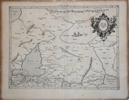
Asiae II Tab.
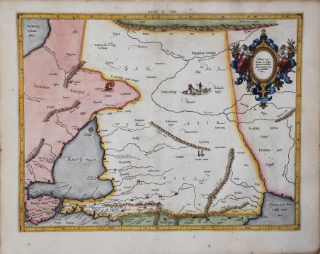
Asiae II Tab.
Payment methods
- PayPal
- Credit card
- Bank transfer
- Pubblica amministrazione
- Carta del Docente
Details
- Year of publication
- 1578
- Place of printing
- Amsterdam
- Size
- 470 X 355
- Engravers
- MERCATOR (Kremer) Gerard
- Languages
- Italian
Description
Mappa tolemaica incentrata centra su una regione storica intrisa di leggenda, di grande importanza nel primo sviluppo del commercio tra l'Asia e l'Europa, la regione della Via della Seta, tra l'Iperborei, le montagne del Caucaso e comprende una parte del Mar Caspio. Quelle regioni dell'Europa orientale che confinano con il Mar Nero sono raffigurate e denominate secondo antichi regni e popoli. Il Mar Nero ha una forma interessante. Costantinopoli non è nominata, ma il Bosforo sì. Si notano numerosi riferimenti agli Sciiti. Vengono citate anche numerose altre antiche civiltà, inclusi i Sarmati, il regno di Mitridati e le Amazzoni, ma erroneamente collocati nella regione dell’Anatolia. La Colchide è mostrata a sud di un'Anatolia molto deforme. ' Mappa tratta dal ' Cl. Ptolemaei Alexandrini, Geographiae Libri Octo, ' pubblicata prima a Colonia da Gottfried von Kempen (1578) e poi ristampata dallo stesso editore nel 1584 (Van der Krogt 1, 502) e poi da Isaac Elsevier per il ' Theatrum Geographiae veteris ' di Petrus Bertius (Leyden 1618). Di tutte le edizioni di Tolomeo, quella di Gerard Kremer (Mercatore), pubblicata nel 1578, e forse tecnicamente la più bella. A questo punto la ' Geografia ' di Tolomeo perdeva però ogni pretesa di “attualità”, laddove lo scopo di Mercatore era quello di produrre un atlante del mondo classico che servisse da complemento al suo atlante moderno (per tale ragione egli aveva tentato di recuperare la forma originale dell’atlante tolemaico, scartandone le moderne accrezioni). L'interpretazione di Mercatore del testo tolemaico, per le 28 carte che illustrano la sua ' Geographia ' è stata, quindi, una delle più veritiere. Egli aveva passato 13 anni a ricercare, disegnare e incidere le carte, rinunciando anche alla pubblicazione delle sue carte “moderne”. Questo esemplare proviene dal ' Theatrum Geographia Veteris ' di Petrus Bertius edita a Leida nel 1618, che combina il Tolomeo di Mercator, le 8 tavole del Moretus per rappresentare la ' Tabula Peutingeriana ' e 14 mappe storiche delle regioni d'Europa derivate dal ' Parergon ' di Ortelius. Acquaforte, finemente colorata a mano, in ottime condizioni. ' This Ptolemaic map focuses on a historical region steeped in legend, one of great importance in the early development of trade between Asia and Europe, the Silk Road region, between the Hyperborei and Caucus Mountains. It includes a portion of the Caspian Sea. Those regions of eastern Europe which border the Black Sea are depicted, and named according to ancient kingdoms and peoples. The Black Sea has an interesting shape. Constantinople is not named, but the Bosphorus is. A number of references to the Scythians are noted. ' A number of other ancient civilizations are also referred to including the Sarmatians, the kingdom of Mithridatis, and the Amazons are named, but in the wrong region or Anatolia. Colchis is shown to the south of a very misshapen Anatolia. Numerous mountain ranges and river systems are shown in detail. ' Map taken from the ' Cl. Ptolemaei Alexandrini, Geographiae Libri Octo, ' first published in Cologne by Gottfried von Kempen (1578) and then reprinted by the same publisher in 1584 (Van der Krogt 1, 502) and then by Isaac Elsevier for the Petrus Bertius’ ' Theatrum Geographiae veteris ' (Leyden 1618). Mercator's interpretation of the 28 Ptolemaic text was possibly one of the truest undertaken up until that time. He had spent 13 years researching, drawing and engraving the maps at much commercial sacrifice to himself, having seen Ortelius's ' Theatrum ' and De Jodes ' Speculum ' published, to become both technical and commercial successes. In later life he devoted himself to his edition of the maps in Ptolemy's ' Geographia, reproduced in his own engraving as nearly as possible in their original form. This example comes from the ' Theatrum Geographia Veteris ' of Petrus Bertius published in Leiden in 1618, which combines Mercator's Ptolemy, the 8 plates of Moretus to represent the ' Tabula Peutingeriana ' and 14 historical maps of the regions of Europe derived from the ' Parergon ' of Ortelius. Copperplate with fine later hand colour, in good condition. Cfr.