Carte Administrative de la France divisé en 110 départements.
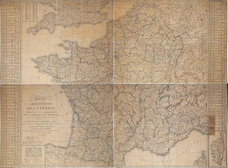
Carte Administrative de la France divisé en 110 départements.
Payment methods
- PayPal
- Credit card
- Bank transfer
- Pubblica amministrazione
- Carta del Docente
Details
- Year of publication
- 1805
- Place of printing
- Parigi
- Size
- 1426 X 1060
- Engravers
- POIRSON Jean-Baptiste
Description
Rarissima grande carta murale della Francia, stampata su quattro fogli di carta vergata (dimensioni 713x530 mm ognuno, per un totale – se unita – di 1426x1060 mm) applicati su tela coeva, più volte ripiegati ad astuccio. Raffigura la Francia nella sua divisione amministrativa sotto il governo di Napoleone Bonaparte. Il distretto amministrativo dipartimentale venne creato con la legge del 22 dicembre 1789. La costituzione del 13 dicembre 1799, confermò la divisione del territorio europeo in dipartimenti e distretti comunali. Una vera e propria "costituzione amministrativa", organizzava il territorio e la sua gestione sotto la figura del prefetto: nominato dal Primo Console (e in seguito dall'Imperatore), era "l'unico responsabile dell'amministrazione" del dipartimento e si rivelava un fattore decisivo nell'applicazione della politica interna. Emetteva decreti, aveva a disposizione la polizia, gestiva le spese, assicurava la riscossione delle tasse e il reclutamento delle truppe. La carta di Poirson raffigura la Francia nel 1805, suddivisa in 110 dipartimenti. Nel 1812, i dipartimenti francesi diventarono 134, di cui 47 "stranieri". La mappa è di grandissima rarità; non ne abbiamo trovato traccia nella collezione della BNF, che ne possiede di successive. Jean-Baptiste Poirson è stato un ingegnere, costruttore di globi, geografo e cartografo francese attivo tra la fine del XVIII e l'inizio del XIX secolo. Poirson, completati gli studi matematici, assume un incarico presso l'editore di mappe Edme Mentelle (1730 - 1815). A partire dal 1790 circa, le mappe iniziano ad apparire sotto l'imprint di Poirson. Avendo ottenuto un certo riconoscimento per aver corretto il lavoro dei geografi precedenti, Porison fece parte di un'équipe che collaborò alla realizzazione di un grande globo terrestre per l'istruzione del Delfino di Francia. Dopo il 1803, fu nuovamente chiamato a produrre un globo aggiornato, questa volta per Napoleone Bonaparte. Tra i suoi lavori più significativi vi sono le mappe associate all'edizione francese dell'Atlas Geographique Et Physique Du Royaume De La Nouvelle-Espagne di Alexander von Humboldt. Lavorò anche con Conrad Malte-Brun (1775 - 1826) e François-Raymond-Joseph de Pons (1751 - 1812). Very rare large wall map of France, printed on four sheets of laid paper (size 713x530 mm each, for a total - when joined - of 1426x1060 mm) laid down to coeval cloth, several times folded into a case. Depicts France in its administrative division under the rule of Napoleon Bonaparte. The departmental administrative district was created by the law of December 22, 1789. The constitution of Dec. 13, 1799, confirmed the division of European territory into departments and municipal districts. A veritable "administrative constitution," it organized the territory and its management under the figure of the Prefect: appointed by the First Consul (and later by the Emperor), he was "solely responsible for the administration" of the department and proved to be a decisive factor in the application of internal policy. He issued decrees, had the police at his disposal, managed expenditures, ensured the collection of taxes and the recruitment of troops. Poirson's map depicts France in 1805, divided into 110 departments. In 1812, French departments became 134, including 47 "foreign" departments. The map is of great rarity; we found no trace of it in the BNF collection, which has later ones. Jean-Baptiste Poirson was a French engineer, globe maker, geographer and cartographer active in the late 18th and early 19th centuries. Poirson, having completed his mathematical studies, took a position with the map publisher Edme Mentelle (1730 - 1815). Beginning around 1790, maps began to appear under Poirson's imprint. Among his most significant works are the maps associated with the French edition of Alexander von Humboldt's Atlas Geographique Et Physique Du Royaume De La Nouvelle-Espagne. He also worked with Conrad Malte-Brun (1775 - 1826) and François-Raymond-Joseph de Pons (1751 - 1812). Cfr.