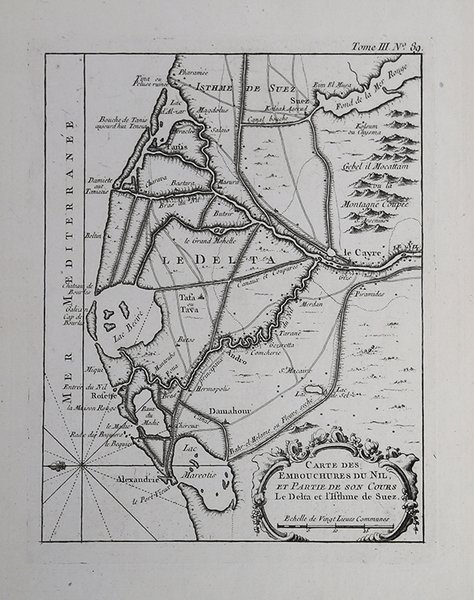
Carte des Embouchures du Nil et partie de Son Cours
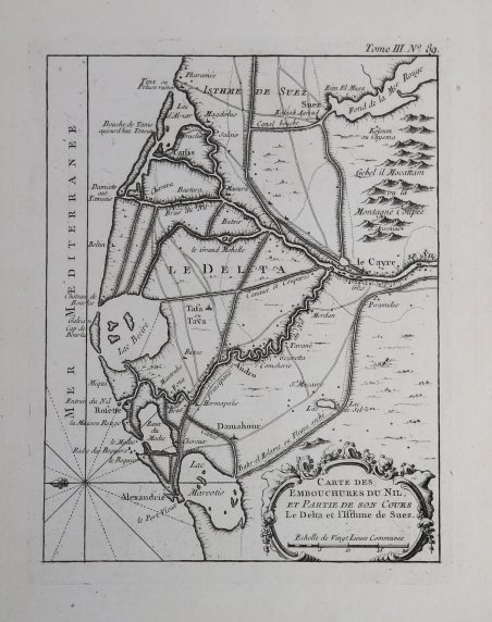
Carte des Embouchures du Nil et partie de Son Cours
Payment methods
- PayPal
- Credit card
- Bank transfer
- Pubblica amministrazione
- Carta del Docente
Details
- Year of publication
- 1764
- Place of printing
- Parigi
- Size
- 185 X 205
- Engravers
- BELLIN Jacques Nicolas
Description
Mappa nautica pubblicata nel "Le Petit Atlas Maritime Recueil De Cartes et Plans Des Quatre Parties Du Monde", edito a Parigi, in 5 tomi, nel 1764."Le Petit Atlas Maritime" è probabilmente la migliore compilazione di piani di città marittime e porti del suo tempo. Secondo Tooley, Bellin pubblicò una versione precedente di questo atlante nel 1763 dal titolo Atlas Petit Francois. Il duca di Choiseul finanziò le spese per la pubblicazione dell'atlante.Incisione su rame, in ottimo stato di conservazione. Nautical map published in "Le Petit Atlas Maritime Recueil De Cartes et Plans Des Quatre Parties Du Monde", issued in Paris, 1764. Decorative title cartouche. Relief shown pictorially and by hachures. Shows settlements."Le Petit Atlas Maritime" is probably the best compilation of plans of maritime towns and harbors of its time. According to Tooley, Bellin issued an earlier version of this atlas in 1763 titled Petit Atlas Francois. The Duc de Choiseul provided financial support for the publication of the atlas. J. Arrivet is listed as engraver on the chart index pages and may also have engraved the charts themselves.Copperplate, outlines colored, in good condition. Cfr.