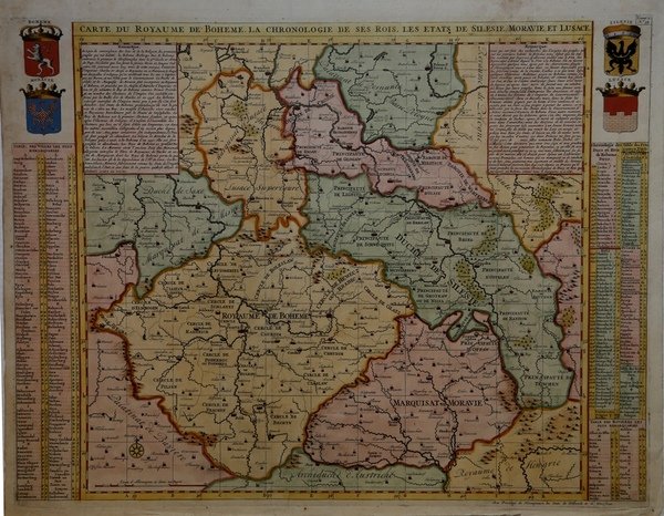
Carte du Royaume de Boheme. La Chronologie de ses Rois. Les Etats de Silesie, Moravie, et Lusace
Carte du Royaume de Boheme. La Chronologie de ses Rois. Les Etats de Silesie, Moravie, et Lusace
Payment methods
- PayPal
- Credit card
- Bank transfer
- Pubblica amministrazione
- Carta del Docente
Details
- Year of publication
- 1708
- Place of printing
- Amsterdam
- Size
- 625 X 480
- Engravers
- CHATELAIN Henri Abraham
Description
Mappa dettagliata della Polonia meridionale, della Boemia e della Moravia, con stemmi per ciascuno dei paesi. Ai lati ci sono liste di città e ducati, e una storia cronologica dei duchi e dei re di Boemia. È una bella carta decorata con quattro stemmi e una rosa dei venti.Carta geografica tratta dall'Atlas Historique, pubblicato ad Amsterdam tra il 1705 e il 1720. L'atlante, in 7 volumi, è innovativo per la sua epoca perché combina le mappe geografiche con incisioni e informazioni di carattere geografico, storico, etnografico e araldico. Henri Abraham Chatelain (1684 - 1743) era un pastore ugonotto di origini parigine. È meglio conosciuto come cartografo olandese e più specificamente per il suo contributo cartografico nell’Atlas Historique ' in sette volumi, pubblicato ad Amsterdam tra il 1705 e il 1720. Innovativo per il suo tempo, l'Atlas Historique ' combinava incisioni e opere d'arte con studi di geografia, storia, etnologia, araldica e cosmografia. Alcuni studiosi suggeriscono che l'Atlas Historique ' non fu compilato esclusivamente da Henri Chatelain, come si crede comunemente, ma piuttosto fu un'impresa familiare che coinvolse Henri, suo padre Zacharie e suo fratello, sempre Zacharie. Incisione in rame, finemente colorata a mano, in ottimo stato di conservazione. Map centered on today Czech Republic, including part of Poland with a key table to the towns on both sides. This is a very attractive and informative map of the region of the present-day Czech Republic, Slovakia and southeastern Poland. At the sides are lists of towns and dukedoms, and a chronological history of the dukes and kings of Bohemia. It is a handsome chart that is decorated with four coats of arms and a compass rose. Etching with fine hand colour, in good condition. Henri Abraham Chatelain (1684 - 1743) was a Huguenot pastor of Parisian origins. He is best known as a Dutch cartographer and more specifically for his cartographic contribution in the seminal seven volume ' Atlas Historique, published in Amsterdam between 1705 and 1720. Innovative for its time, the ' Atlas Historique ' combined fine engraving and artwork with scholarly studies of geography, history, ethnology, heraldry, and cosmography. Some scholarship suggests that the ' Atlas Historique ' was not exclusively compiled by Henri Chatelain, as is commonly believed, but rather was a family enterprise involving Henri, his father Zacharie and his brother, also Zacharie. Cfr.