Charte vom Koenigreich Polen nach seinen ehemahligen (1773) und demahligen Grenzen 1820

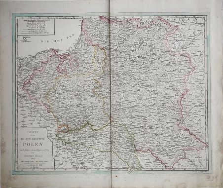
Charte vom Koenigreich Polen nach seinen ehemahligen (1773) und demahligen Grenzen 1820
Payment methods
- PayPal
- Credit card
- Bank transfer
- Pubblica amministrazione
- Carta del Docente
Details
- Year of publication
- 1820
- Place of printing
- Augsburg
- Size
- 618 X 525
- Engravers
- WALCH Johann
- Inscription description
- Cfr. Imago Poloniae (2002), vol. II, pp. 123-124, K55 77/11 (ed. 1793-1807) Michael Ritter, Cartographica Helvetica: Fachzeitschrift für Kartengeschichte, nr. 25-26, 2002
Description
Rarissima carta della Polonia e Lituania, stampata ad Ausburg (Augusta) da Johannes Walch nel 1820. Si tratta del sesto, sconosciuto stato della carta – la carto bibliografia “Imago Polonia” (Varsavia, 2002), che descrive l’incredibile collezione Niewodniczanski contempla solo 5 stati della carta, di cui l’ultimo stampato nel 1807 – per la prima volta edita nel 1793.Incisione in rame, coloritura coeva dei contorni, piccole macchie di umidità negli angoli inferiori, altrimenti in perfetto stato di conservazione.La città imperiale di Augusta era un importante centro di produzione di mappe per l'Europa centrale nel XVIII secolo. Gli incisori più noti erano i residenti Johann Stridbeck e Gabriel Bodenehr, e gli editori d'arte Matthäus Seutter e il suo successore Tobias Conrad Lotter, e Johann Michael Probst, tutti specializzati nella pubblicazione di cartografica e topografica. La graduale recessione economica di Augusta ha lasciato il segno sulla fiorente attività di tipografia ed editoria. Solo Johann Martin Will e soprattutto Johannes Walch hanno impedito la completa scomparsa della produzione di mappe alla fine del XVIII secolo. La continuità della casa editrice Walch fino al momento attuale, tuttavia, non garantisce ampi archivi per la stesura di una cronologia dettagliata dell’editore di mappe tedesco. La casa editrice bruciò durante la seconda guerra mondiale e la maggior parte dei documenti scritti e stampati furono distrutti.Johannes Walch divenne attivo dal 1790 circa come incisore dei propri disegni di carte, sposando la figlia dell’altro editore John Martin Will. Le mappe in formato folio sono l'obiettivo principale del lavoro cartografico di Walch. Alcuni di loro prendono il titolo in modo molto specifico, vale a dire promozione delle vendite, riferimento agli attuali eventi di guerra, come ad esempio la “Neue General-Kriegs- Karte des Rheinstrohms” (3 tavole, 1793), la “Kriegstheater oder Graenzkarte zwischen Frankreich und Italien” (1786) e la “Polen nach seiner ersten, und lezten, oder gaenzlichen Theilung” (1796). Walch, tenendo conto del gusto del tempo, rinunciava completamente agli ornamenti. Le sue carte sono chiare e belle. Sono scritti principalmente in tedesco, in parte anche nell'allora francese alla moda. Le carte del Walch, non essendo parte di un atlante, sono assolutamente rare nel mercato antiquario. A very rare map of Poland and Lithuania by Johannes Walch, first published in 1793, here in his sixt – unknown – state, dated 1820. Imago Poloniae (the carthobibliography of the maps form the Niewodniczanski collection, Warsaw 2002) listed only 5 states of the map, the latest with the date 1807.Copperplate, with fine original outline colouring, light waterstains at the lower corners, otherwise very good condition.The imperial city of Augsburg was a leading center of map production for Central Europe in the 18th Century. Many of the resident copper engravers such as Johann Stridbeck and Gabriel Bodenehr, and the art publishers Matthäus Seutter and his successor Tobias Conrad, and Johann Michael Probst were specialized in the publication of cartographica and topographica.The gradual economic recession of Augsburg left its mark on the once flourishing printing and Publishing business. Only Johann Martin Will and especially Johannes Walch prevented the complete disappearance of map production at the end of the 18th Century. The continuity of the Publishing house Walch up until the present time, however, does not guarantee extensive archives for writing a detailed history of a German map publisher. The Publishing house burned down during World War II and most of the written and printed documents were destroyed.Although Walch and Will also acted as independent publishers in the future, there seems to have been an intimate business combination between the two companies, especially in the area of map production.Johannes Walch became active from about 1790 as engraver of his own map designs. He published his own sheets, but they also appeared partly in Will. In some cases, both names are equal in the map titles. For example, Walch becomes author and publisher, Will called as publisher. So early on, the agreement seems to have existed that Walch would be the publisher's successor to his father-in-law. This is also supported by the common home and business address of the two publishers and in particular the fact that Will does not male successor and his inheritance would have to fall anyway to his daughter and her husband Walch. Maps in folio format are the main focus of Walch's cartographic work. Some of them take in the title very specifically, that is sales-promoting, reference to current events of war, such as Poland after its first, and last, or total division - 1796. Soon, however, his publishing house also found a broad standard program of maps from the regional to the hemispheric map. His engravings are almost entirely editions of foreign originals, and he confessed this only in a few cases in the card title Far more often Walch claimed to have designed a map according to the latest astronomical location rules, most reliable travelogues and most valued resources to have. Walch, taking into account the taste of the time, completely renounced ornamentation. His maps are clear and fine. They are mostly written in German, partly also in the then fashionable French language. The large maps by Walch are not part of an Atlas, so they are quite rare on the antiquarian market. Cfr. Cfr. Imago Poloniae (2002), vol. II, pp. 123-124, K55 77/11 (ed. 1793-1807) Michael Ritter, Cartographica Helvetica: Fachzeitschrift für Kartengeschichte, nr. 25-26, 2002