Cipro
Cipro
Payment methods
- PayPal
- Credit card
- Bank transfer
- Pubblica amministrazione
- Carta del Docente
Details
- Year of publication
- 1688
- Place of printing
- Modena
- Size
- 185 X 140
- Engravers
- PIACENZA Francesco
Description
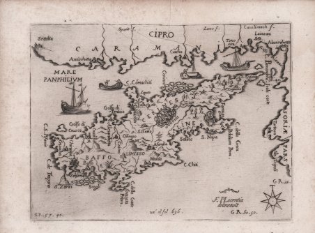
Rara carta dell’isola di Francesco Piacenza, pubblicata come tavola fuori testo nel L’Egeo Redivivo o’sia Chrorographia dell’Arcipelago, e dello stato primiero, & attuale di quell’isole, regni, citta?, populationi, dominii, costumi, sito & imprese, con la breve descrittione particolare si? del suo ambito littorale, che della Grecia, Morea, o’Peloponnese, di Candia, e Cipri, stampato a Modena nel 1688. L’opera, una sorta di “Isolario” come da tradizione veneziana del XVI secolo, include una descrizione molto approfondita e sistematica delle isole dell'Egeo, di Creta, Cipro e del Peloponneso. Le descrizioni di ogni isola sono molto dettagliate riguardo al terreno, alla posizione di città e villaggi, chiese e monasteri. Menzionano la presenza di antiche rovine e forniscono informazioni sulla storia medievale. Le isole meno conosciute sono particolarmente ben trattate. Francesco Piacenza Napolitano, [nato a Napoli nel 1637 e morto a Modena nel 1687], fu dottore in diritto civile e canonico e professore di geografia; fu anche segretario dell'ambasciatore di Sua Maestà Cattolica in Germania per 8 anni, poi a Bologna come segretario del vescovo cardinale Guzman. Divenne membro dell'"Accademia degli Immobili Dissonanti" e frequentò la neonata Università di Modena dove seguì il corso di Scienze Naturali che comprendeva, per la prima volta, lo studio della chimica. Fu incaricato dal duca di Modena Francesco II de Este di recarsi nell'Egeo e di farne una descrizione e una mappa; purtroppo morì prima della pubblicazione de "L'Egeo redivivo" nel 1688. “A small type of map of the island appears in the Italian book: L'Egeo Redivivo, O' Sia Chorographia Dell' Arcipelago ., che della Grecia, Morea, O' Peloponnese, Di Candia, E Cipri, Con le sue Piante in Rame al più viuo incise, Fatiche, E Diligenze Di Francesco Piacenza Napolitano . In Modona 1688. The last 30 pages of the book are devoted to the island of Cyprus (pp. 636-666): "Cipro, Se bene siasi di già coll' Isola antecedente di Rhodi terminata finalmente del tutto la narratiua dell'altre più riguardeuoli, e più da Marinari pratticate dell'Arcipelago con gloria del Christianesimo, à questo Regno i suoi antichi, e legitimi Signori. Between the pages 636 and 637 is inserted a small map of Cyprus signed: F. Placentia delineauit. Francesco Piacenza, or as he signs, Placentia, professor of geography in Modona, author and draughtsman of his own maps, here presents us with a quaint little map of the island, with its few contents edited from various sources, including his own imagination. He marks S. Ilario (St. Hilarion), south-west of Nicosia. He names four of the medieval districts of the island without delineation: Cerines, Baffo, Limisso, Saline. Cipro is written on the opposite coast of Caramania” (cfr. A. Stylianou, The Hystory of the Cartography of Cyrpus, p. 103). “Piacenza's work on the Archipelago was inspired by the Venetian successes in the Morea against the Turks from 1684-1688. He describes each island, and according to his own testimony claims to have visited all the islands he describes. He also claims to have drawn all the maps himself. Certainly the book is full of useful information on the nature of each island and its antiquities, and Piacenza gives the sources for his information, both ancient and contemporary. Following the titles of certain maps, we have added place names, separated by a slash, which occur on the maps themselves so that additional islands can be located. For the most part Piacenza uses a double system of place-names for his maps: he uses the modern name of the island in the title at the upper edge of the plate, but he uses the ancient place names on the map itself. The maps are all in the letterpress except for four: Morea, Candia, Arcipelago and Cipro” (cfr. G. Tolias, Mapping Greece, 1420-1800: A History Maps in the Margarita Samourkas Collection, p. 508). Acquaforte, impressa su carta vergata. Rare map of the island by Francesco Piacenza, published in the L’Egeo Redivivo o’sia Chrorographia dell’Arcipelago, e dello stato primiero, & attuale di quell’isole, regni, citta?, populationi, dominii, costumi, sito & imprese, con la breve descrittione particolare si? del suo ambito littorale, che della Grecia, Morea, o’Peloponnese, di Candia, e Cipri, printed in Modena by Soliani Heirs, 1688. The work, a kind of "Isolario" in the 16th century Venetian tradition, includes a very thorough and systematic description of the islands of the Aegean, Crete, Cyprus and the Peloponnese. The descriptions of each island are very detailed regarding the terrain, location of towns and villages, churches and monasteries. They mention the presence of ancient ruins and provide information about medieval history. Lesser-known islands are particularly well treated. Francesco Piacenza Napolitano, [born in Naples in 1637 and died in Modena in 1687], was a doctor of civil and canon law and professor of geography; he was also secretary to His Catholic Majesty's ambassador to Germany for 8 years, then to Bologna as secretary to Bishop Cardinal Guzman. He became a member of the "Accademia degli Immobili Dissonanti" and attended the newly founded University of Modena where he took the Natural Sciences course that included, for the first time, the study of chemistry. He was commissioned by the Duke of Modena Francesco II de Este to travel to the Aegean and make a description and map of it; unfortunately, he died before the publication of "L'Egeo redivivo" in 1688. “A small type of map of the island appears in the Italian book: L'Egeo Redivivo, O' Sia Chorographia Dell' Arcipelago ., che della Grecia, Morea, O' Peloponnese, Di Candia, E Cipri, Con le sue Piante in Rame al più viuo incise, Fatiche, E Diligenze Di Francesco Piacenza Napolitano . In Modona 1688. The last 30 pages of the book are devoted to the island of Cyprus (pp. 636-666): "Cipro, Se bene siasi di già coll' Isola antecedente di Rhodi terminata finalmente del tutto la narratiua dell'altre più riguardeuoli, e più da Marinari pratticate dell'Arcipelago con gloria del Christianesimo, à questo Regno i suoi antichi, e legitimi Signori. Between the pages 636 and 637 is inserted a small map of Cyprus signed: F. Placentia delineauit. Francesco Piacenza, or as he signs, Placentia, professor of geography in Modona, author and draughtsman of his own maps, here presents us with a quaint little map of the island, with its few contents edited from various sources, including his own imagination. He marks S. Ilario (St. Hilarion), south-west of Nicosia. He names four of the medieval districts of the island without delineation: Cerines, Baffo, Limisso, Saline. Cipro is written on the opposite coast of Caramania” (cfr. A. Stylianou, The Hystory of the Cartography of Cyrpus, p. 103). “Piacenza's work on the Archipelago was inspired by the Venetian successes in the Morea against the Turks from 1684-1688. He describes each island, and according to his own testimony claims to have visited all the islands he describes. He also claims to have drawn all the maps himself. Certainly the book is full of useful information on the nature of each island and its antiquities, and Piacenza gives the sources for his information, both ancient and contemporary. Following the titles of certain maps, we have added place names, separated by a slash, which occur on the maps themselves so that additional islands can be located. For the most part Piacenza uses a double system of place-names for his maps: he uses the modern name of the island in the title at the upper edge of the plate, but he uses the ancient place names on the map itself. The maps are all in the letterpress except for four: Morea, Candia, Arcipelago and Cipro” (cfr. G. Tolias, ' Mapping Greece, 1420-1800: A History Maps in the Margarita Samourkas Collection, p. 508). Etching, printed on contemporary laid paper, with m. Cfr.