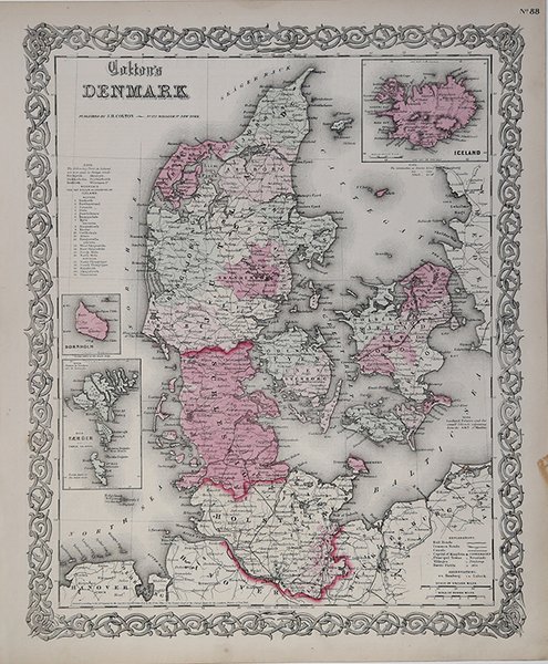
Colton's Denmark
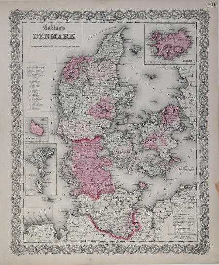
Colton's Denmark
Payment methods
- PayPal
- Credit card
- Bank transfer
- Pubblica amministrazione
- Carta del Docente
Details
- Year of publication
- 1856
- Place of printing
- New York
- Size
- 360 X 432
- Engravers
- COLTON Georg Woolworth
- Inscription description
- Rumsey 0149.078 (1856 edition); Phillips (Atlases) 816
Description
Mappa dettagliata della Danimarca, con province colorate a mano con colori diversi. La mappa mostra città, strade, fiumi, montagne, laghi, isole. Sono presenti due inserti con le mappe dell'Islanda, dell'isola di Bornhom e le isole Fær Øer. Con cornice decorativa. Mappa realizzata da JH Colton, uno dei cartografi americani più prolifici della metà del XIX secolo. Detailed map of Denmark, hand colored by provinces. Shows towns, roads, rivers, mountains, lakes, islands, etc. Inset maps of Iceland, Bornhom and Die Faerger or Faroe Islands. Decorative border. A terrific map, from JH Colton, one of the most prolific American mapmakers of the mid-19th Century. From the scarce 1859 edition, bearing the imprint of Johnson & Browning, one year before these two publishers commenced publication of Johnson's Illustrated Family Atlas of the World. Marvelous vibrant colors. Cfr. Rumsey 0149.078 (1856 edition); Phillips (Atlases) 816