Details
Place of printing
Norimberga
Engravers
HOMANN Eredi Johannes Baptiste
Description
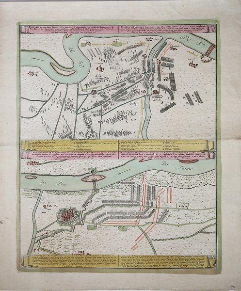
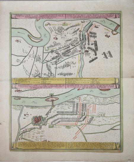
Due carte geografiche in un foglio raffiguranti le battaglie di Guastalla ed il passaggio della Secchia tra le armate di Federico II di Prussia e Carlo Alessandro d'Austria. Johann Baptist Homann è stato un geografo e cartografo tedesco; nel 1702 fondò la sua casa editrice. Homann acquisì fama come uno dei principali cartografi tedeschi, e nel 1715 fu nominato geografo imperiale dall'imperatore Carlo VI. Nello stesso anno fu anche nominato membro dell'Accademia Prussiana delle Scienze a Berlino. Nel 1716 Homann pubblicò il suo capolavoro Grosser Atlas ueber die ganze Welt. Numerose mappe furono redatte in collaborazione con l'incisore Christoph Weigel. Homann morì a Norimberga nel 1724. Gli successe suo figlio Johann Christoph (1703-1730). L'azienda continuò dopo la sua morte come azienda degli eredi Homann, gestita da Johann Michael Franz e Johann Georg Ebersberger. Dopo successivi cambiamenti nella gestione, l'azienda si sciolse nel 1852. ' Incisione in rame, coloritura coeva, in ottimo stato di conservazione. 2 engraved plans ( partly in bird's eye perspective) partly nice handcoloured with battle-arryas and individual positions and legend engraved below. With descriptive text printed in German and Italian. In Nice condition. Detailed carthographic impression of the second battle in the seventh year war between the army of Friedrich II of Prussia and Prinzen Karl Alexander von Lothringen from Austria. Near Prague in Czech Republic. Published separately not a map from an atlas. 1. Battle between the armies of Friedrich II and the French in Secchia near the Po river. 2. Battle of Guastalla 1734 between the Franco-Sardinan troops and Austro-Prussian forces. Johann Baptist Homann was a German geographer and cartographer; in 1702 he founded his own publishing house. Homann acquired renown as a leading German cartographer, and in 1715 was appointed Imperial Geographer by Emperor Charles VI. In the same year he was also named a member of the Prussian Academy of Sciences in Berlin. In 1716 Homann published his masterpiece Grosser Atlas ueber die ganze Welt; numerous maps were drawn up in cooperation with the engraver Christoph Weigel the Elder. Homann died in Nuremberg in 1724 and was succeeded by his son Johann Christoph (1703-1730). The company carried on upon his death as Homann heirs company, managed by Johann Michael Franz and Johann Georg Ebersberger. After subsequent changes in management the company folded in 1852. Etching with fine original colour, good condition. Cfr.

 Find out how to use
 Find out how to use