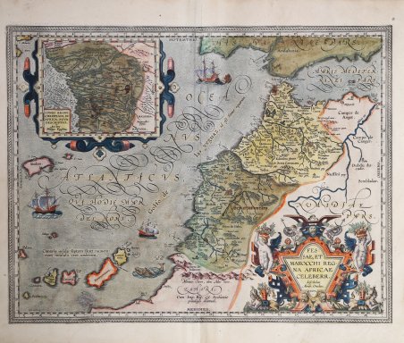
Titolo: FES:|SAE, ET | MAROCCHI REG:|NA AFRICAE | CELEBERR. | "describebat | Abrah. Ortelius. | 1595". Nel mezzo: "Cum Imp. Reg. & Brabantiæ | priuilegio decennali". Cartiglio con una carta dell’Africa Occidentale (130x158 mm): CONGI REGNI | CHRISTIANI, IN | AFRICA, NOVA | DESCRIPTIO. | "Auctore | Philippo Pigafetta". Splendido esemplare della carta dei regni di Fez e del Marocco. La carta mostra la regione che va da Taroudant, nel Marocco centrale, attraverso Marrakech, fino al Marocco settentrionale e alla Spagna meridionale. Le Canarie sono visibili nella parte inferiore sinistra della mappa. La carta comprende un favoloso grande cartiglio, una serie di velieri e vari mostri marini. In alto a sinistra compare un meraviglioso cartiglio dell'Africa occidentale, intitolato Congi Regni Christiani, in Africa, Nova Descriptio. Questa carta è stata compilata da Ortelio a partire da diverse fonti, tra cui l'atlante dell'Africa di Sanuto del 1588 e la carta murale dell'Africa di Gastaldi del 1564. L'inserto dell'Africa occidentale segue la mappa del Congo di Pigafetta del 1591. La carta del Congo di Pigafetta è significativa per il suo rivoluzionario rifiuto della rappresentazione tolemaica dell'Africa interna, allora ancora seguita dai cartografi (tra cui Ortelius). Esemplare nel primo stato di due secondo Van den Broecke, con la data 1595. Dalla rara edizione italiana del Theatrum Orbis Terrarum stampata ad Anversa da Jean Baptiste Vrients nel 1608 e poi nel 1612. Il Theatrum Orbis Terrarum ' è considerato il primo vero “atlante” moderno. L’opera fu pubblicata in 7 lingue e 36 edizioni, per il quale – nel 1570 - Ortelius ottenne il ' privilegio, ovvero una sorta di diritto d'autore che impediva ad altri cartografi di pubblicare i propri lavori. Il ' Theatrum ' rappresentava il lavoro più avanzato del lavoro della descrizione cartografica. L’Ortelius vi raccolse il sapere geografico e cartografico del suo tempo, proponendo in 147 spettacolari tavole incise l’immagine più fedele del mondo allora conosciuto e, in alcune straordinarie “carte storiche”, regioni e itinerari tratti dalla letteratura, dalla mitologia, dalla tradizione. Ortelius fu anche il primo a citare le fonti, menzionando i nomi dei cartografi nel “catalogus auctorum”. Dal 1598 al 1612 le edizioni postume del ' Theatrum ' furono realizzate dal suo collaboratore Johannes Baptiste Vrients. Acquaforte, finemente colorata in epoca, minime ossidazioni, per il resto in buono stato di conservazione. Bibliografia W. Bodenstein "Ortelius' Maps of Africa", p. 185-208 in: Van den Broecke, van der Krogt and Meurer (eds.) "Abraham Ortelius and the First Atlas", HES Publishers, 1998. Title: FES:|SAE, ET | MAROCCHI REG:|NA AFRICAE | CELEBERR. | "describebat | Abrah. Ortelius. | 1595". Middle bottom: "Cum Imp. Reg. & Brabantiæ | priuilegio decennali". Inset map of 130x158 mm: CONGI REGNI | CHRISTIANI, IN | AFRICA, NOVA | DESCRIPTIO. | "Auctore | Philippo Pigafetta". Wonderful example of the map of the kingdoms of Fez and Morocco. The map shows the region from Taroudant in central Morocco through Marrakech to northern Morocco and southern Spain. The Canary Islands are visible in the lower left part of the map. The map includes a fabulous large cartouche, a series of sailing ships and various sea monsters. A wonderful cartouche of West Africa appears in the upper left, entitled Congi Regni Christiani, in Africa, Nova Descriptio. This map was compiled by Ortelius from several sources, including Sanuto's 1588 atlas of Africa and Gastaldi's 1564 wall map of Africa. The West Africa insert follows Pigafetta's 1591 map of Congo. Pigafetta's map of Congo is significant for its revolutionary rejection of the Ptolemaic representation of interior Africa, then still followed by cartographers (including Ortelius). Example of the first state of two according to Van den Broecke, showing the date 1595. From the rare Italian edition of ' Theatrum Orbis Terrarum ' printed in Antwerp by Jean Baptiste Vrients in 1608 and then in 1612. The ' Theatrum Orbis Terrarum is considered the first true modern "Atlas". The work was published in 7 languages and 36 editions, for which - in 1570 - Ortelius obtained the privilege, a kind of copyright that prevented other cartographers from publishing his works. The ' Theatrum ' represented the most advanced work of cartographic description. Ortelius collected in it the geographical and cartographic knowledge of his time, proposing in 147 spectacular engraved plates the most faithful image of the world then known and, in some extraordinary "historical maps", regions and routes taken from literature, mythology, tradition. Ortelius was also the first to cite sources, mentioning the names of cartographers in the "catalogus auctorum". From 1598 to 1612 the posthumous editions of the ' Theatrum ' were made by his collaborator Johannes Baptiste Vrients. Copper engraving, contemporary coloring, in good condition. Bibliografia W. Bodenstein "Ortelius' Maps of Africa", p. 185-208 in: Van den Broecke, van der Krogt and Meurer (eds.) "Abraham Ortelius and the First Atlas", HES Publishers, 1998. Cfr.

 Find out how to use
 Find out how to use