Details
Place of printing
Amsterdam
Engravers
Valck & Schenk Tipografia
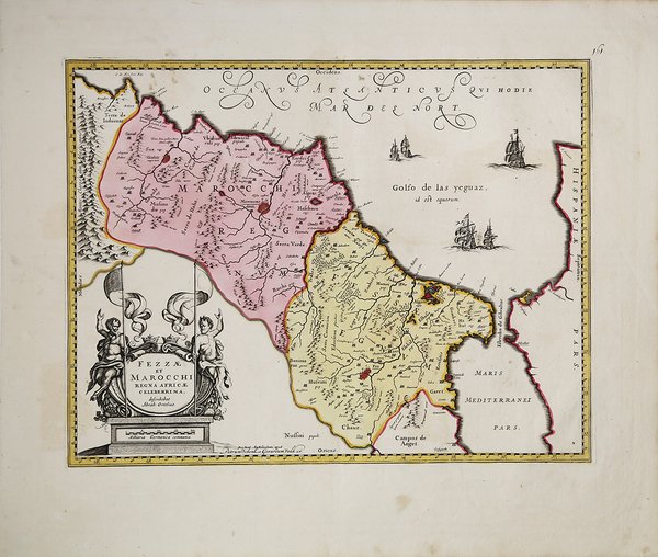
Description
Mappa del Marocco, che mostra le grandi città fortificate di Marrakesh, Taroudant e Fez, città, montagne, fiumi, laghi, ecc. Anche Tanger, Cueta e Rio Rabata appaiono.Sono presenti un grande cartiglio decorativo con il titolo e dei velieri. Ortelius è accreditato nel titolo come fonte della mappa.Carta geografica tratta dal “Atlantis sylloge compendiosa or Nova totius Geographia” edito ad Amsterdam all’inizio del XVIII secolo (circa 1705). La lastra utilizzata per questa incisione, come la maggior parte di quelle usate nella produzione di questi due editori, è quella di J. Janssonius, debitamente modificata e ritoccata. Si tratta dello stesso rame stampato da Joannes Janssonius nel 1645, con la sola aggiunta del reticolo geografico e la modifica dell'imprint editoriale, che diventa "apud G. Valk et P. Schenk". Il reticolo grafico ha una scansione di mezzo grado. La datazione, così come la provenienza di tale carta, ossia l'inserimento di tale carta in un atlante, è molto problematica. Petrus Schenk I (1660-1718 ca) fu incisore ed editore tedesco, trasferitosi giovanissimo ad Amsterdam dove divenne allievo di Gerad Valk (1656-1726) e del quale sposò la sorella Agatha nel 1687. L'associazione tra i due risale già ai primi anni 80 del Seicento; intorno al 1690 si trovarono ad acquistare gran parte dei rami di Janssonius che furono da loro editi con piccoli ritocchi e modifiche. È molto probabile che il rame sia stato stampato ancora e commercializzato anche nel corso del Settecento a opera degli eredi Leonard Valk (1675-ante 1755) e Petrus Schenk II (1698-1775)Incisione in rame, coloritura coeva, in ottimo stato di conservazione. A striking map of Morocco, showing large fortified towns of Marrakesh, Taroudant and Fez, towns, mountains, rivers, lakes, etc. Tanger, Cueta and Rio Rabata also appear.Large decorative cartouche and sailing ships. Ortelius is credited in the title as the map source.Map taken from "Atlantis sylloge compendious or Nova totius Geographia" published in Amsterdam in the early eighteenth century (around 1705). This is the same copperplate printed by Joannes Janssonius in 1645, with only the addition of the geographic grid and the change of the editorial imprint, which becomes "apud G. Valk et P. Schenk." The graphic reticle has a half-degree scan. The dating, as well as the provenance of such a chart, i.e. the inclusion of such a chart in an atlas, is very problematic. Petrus Schenk I (c. 1660-1718) was a German engraver and publisher who moved to Amsterdam at a very young age where he became a pupil of Gerad Valk (1656-1726) and whose sister Agatha he married in 1687. The association between the two dates back as early as the early 1680s; around 1690 they happened to acquire most of Janssonius's copperplates, which were edited by them with minor retouches and modifications.Copper engraving, coloring coeval, in excellent condition. Cfr.


 Find out how to use
 Find out how to use