Globi Coelestis in Tabulas planas redacti pars VI
Globi Coelestis in Tabulas planas redacti pars VI
Payment methods
- PayPal
- Credit card
- Bank transfer
- Pubblica amministrazione
- Carta del Docente
Details
- Year of publication
- 1742
- Place of printing
- Norimberga
- Size
- 585 X 500
- Engravers
- DOPPELMAIER Gabriel
- Keyword
- Carte Celesti
- Languages
- Italian
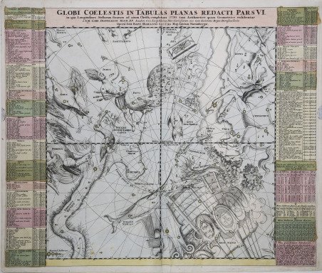
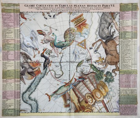
Description
Carta celeste raffigurante le costellazioni zodiacali, rappresentate nella classica forma di animali mitologici. Si tratta della carta numero 25 dell’Atlas Coelestis (1742) di Johann Gabriel Doppelmaier che il professore di matematica all’Aegidien Gymnasium di Norimberga, rifacendosi in parte al lavoro di Pardies, redasse intorno al 1720 per conto dell’officina tipografica fondata nella stessa città nel 1702 dal cartografo Johann Baptist Homann. La mappa, la sesta di sei che unitamente riproducono l’intera volta stellata, è quadrata di 43,4 centimetri di lato, rappresenta le costellazioni contenute nell’emisfero meridionale fino a 45° di declinazione sud. La proiezione gnomonica è concava, cioè geocentrica, e le stelle, suddivise in classi graduate di sei magnitudini, sono posizionate calcolando la precessione degli equinozi per l’anno 1730, ' vengono identificate da lettere dell’alfabeto latino, la successione ricomincia per ogni costellazione e corrisponde all’elenco ' posizionato a destra e sinistra della carta dove, per ogni stella, troviamo le coordinate in latitudine e longitudine, la magnitudine e la descrizione della posizione anatomica nel personaggio mitologico . In tre riquadri vengono riportate le correzioni da apportare alle longitudini per tener conto del fenomeno della precessione degli equinozi tra il 1700 ed il 1760. Un ultimo riquadro dà le indicazioni per utilizzare le tre tabelle precedenti. I reticoli di riferimento permettono di calcolare la posizione delle stelle in riferimento alla loro ascensione retta e declinazione (tacche di un grado) ma anche alla loro latitudine e longitudine (linee ogni 10 gradi). Sono evidenziate le linee dei coluri degli equinozi e dei solstizi, il circolo polare meridionale, il polo antartico e quello eclittico australe. ' Oltre alle costellazioni tolemaiche di pertinenza della zona vengono descritte o disegnate le seguenti costellazioni non tolemaiche: Crux, le cui stelle sono elencate insieme a quelle del Centauro, Robur Caroli e Phoenix, Grus, Indus, Pavo, Toucan, Dorado, Hydrus, Piscis Volans, Chamaleon, Apis Indica, Triangulum Australe , Apis, le dodici costellazioni osservate negli ultimi anni del sedicesimo secolo dai navigatori P. D. Keyser e F. de Houtman durante un loro viaggio nell'Oceano Indiano e che le avevano ideate per ripartirvi le 135 stelle osservate e catalogate con la precisione di circa due gradi. Nella tavola sono disegnate anche la Piccola e la Grande Nube di Magellano e con precisione la Via Lattea Meridionale. Incisione in rame, coloritura coeva con alcuni ritocchi posteriori, in ottimo stato di conservazione. Celestial chart depicting the zodiacal constellations, represented in the classic form of mythological animals. This is map number 25 of the Atlas Coelestis (1742) by Johann Gabriel Doppelmaier that the professor of mathematics at the Aegidien Gymnasium in Nuremberg, referring in part to the work of Pardies, wrote around 1720 on behalf of the printing house founded in the same city in 1702 by cartographer Johann Baptist Homann. The map, the sixth of six that together reproduce the entire starry vault, is square with 43.4 cm side, represents the constellations contained in the southern hemisphere up to 45 ° south declination. The gnomonic projection is concave, i.e. geocentric, and the stars, divided into graded classes of six magnitudes, are positioned by calculating the precession of the equinoxes for the year 1730, are identified by letters of the Latin alphabet, the succession begins again for each constellation and corresponds to the list positioned to the right and left of the chart where, for each star, we find the coordinates in latitude and longitude, the magnitude and the description of the anatomical position in the mythological character. In three boxes are reported the corrections to be made to the longitudes to take into account the phenomenon of precession of the equinoxes between 1700 and 1760. A last box gives indications to use the three previous tables. The reference grids allow the calculation of the position of the stars with reference to their right ascension and declination (notches of one degree) but also to their latitude and longitude (lines every 10 degrees). The lines of the equinoxes and solstices, the southern polar circle, the Antarctic pole and the southern ecliptic pole are highlighted. ' In addition to the Ptolemaic constellations pertaining to the area are described or drawn the following non-Ptolemaic constellations: Crux, whose stars are listed along with those of the Centaur, Robur Caroli and Phoenix, Grus, Indus, Pavo, Toucan, Dorado, Hydrus, Piscis Volans, Chamaleon, Apis Indica, Triangulum Australe , Apis, the twelve constellations observed in the last years of the sixteenth century by navigators P. D. Keyser and F. de Houtman during one of their voyages in the Indian Ocean and who had designed them to distribute the 135 stars observed and cataloged with the precision of about two degrees. Copper engraving, contemporary coloring with fine later addition, in excellent condition. Cfr. Whitfield, Mapping of the Heavens, pp. 93, 96-97. Tooley, R.V., Maps and Map-Makers. p. 27; Kanas, Nick. 2009. Star Maps: History, Artistry, and Cartography. Springer/Praxis.