Het Noordelijkste deel van Africa, behelzende Barbarie, Egypt alsmede de gehel Middellandshche Zee, volgens de nieuwste uitg
Prints
TIRION Isaak
1762
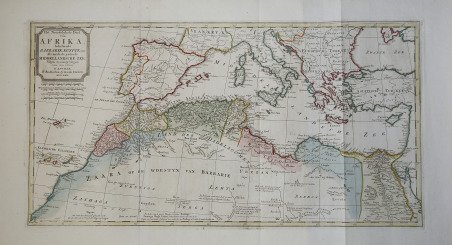

Het Noordelijkste deel van Africa, behelzende Barbarie, Egypt alsmede de gehel Middellandshche Zee, volgens de nieuwste uitg
Prints
TIRION Isaak
1762
250.00 €
(Roma,
Italy)
Payment methods
- PayPal
- Credit card
- Bank transfer
- Pubblica amministrazione
- Carta del Docente
Details
- Year of publication
- 1762
- Place of printing
- Amsterdam
- Size
- 330 X 630
- Engravers
- TIRION Isaak
Description
Decorativa carta geografica del Nord Africa, basata sul modello del D'Anville.La carta rappresenta tutto il Mar Mediterraneo.Incisione in rame, finemente colorata a mano, in ottimo stato di conservazione. Decorative map of North Africa, based on the D’Anville model. The map represents the entire Mediterranean Sea. Copper engraving, fine original colour, excellent condition. Cfr.