Hindoustan ou Inde en deça du Gange
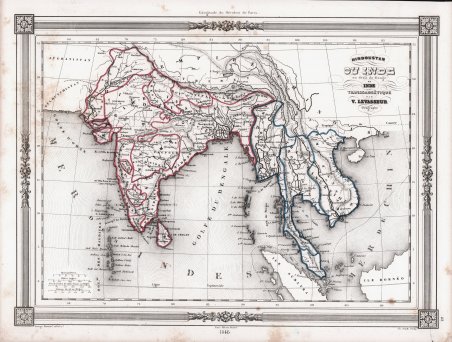
Hindoustan ou Inde en deça du Gange
Payment methods
- PayPal
- Credit card
- Bank transfer
- Pubblica amministrazione
- Carta del Docente
Details
- Year of publication
- 1846
- Place of printing
- Parigi
- Size
- 335 X 255
- Engravers
- LEVASSEUR Victor
Description
Mappa preparata da Victor Levasseur, per essere pubblicata nell'edizione del 1848 dell'Atlas Illustre ' pubblicato dalla casa editrice Maison Basset. La Maison Basset (1819 - 1865) è stata un'azienda editoriale francese attiva nella metà e nella fine del XIX secolo, fondata da André Basset (o Bassett), che iniziò a pubblicare mappe, stampe e libri intorno al 1768. La Maison Basset, o ' Chez Basset, è il marchio con cui gli eredi di Paul-André Basset (1785-1819) pubblicarono le opere di importanti cartografi e incisori francesi come Barbie du Bocage, A. Vuillemin, J. B. Charle, V. Levasseur, Tu. Duvotenay, H. Dufor, F. E. George e altri. La loro biblioteca di pubblicazioni è varia e vasta, ma fortemente incentrata su testi medici e scientifici, tra cui alcuni importanti atlanti. Victor Levasseur, nato l'8 dicembre 1800 a Caen e morto il 4 febbraio 1870 a Parigi, è stato un ingegnere geografo e geometra impiegato presso il Dipartimento di Ingegneria del Catasto e della Città di Parigi a metà del XIX secolo. Figlio del generale di brigata Victor Levasseur, è noto soprattutto per il suo grande ' Atlas (National) Illustré des 86 (89 après 1859) Départements et des Possessions de La France ' che mostra i dipartimenti francesi e le colonie francesi in America, Africa e Asia. I suoi lavori cartografici e le sue statistiche sono oggi apprezzati più per le caratteristiche decorazioni che circondano le mappe che per i dettagli delle mappe stesse. Incisione in rame con contorno originale a colori, alcune ossidazioni, per il resto buono stato di conservazione. Map prepared by Victor Levasseur for publication in Maison Basset's 1848 edition of ' Atlas Illustre Destine a l'enseignement de la Geographie elementaire. Maison Basset (1819 - 1865) was a French publishing concern active through the mid to late 19th century. The firm can trace their roots to André Basset (or Bassett) (fl. 1768 - 1784), who starting publishing maps, prints, and books around 1768. Maison Basset, also ' Chez Basset, is the imprint under which the heirs of Paul-André Basset (1785 - 1819) published the works of such prominent French cartographers and engravers as Barbie du Bocage, A. Vuillemin, J. B. Charle, V. Levasseur, Tu. Duvotenay, H. Dufor, F. E. George, and others. Their library of publications is diverse and vast, but heavily focused on medical and scientific texts, including several important atlases. Victor Levasseur was an engineer-geographer and surveyor employed by the Engineering Department of the Cadastre and City of Paris in the mid-19th century. The son of Brigadier General Victor Levasseur, he is best known for his large ' Atlas (National) Illustré des 86 (89 après 1859) Départements et des Possessions de La France ' showing French departments and French colonies in America, Africa and Asia. His cartographic works and statistics are appreciated today more for the characteristic decorations surrounding the maps than for the details of the maps themselves. Copper engraving with original outline colour, some foxing, otherwise good condition. Cfr.