Iava Insula
Iava Insula
Payment methods
- PayPal
- Credit card
- Bank transfer
- Pubblica amministrazione
- Carta del Docente
Details
- Year of publication
- 1540
- Place of printing
- Basilea
- Size
- 80 X 120
- Engravers
- Münster Sebastian
Description
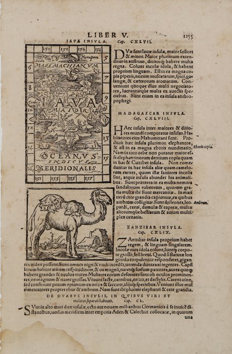
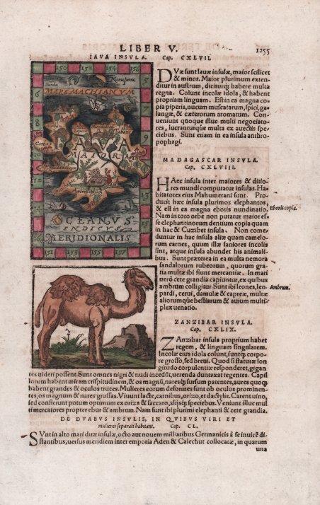
Mappa di Giava, con una breve descrizione dell'isola, sotto la descrizione di Madagascar, Zanzibar e "Duabus Insulis". Sul verso una descrizione dell'"Imperium Cathay". Carta tratta dalla ' Geographia universalis, vetus et nova, complectens. Claudii Ptolemaei Alexandrini Ennarationis libros VIII, pubblicata per la prima volta nel 1540 a Basilea da Heinrich Petri, figliastro di Münster e suo fidatissimo stampatore. Il volume è illustrato da 27 carte costruite seguendo le indicazioni di Tolomeo, a cui si affiancano 21 carte “moderne”, delineate in base alle recenti scoperte geografiche. La ' Geographia ' di Münster ebbe un notevole successo, e Petri la ristampò l'anno seguente (1541) e quello successivo ancora. Aumentate di sei le carte moderne, tra le quali la ' Carta Marina ' di Olao Magnus descrittiva della Scandinavia, l'editore la ristampò ancora nel 1545, nel 1551 e infine nel 1552, sempre con 54 carte geografiche, ma con la sostituzione della ' Pomerania ' al posto del ' Lago di Costanza. Alla scomparsa di Münster l’opera non venne più ristampata; alcune delle carte furono invece utilizzate da Heinrich Petri per le edizioni postume della ' Cosmographiae Universalis. Le matrici lignee, debitamente emendate, furono poi utilizzate per il ' Rerum Geographicarum ' dello Strabo, edizione stampata a ' Basileae: Ex Officina Henricpetriana, 1571 Mense Augusto. Silografia, finemente colorata a mano, in ottimo stato di conservazione. ' A wood block printed map of Java (125x76mm.) with a short description of the island, underneath description of Madagascar , Zanzibar and "Duabus Insulis" . On verso a description of "Imperium Cathay" (China). From a Latin text edition of his ' Geographia, that great compendium of Renaissance knowledge. The ' Geographia universalis, vetus et nova, complectens. Claudii Ptolemaei Alexandrini Ennarationis libros VIII, ' was published for the first time in 1540 in Basel by Heinrich Petri, stepson of Münster and his trusted printer. The book is illustrated by 27 maps built following the indications of Ptolemy, which are flanked by 21 "modern" maps, outlined on the basis of recent geographical discoveries. The ' Geographia ' of Münster was a great success, and Petri reprinted it the following year (1541) and then in 1542. Having increased the number of modern maps by six, including the ' Carta Marina ' of Olao Magnus describing Scandinavia, the publisher reprinted it again in 1545, in 1551 and finally in 1552, still with 54 maps, but with the substitution of ' Pomerania ' in place of ' Lake Constance. At the death of Münster the work was not reprinted; some of the maps were instead used by Heinrich Petri for the posthumous editions of the ' Cosmographiae Universalis. The woodblock of the maps, duly amended, were used for the ' Rerum Geographicarum ' of Strabo, edition printed in ' Basileae: Ex Officina Henricpetriana, 1571 Mense Augusto. Woodcut, fine later hand colour, in excellent condition. Cfr.