Imperium Japonicum Per Regiones Digestum Sex et Sexaginta Atque Ex Impsorum Japonensium Mappis…

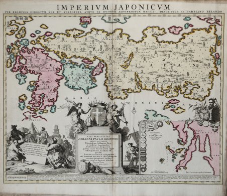
Imperium Japonicum Per Regiones Digestum Sex et Sexaginta Atque Ex Impsorum Japonensium Mappis…
Payment methods
- PayPal
- Credit card
- Bank transfer
- Pubblica amministrazione
- Carta del Docente
Details
- Year of publication
- 1715
- Place of printing
- Amsterdam
- Size
- 605 X 500
- Engravers
- Reland Adriaan
- Inscription description
- Hubbard, The Mapping of Japan, p. 282, n. 68.5
Description
Un bell'esemplare dell'edizione di Reiner & Joshua Ottens della mappa del Giappone di Adrian Reland, la prima mappa che utilizza caratteri sino-giapponesi su una carta stampata europea e rappresenta un radicale allontanamento dalle precedenti mappe europee del Giappone. Pubblicata per la prima volta nel 1715 (Utrecht) con l'imprint di Wilhelm Broedelet, la mappa fu ristampata dalla famiglia Ottens. Secondo Jason Hubbard questo è il quarto stato, pubblicato intorno al 1740, che mostra l'indirizzo "Amstelodami Apud R. & I. Ottens" in basso a destra. Invece di seguire le precedenti mappe europee e le fonti geografiche, Reland ha utilizzato le mappe giapponesi, in particolare una mappa della biblioteca di Benjamin Dutry, un ex direttore della VOC (Compagnia delle Indie Orientali) olandese. Per alcuni aspetti, ciò ha rappresentato un enorme balzo in avanti nella rappresentazione geografica del Giappone, soprattutto nella denominazione delle 66 province. La mappa apparve per la prima volta nel 1715 nel volume 3 del "Recuiel de voiages "di Jean Frederic Benard. Fu poi rieditata da Reland e Wilehm Broedelet in un formato più grande nel 1715, per essere inserita in atlanti in folio. I rami furono acquistate da Joachim Ottens nel 1720 circa e successivamente rieditate con il suo nome e più tardi con i nomi dei suoi figli, Joshua e Reiner. “Japanese mapmaking began to have a significant influence on European maps after the publication of Adriaan Reland's map in 1715. Walter (1994) writes that, with the exception of the delineation of Ky?sh?, the map represented ".a step backward in the depiction of Honsh? in Western cartography with respect to the level reached in Moreira/Blancus and even with respect to Teixeira/Ortelius." The portrayal of the Japanese islands is similar to the map of Ishikawa Tomonobu (Ryusen), 1691. The only portion of the map drawn from Western sources is the inset of the area around Nagasaki. The decorative scenes on either side of the dedication to Jean-Paul Bignon in the lower centre are taken from illustrations in Arnoldus Montanus's Gedenkwaerdige Gesantschappen Der Oost-Indische Maatschappy in 't Vereenigde Nederland.1669, and republished a number of times in several languages. The map is divided into sixty-six 'Kingdoms' or provinces and each is identified in Chinese characters, or Kanji, as well as in Romanji or Western writing; but the place-names have been phonetically rendered in Dutch, which may have posed a challenge to readers of French. The text on the tablet in the lower left reads: ' Queen of the eastern sea, you who are the first to see the sun-horses called forth from the red coloured sea and who - spread over twice thirty coasts - so enjoys showing yourself off to people of various countries. Here we Batavians settled. Should I then believe that anything can be left untouched by our citizens? In the lower centre of the map the dedication to Jean-Paul Bignon reads: This map of the Japanese Empire is dedicated by Adriaan Reland to the very illustrious Jean-Paul Bignon, abbot of St. Quentin, counsellor to the all-powerful King of France for religious affairs, chairman of the Royal universities to whose care the sciences and inscriptions (on monuments and medals) have been entrusted, and outstanding promoter of Chinese and Japanese literature as well as the Fine Arts and all Sciences. The dedication is decorated, above, with two angels holding a crown above a blue shield with a white cross and a bishop's miter both resting on a pedestal; below, samples of ceramics. Jean-Paul Bignon (Paris 1662 - L'Île Belle 1743) was a French ecclesiastic, statesman, writer, preacher (prédicateur) and librarian. He studied at the Collège d'Harcourt and at the Saint-Magloire seminary. He was ordained in 1691, and in 1693 made abbot of Saint-Quentin-en-L'Isle, preacher and librarian to Louis XIV and member of the Académie française. In 1701 he became a member and secretary of l'Académie ro. Fine example of the Reiner & Joshua Ottens issuesof the Adrian Reland's map of Japan, the first map to use Sino-Japanese characters on a European printed map and represents a radical departure from prior European maps of Japan. First published in 1715 (Utrecht) with the imprint of Wilhelm Broedelet, the map was kater reprinted by the Ottens family. According with Jason Hubbard this is the fourth state, published around 1740 and showing the imprint "Amstelodami Apud R. & I. Ottens" at lower right. Instead of following prior European maps and geographical sources, Reland utilized Japanese maps, most notably a map from the library or Benjamin Dutry, a former director of the Dutch VOC (East India Company). In some respects, this represented a tremendous leap forward in the geographical depiction of Japan, such as in the treatment of Kyushu and in naming the 66 provinces. The map first appeared in 1715 in volume 3 of Jean Frederic Benard's Recuiel de voiages. It was thereafter reissued by Reland and Wilehm Broedelet in a larger format in 1715, for inclusion in folio atlases. The plates from the enlarged edition were purchased by Joachim Ottens in about 1720 and thereafter reissued under his name and later the names of his sons, Josua and Reiner. Large inset of the area around Nagasaki and an ornate dedication cartouche, with about 20 coats of arms. “Japanese mapmaking began to have a significant influence on European maps after the publication of Adriaan Reland's map in 1715. Walter (1994) writes that, with the exception of the delineation of Ky?sh?, the map represented ".a step backward in the depiction of Honsh? in Western cartography with respect to the level reached in Moreira/Blancus and even with respect to Teixeira/Ortelius." The portrayal of the Japanese islands is similar to the map of Ishikawa Tomonobu (Ryusen), 1691. The only portion of the map drawn from Western sources is the inset of the area around Nagasaki. The decorative scenes on either side of the dedication to Jean-Paul Bignon in the lower centre are taken from illustrations in Arnoldus Montanus's Gedenkwaerdige Gesantschappen Der Oost-Indische Maatschappy in 't Vereenigde Nederland.1669, and republished a number of times in several languages. The map is divided into sixty-six 'Kingdoms' or provinces and each is identified in Chinese characters, or Kanji, as well as in Romanji or Western writing; but the place-names have been phonetically rendered in Dutch, which may have posed a challenge to readers of French. The text on the tablet in the lower left reads: ' Queen of the eastern sea, you who are the first to see the sun-horses called forth from the red coloured sea and who - spread over twice thirty coasts - so enjoys showing yourself off to people of various countries. Here we Batavians settled. Should I then believe that anything can be left untouched by our citizens? In the lower centre of the map the dedication to Jean-Paul Bignon reads: This map of the Japanese Empire is dedicated by Adriaan Reland to the very illustrious Jean-Paul Bignon, abbot of St. Quentin, counsellor to the all-powerful King of France for religious affairs, chairman of the Royal universities to whose care the sciences and inscriptions (on monuments and medals) have been entrusted, and outstanding promoter of Chinese and Japanese literature as well as the Fine Arts and all Sciences. The dedication is decorated, above, with two angels holding a crown above a blue shield with a white cross and a bishop's miter both resting on a pedestal; below, samples of ceramics. Jean-Paul Bignon (Paris 1662 - L'Île Belle 1743) was a French ecclesiastic, statesman, writer, preacher (prédicateur) and librarian. He studied at the Collège d'Harcourt and at the Saint-Magloire seminary. He was ordained in 1691, and in 1693 made abbot of Saint-Quentin-en-L'Isle, preacher and librarian to Louis XIV and member of the Académie française. In 1701 he became a member and secretary of l'A. Cfr.