Italien
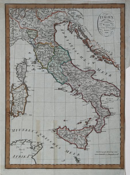
Italien
Payment methods
- PayPal
- Credit card
- Bank transfer
- Pubblica amministrazione
- Carta del Docente
Details
- Year of publication
- 1808
- Place of printing
- Weimar
- Size
- 310 X 435
- Engravers
- WEIMAR Istituito Geografico
Description
Carta dell’Italia di August Ferdinand Götze, pubblicata a Weimar dal Geographische Institut nel 1808. La carta fu pubblicata in seguito al progetto editoriale di Friedrich Justin Bertuch (1747-1822), Adrian Christian Gaspari (1752-1830) e Franz Xaver von Zach 1754-1832) di creare un aggiornato atlante geografico di alta qualità scientifica e artistica e a prezzi misurati. Il tramite editoriale fu il Landes Industrie Comptoir, fondato da Bertuch nel 1791. Molte mappe furono incise a partire dal 1796, ma i vorticosi cambiamenti politici di quegli anni determinarono l'aggiornamento continuo delle mappe e portarono al fallimento di questa prima iniziativa editoriale. Per tali motivi le carte pubblicate in quegli anni dal Landes Industrie Comptoir, fino al 1803, sono messe in vendita come carte sciolte (al più inserite in pubblicazioni periodiche) e non facenti parte di alcun atlante. In tale prima stesura delle carte, dopo il titolo vi è – generalmente - il seguente testo “Nach den be- währtesten Hülfsmitteln neu entworfen und gezeichnet von F. Goetze. Weimar Im Verlage des Industrie Comptoir 1801”. Nel 1803 Bertuch e August Ferdinand Götze (ca 1775- dopo 1816), autori di numerose mappe, presero in mano l'edizione dell'Handatlas ' ma, a partire dal 1804, compare come dato editoriale il nome del ' Geographische Institut ' fondato sempre a Weimar come divisione autonoma della casa editrice madre, con il compito di incidere e pubblicare carte geografiche e atlanti scolastici e storici. Con tale imprint editoriale, e con la data modificata al 1804, lo stesso rame è pubblicato nella prima edizione - dell' ' Allgemeiner Handatlas, ' di Adrian Christian Gaspari (1752-1830). Durante la pubblicazione dell'Allgemeiner Handatlas nel Geographische Institut si pensò di realizzare un'edizione in formato ridotto per incontrare un più vasto pubblico. Nel titolo è chiaramente dichiarato il nuovo e differente mercato cui quest'opera era indirizzata, cioè "per le Scuole pubbliche e per lettori di giornali". Le carte furono quasi tutte tratte dall'Allgemeiner Handatlas ma ridotte in dimensione, spesso dimezzate, e semplificate. La carta dell’Italia è una copia ridotta di quella realizzata da August Ferdinand Götze nel 1801. Viene pubblicata in Neueste Kunde der Schweiz und Italiens. Nach ihrem jessi gen Zustande aus den besten Quellen bargestellt von Theophil Frie- drich Ehrmann. Mit Karten und Kupfern. Weimar im Verlage des F. S. privil. Landes = Industrie Comptoir. Acquaforte con coloritura coeva dei contorni, in buono stato di conservazione. Map of Italy by August Ferdinand Götze, published in Weimar by the Geographische Institut in 1808. The map was published as a result of the publishing project of Friedrich Justin Bertuch (1747-1822), Adrian Christian Gaspari (1752-1830) and Franz Xaver von Zach 1754-1832) to create an up-to-date geographic atlas of high scientific and artistic quality and at measured prices. The publishing medium was the Landes ' Industrie Comptoir, founded by Bertuch in 1791. Many maps were engraved beginning in 1796, but the whirlwind political changes of those years resulted in the continuous updating of maps and led to the failure of this early publishing venture. For these reasons the maps published in those years by the Landes ' Industrie Comptoir, until 1803, are offered for sale as loose maps (at most included in periodical publications) and not part of any atlas. In that first draft of the maps, after the title there is-usually-the following text "Nach den be- währtesten Hülfsmitteln neu entworfen und gezeichnet von F. Goetze. Weimar Im Verlage des Industrie Comptoir 1801". From 1804 the map is included in editions of the ' Allgemeiner Handatlas, the first complete edition of which appears in the years 1804-1806 but with the editorial imprint of the ' Geographische Institut. During the publication of the Allgemeiner Handatlas in the Geographische Institut, it was planned to produce a reduced-format edition to meet a wider audience. The title clearly states the new and different market to which this work was addressed, namely, "for Public Schools and Newspaper Readers". The maps were almost all taken from the Allgemeiner Handatlas but reduced in size, often halved, and simplified. The map of Italy is a reduced copy of one made by August Ferdinand Götze in 1801. It is published in Neueste Kunde der Schweiz und Italiens. Nach ihrem jessi gen Zustande aus den besten Quellen bargestellt von Theophil Frie- drich Ehrmann. Mit Karten und Kupfern. Weimar im Verlage des F. S. privil. Landes = Industrie Comptoir. Etching, contemporary coloring, in very good condition. ' Cfr.