Details
Place of printing
Francoforte
Engravers
BELLIN Jacques Nicolas
Inscription description
L. Walter, "Japan a cartographic vision", p. 224, 111.
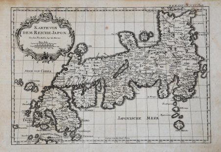
Description
Carta geografica del Giappone nella rara edizione tedesca a cura di Gebauer, stampata circa nel 1763. “The first state of the map is a direct copy of J.-N. Bellin's map included the previous year in the 10th volume of Prévost's Histoire Générale Des Voyages. The map appears in the 'Elfter Band' (vol. 11) of this Leipzig series. In order to use the same plate for their French-language version, publishers Arkstee & Merkus had it reworked by translating the title cartouche back into French and adding French titles above the German ones to major features such as the seas of Japan and Korea; or by substituting French for German (Isle Awasi versus Insel Awas?); or by adding French below the German (Partie des_Isles de Liqueio). In the second state, the subtitle has been altered to: Pour Servir a l'Histoire Universelle d'une Societé de Gens de Lettres from the original French Pour Servir a l'Histoire Générale des Voyages. The map appears in the 20th volume next to page 411. The third state was included in an, as yet, unidentified publication." (Hubbard "Japoniae Insulae – The Mapping of Japan", p. 360). Incisione in rame, in ottimo stato di conservazione. Rara. ' Bibliografia: Hubbard "Japoniae Insulae – The Mapping of Japan", pp. 360-362, n. 105.1; Walter, "Japan a cartographic vision", p. 224, n. 111. Geographic map of Japan in the rare German edition edited by Geubauer, printed approximately in 1763. “The first state of the map is a direct copy of J.-N. Bellin's map included the previous year in the 10th volume of Prévost's Histoire Générale Des Voyages. The map appears in the 'Elfter Band' (vol. 11) of this Leipzig series. In order to use the same plate for their French-language version, publishers Arkstee & Merkus had it reworked by translating the title cartouche back into French and adding French titles above the German ones to major features such as the seas of Japan and Korea; or by substituting French for German (Isle Awasi versus Insel Awas?); or by adding French below the German (Partie des_Isles de Liqueio). In the second state, the subtitle has been altered to: Pour Servir a l'Histoire Universelle d'une Societé de Gens de Lettres from the original French Pour Servir a l'Histoire Générale des Voyages. The map appears in the 20th volume next to page 411. The third state was included in an, as yet, unidentified publication." (Hubbard "Japoniae Insulae – The Mapping of Japan", p. 360). Copper engraving, in excellent condition. Very rare. ' Bibliografia: Hubbard "Japoniae Insulae – The Mapping of Japan", pp. 360-362, n. 105.1; Walter, "Japan a cartographic vision", p. 224, n. 111. Cfr.


 Find out how to use
 Find out how to use