L'Asie Avec le Nouvelles découvertes
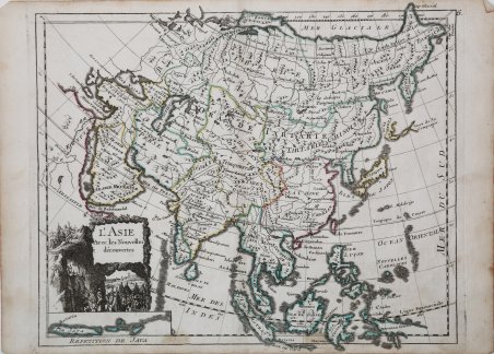
L'Asie Avec le Nouvelles découvertes
Payment methods
- PayPal
- Credit card
- Bank transfer
- Pubblica amministrazione
- Carta del Docente
Details
- Year of publication
- 1756
- Place of printing
- Parigi
- Size
- 285 X 230
- Engravers
- ROUGE Georg Louis le
Description
Interessante mappa dell'Asia del XVIII secolo con una inserto dedicato all'isola di Giava in basso a sinistra.Mostra gran parte delle Indie Orientali, il nord del Giappone (indefinito con il nome Terre de Yeso) e la mitica Terre de la Compagnie, adiacente.In basso a sinistra, il cartiglio decorativo con titolo e una scena di marcia militare.Carta geografica tratta dal raro "Introduction a la Geographie" di G. Louis Le Rouge, pubblicato a Parigi tra il 1747 ed il 1756, a "Paris, chez l'Auteur, Prault le fils, la Veuve Robinot, 1756".L'opera, che l'autore definisce come "Atlas Nouveau Portatif à l'Uage des Militaires et du Voyageur', contiene 86 carte geografiche.Incisione in rame, coloritura coeva dei contorni, in ottimo stato di conservazione. 18th century attractive map of Asia with an inset map of Java. Shows most of the East Indies. North of Japan is undefined Terre de Yeso and the fictitious Terre de la Compagnie next to it. Cartouche with military procession.Map taken from the "Introduction a la Geographie" published from 1747 and 1756, printed in "Paris, chez l'Auteur, Prault le fils, la Veuve Robinot, 1756".The work, which the author defines as "Atlas Nouveau Portatif à l'Usage des Militaires et du Voyageur", contains 86 maps.Copperplate with original outline colour, very good conditions. Cfr.