L'Isle de l'Elbe
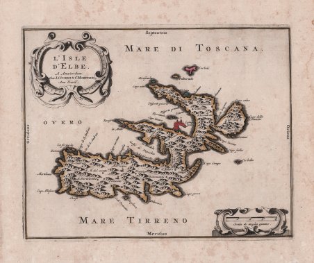
L'Isle de l'Elbe
Payment methods
- PayPal
- Credit card
- Bank transfer
- Pubblica amministrazione
- Carta del Docente
Details
- Year of publication
- 1740
- Place of printing
- Amsterdam
- Size
- 250 X 200
- Engravers
- COVENS & Cornelis MORTIER Johannes
Description
Rara ristampa della carta di W.J. Blaeu dell’isola d’Elba, eseguita sul modello di Giovanni Antonio Magini, a sua volta basata sull’affresco di Egnatio Danti nella Galleria Vaticana. Esemplare tratto da Atlas nouveau, contenant toutes les parties su Monde, ou sont exactement remarquees les empires, monarchies, royaumes, etats, republiques, &c. Par Guillaume de l'Isle. Premier Geographe de sa Majeste. A Amsterdam, Chez Jean Covens & Corneille Mortier, sur le Vygendamm, ' circa 1740. Parte delle lastre della tipografia di Blaeu vennero acquistate dalla tipografia di Covens & Mortier alla fine del XVII secolo. La tavola viene stampata, con modifiche nelle iscrizioni nel mare, con un nuovo privilegio e con l'imprint dalla ditta Covens & Mortier che sono aggiunti nel cartiglio. Johannes Covens (1697-1774) è stato un editore geografico olandese con sede ad Amsterdam. È noto soprattutto per la sua collaborazione con l'editore Cornelis Mortier (1699-1783). Pierre Mortier il Vecchio (1661-1711) aveva ottenuto nel 1690 il privilegio di distribuire le opere dei geografi francesi nei Paesi Bassi. Dopo che la vedova continuò l'attività per alcuni anni, Cornelis ne assunse la direzione nel 1719. Nel 1721, Mortier si mise in società con Covens, che aveva da poco sposato la sorella di Cornelis. I due pubblicarono sotto il nome comune di Covens & Mortier. Nel 1774, alla morte del padre, Johannes Covens II (1722-1794) rilevò la quota paterna. Nel 1778, la società cambiò nome in J. Covens & Zoon, o J. Covens & figlio. L'azienda era specializzata nella pubblicazione di geografi francesi, tra cui De L’Isle, Jaillot e Sanson. Pubblicarono anche atlanti, ad esempio una riedizione del 1725 dell'Atlas Major ' di Frederik de Wit e un atlante, con aggiunte, delle opere di Guillaume Delisle. Al suo apice, l'azienda possedeva la più grande collezione di stampe geografiche mai riunita ad Amsterdam. Acquaforte con bella coloritura antica, leggero foxing, per il resto in ottimo stato di conservazione. Rare reprint of W.J. Blaeu's map of the island of Elba, executed on Giovanni Antonio Magini's model, itself based on Egnatio Danti's fresco in the Vatican Gallery. Map taken from the ' Atlas nouveau, contenant toutes les parties su Monde, ou sont exactement remarquees les empires, monarchies, royaumes, etats, republiques, &c. Par Guillaume de l'Isle. Premier Geographe de sa Majeste. A Amsterdam, Chez Jean Covens & Corneille Mortier, sur le Vygendamm, ' circa 1740. Johannes Covens (1697-1774) was a Dutch geographic publisher based in Amsterdam. He is best known for his collaboration with fellow publisher Cornelis Mortier (1699-1783). Pierre Mortier the Elder (1661-1711) had obtained a privilege in 1690 to distribute the works of French geographers in the Netherlands. After his widow continued the business for several years, Cornelis took over in 1719. In 1721, Mortier forged a partnership with Covens, who had recently married Cornelis’ sister. They published under the joint name of Covens & Mortier. ' In 1774, upon the death of his father, Johannes Covens II (1722-1794) took over his father’s share. In 1778, the company changed its name to J. Covens & Zoon, or J. Covens & son. Covens II’s son, Cornelis (1764-1825), later inherited the business and brought Petrus Mortier IV back into the fold. Petrus was the great-grandson of Petrus Mortier I. From 1794, the business was called Mortier, Covens & Zoon, or Mortier, Covens, & Son. The business specialized in publishing French geographers including Deslisle, Jaillot, and Sanson. They also published atlases, for example a 1725 reissue of Frederik de Wit’s ' Atlas Major ' and an atlas, with additions, from the works of Guillaume Delisle. There were also Covens & Mortier pocket atlases and town atlases. The company profited from acquiring plates from other geographers as well. For example, the purchased Pieter van der Aa’s plates in 1730. Finally, they also compiled a few maps in house. At their height, they had the largest collection of geographic prints ever assembled in Amsterdam. Copperplate with original colouring, light foxing, otherwise very good condition. Cfr.