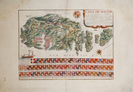
L'Isle de Malthe Et celle de Goze et de Comino
L'Isle de Malthe Et celle de Goze et de Comino | Prints | DE FER Nicolas
L'Isle de Malthe Et celle de Goze et de Comino
L'Isle de Malthe Et celle de Goze et de Comino | Prints | DE FER Nicolas
Payment methods
- PayPal
- Credit card
- Bank transfer
- Pubblica amministrazione
- Carta del Docente
Details
- Year of publication
- 1722
- Place of printing
- Parigi
- Size
- 518 X 380
- Engravers
- DE FER Nicolas
Description
Rara rappresentazione delle isole di Malta, Goze e Comino con sotto 3 modanature con gli stemmi dei Gran Maestri. Incisione in rame di Estienne Vouillemont, stampata per la prima volta a Parigi nel 1662. Qui nel suo secondo stato, emendato, pubblicato da Nicolas De Fer. Estienne Vouillemont (nato nel 1650 circa - 1670 circa) fu un incisore di mappe, piante e giochi da tavolo attivo in Francia nella metà del XVII secolo. Ricoprì la carica ufficiale di "Graveur Ordinaire du Roy" e fu titolare di un privilegio da parte del Re di Francia. La sua carta di Malta si trova inserita in alcuni atlanti di Pierre Duval. La carta comprende un'enorme quantità di dettagli topografici, insieme a circa 75 stemmi dei Gran Maestri dell'Ordine dei Cavalieri di San Giovanni, risalenti alla fondazione dell'Ordine nel 1050. Il Sovrano Militare Ordine Ospedaliero di San Giovanni di Gerusalemme di Rodi e di Malta è un ordine religioso laico cattolico romano, tradizionalmente di natura militare, cavalleresca e nobiliare. È la continuazione moderna dell'originario ordine medievale di San Giovanni di Gerusalemme, noto come Cavalieri Ospitalieri, un gruppo fondato a Gerusalemme intorno al 1050 come ospedale amalfitano per fornire assistenza ai pellegrini poveri e malati in Terra Santa. Dopo la conquista di Gerusalemme nel 1099 durante la Prima Crociata, divenne un ordine militare con un proprio statuto. Dopo la perdita dei territori cristiani di Terra Santa a favore dei musulmani, l'Ordine operò da Rodi (1310-1523) e successivamente da Malta (1530-1798), di cui era sovrano. Carta tratta da: Atlas ou Recueil de cartes geographiques Dressées Sur les Nouvelles Observations de Mrs de l’Academie Royale des Sciences Par N. de Fer, Geographe de sa Majesté Catolique et de Monseigneur le Dauphin. A Paris, chez l’Auteur dans l’Isle du Palais sur le Quay de l’Orloge a la Sphere Royale. Avec privilege du Roy 1709. Nicolas de Fer (1646-1720) è stato uno dei più grandi cartografi, incisori ed editori del XVII secolo. Il padre, Antoine de Fer, era un modesto mercante di stampe che lavorava sull’Ile del la Cité a Parigi; collaborò con Nicolas I Berey, poi con Melchior Tavernier e, quindi, con Jacques Lagnet. Nel 1652 Antoine adotta l’insegna commerciale della “Sphére royale”, già appartenuta a Tavernier; nel 1657 stampa ' Cartes de géographie, una piccola raccolta tascabile di Pierre Duval. Nel 1667 si firmava “merchand de cartes Gèographique”; proseguì l’attività fino al 1686, quando lasciò la tipografia nelle mani del figlio Nicolas, che aveva fatto da apprendista all’incisore parigino Louis Spirinx e aveva già realizzato la sua prima mappa del Canal du Midi, all’età di soli 23 anni. Nel 1689 realizzò una mappa della Franche-Comté per onorare il Grand Dauphine - Luigi di Francia (1661-1711), primogenito ed erede del re Luigi XIV di Francia, impegnato al comando di una campagna di conquistare di nuovi territori sul Reno. In seguito, venne nominato geografo ufficiale del Delfinato e la sua produzione fu strettamente legata agli interessi della corona francese: ad esempio, ' Forces De L’Europe Ou Introduction A La Fortification, pubblicato nel 1695, che mostrava le nuove fortificazioni progettate dall’innovativo ingegnere francese Sébastien de Vauban. Fu il geografo ufficiale anche di Filippo V e Luigi XIV (entrambi i rami francese e spagnolo della Casa di Borbone) e infine, nel 1720, del Papa. De Fer pubblicò l’Atlas curieux où le Monde représenté dans les cartes générales et particulièrs du Ciel et de ' la Terre ' tra il 1700 e il 1705, aggiungendo ogni volta delle nuove tavole geografiche. La sua opera più maestosa rimane l’Atlas Royal, dans l’Isle du Palais sur le Quay de l'Orloge a la Sphere royale ' (1693). Alla sua morte, l’attività fu ereditata da suo genero Guillaume Danet, che si unì poi con Jacques-François Benard. Acquaforte, impressa su carta vergata coeva e finemente colorata a ma. Fine example of the Vouillemont/De Fer's decorative map of Malta. Rare depiction of the islands of Malta, Goze and Comino with 3 moldings below with the coats of arms of the Grand Masters. Copper engraving by Estienne Vouillemont, first printed in Paris in 1662. Here in its second state, amended, published by Nicolas De Fer. Estienne Vouillemont (born c. 1650 - c. 1670) was an engraver of maps, plans and plate games active in France in the mid-17th century. He held the official position of "Graveur Ordinaire du Roy" and was granted a privilege by the King of France. His map of Malta can be found included in some of Pierre Duval's atlases. The map includes an enormous amount of topographical detail, along with some 75 coats of arms of the Grand Masters of the Order of the Knights of St. John, dating back to the founding of the Order in 1050. The Sovereign Military Hospitaller Order of St. John of Jerusalem of Rhodes and of Malta is a Roman Catholic lay religious order, traditionally military, chivalric and noble in nature. It is the modern continuation of the original medieval order of St. John of Jerusalem, known as the Knights Hospitallers, a group founded in Jerusalem around 1050 as an Amalfi hospital to provide care for poor and sick pilgrims in the Holy Land. After the conquest of Jerusalem in 1099 during the First Crusade, it became a military order with its own charter. After the loss of the Christian territories of the Holy Land to the Muslims, the Order operated from Rhodes (1310-1523) and later Malta (1530-1798), of which it was sovereign. Map taken from: Atlas ou Recueil de cartes geographiques Dressées Sur les Nouvelles Observations de Mrs de l’Academie Royale des Sciences Par N. de Fer, Geographe de sa Majesté Catolique et de Monseigneur le Dauphin. A Paris, chez l’Auteur dans l’Isle du Palais sur le Quay de l’Orloge a la Sphere Royale. Avec privilege du Roy 1709. Nicolas de Fer (1646-1720) was one of the greatest cartographers, engravers and publishers of the 17th century. His father, Antoine de Fer, was a modest print merchant working on the Ile del la Cité in Paris; he collaborated with Nicolas I Berey, then with Melchior Tavernier, and then with Jacques Lagnet. In 1652 Antoine adopted the "Sphére royale" trade sign, which had already belonged to Tavernier; in 1657 he printed Cartes de géographie, a small pocket collection by Pierre Duval. In 1667 he signed himself "merchand de cartes Gèographique"; he continued the business until 1686, when he left the print shop in the hands of his son Nicolas, who had been apprenticed to Parisian engraver Louis Spirinx and had already made his first map of the Canal du Midi, at the age of only 23. In 1689 he made a map of Franche-Comté to honor the Grand Dauphine - Louis of France (1661-1711), eldest son and heir of King Louis XIV of France, who was engaged in commanding a campaign to conquer new territories on the Rhine. He was later appointed official geographer of the Dauphiné, and his output was closely linked to the interests of the French crown: for example, Forces De L'Europe Ou Introduction A La Fortification, published in 1695, which showed the new fortifications designed by the innovative French engineer Sébastien de Vauban. He was also the official geographer of Philip V and Louis XIV (both the French and Spanish branches of the House of Bourbon) and finally, in 1720, of the Pope. De Fer published theAtlas curieux où le Monde représenté dans les cartes générales et particulièrs du Ciel et de la Terre between 1700 and 1705, adding new geographical plates each time. His most majestic work remains the Atlas Royal, dans l'Isle du Palais sur le Quay de l'Orloge a la Sphere royale (1693). Upon his death, the business was inherited by his son-in-law Guillaume Danet, who later joined forces with Jacques-François Benard. Etching, with fine colouring, very good condition. Bibliografia Mason & Willis #77. ' Cfr.
