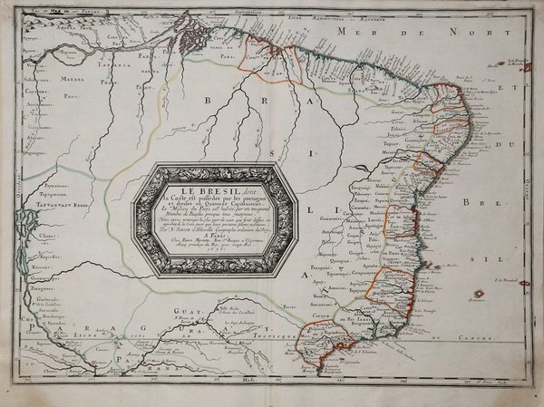
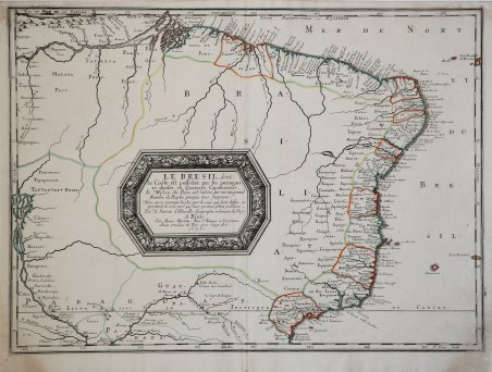
Le Bresil, dont le Coste est possedée par les portugais et divisée en Qutorze Capitanieries…
Le Bresil, dont le Coste est possedée par les portugais et divisée en Qutorze Capitanieries…
Payment methods
- PayPal
- Credit card
- Bank transfer
- Pubblica amministrazione
- Carta del Docente
Details
- Year of publication
- 1656
- Place of printing
- Parigi
- Size
- 540 X 395
- Engravers
- SANSON Nicolas
- Inscription description
- Pastoureau, Sanson V A/95; Phillips, Atlases, 4260, no. 95
Description
Mappa del Brasile realizzata da Nicolas Sanson, dalla prima edizione dell'atlante 'Amérique en plusieurs cartes, et en divers traittés de Géographie, et d'Histoire.La mappa si estende dall'Amazzonia alla zona appena a sud di Rio de Janeiro e, verso ovest, fino a Tapuaguazo e Lago de los Xarayes.Tratta dall'edizione del "Cartes Gènerales de toutes les parties du Monde" curata da Pierre Mariette, edita nel 1663. Sanson era il più famoso cartografo francese della storia moderna, cosmografo al servizio di Luigi XIV, re di Francia; dotò le sue mappe delle più recenti informazioni geografiche e delle incisioni più belle e acute del periodo. Il "Cartes Generales de Toutes les Parties du Monde" rappresenta il più importante prodotto della cartografia commerciale francese del diciassettesimo secolo.Le mappe furono compilate a partire dal 1630 e l'atlante edito per la prima volta nel 1654, stampato da Pierre Mariette. Incisione su rame, coloritura coeva dei confini, in ottimo stato di conservazione. Map of Brazil, in its first edition, 1656, published in the atlas L'Amérique en plusieurs cartes, et en divers traittés de Géographie, et d'Histoire.The map extending from the Amazon to the area just South of Rio de Janeiro and extending west to Tapuaguazo and Lago de R. los Xarayes.Map taken from "Cartes Gènerales de toutes les parties du Monde" by Sanson.The maps were compiled by Nicolas Sanson who published his atlas in 1654, with 100 maps, and printed by Pierre Mariette; they were issued progressively from 1630. Sanson was the most noted French cartographer in modern history. Mapmaker to Louis XIV, King of France, Sanson endowed his maps with the most recent geographical information as well as the finest and sharpest engraving of the period. His "Cartes Generales de Toutes les Parties du Monde" was the most important single product of French commercial cartography of the seventeenth century.Copper engraving, outline in contemporary old colors, in very good condition. Cfr. Pastoureau, Sanson V A/95; Phillips, Atlases, 4260, no. 95