Liesena, Insula della Dalmatia.
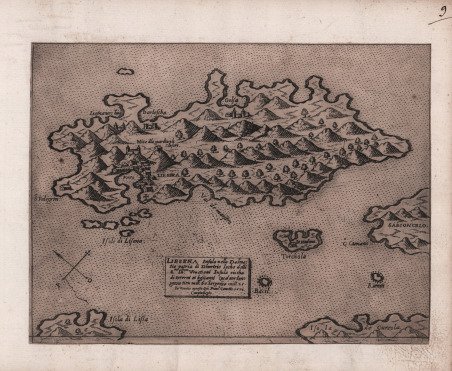

Liesena, Insula della Dalmatia.
Payment methods
- PayPal
- Credit card
- Bank transfer
- Pubblica amministrazione
- Carta del Docente
Details
- Year of publication
- 1571
- Place of printing
- Venezia
- Size
- 210 X 157
- Engravers
- CAMOCIO Giovanni Francesco
Description
In basso al centro, in un riquadro, si legge: LIESENA Insula della Dalmatia patria di Demetrio locho delli S.ri Ill.mi Venetiani Insula ricca di terreni et bestiami Qual per longezza tien mill: 60. largezza mill. 25. In Venetia apresso Gio. Franc.o Camotio 1571. Cum privilegio. Orientazione fornita da una rosa dei venti, con il nord-est in alto. Priva di scala grafica. Carta dell’isola di Hvar (it. Lesina), nella Croazia meridionale. Le fonti della carta sono da ricercare nei modelli gastaldini e nella mappa della Dalmazia del Camocio stesso. Appartiene al corpus di opere dell’editore asolano che confluisce nelle varie edizioni della raccolta Isole Famose. Camocio, nato nella prima metà del secolo XVI probabilmente ad Asolo, si trasferì poi a Venezia, dove la sua attività editoriale e registrata dal 1552, anno in cui ottenne dal Doge un privilegio di quindici anni per la pubblicazione di due volumi di alcuni scritti di autori greci in traduzione latina. Era proprietario della libreria Al segno della Piramide a San Lio in Merceria, dove la sua attività principale era la vendita di stampe e incisioni, riproduzioni calcografiche di opere d’arte e carte geografiche. Il disegno di una piramide su quattro sfere, poggiata su un piedistallo con il motto Prudentia perpetuat e la testa di un serpenterappresentano la sua marca tipografica. Si suppone che l’editore sia morto intorno al 1575, perché dopo questa data, che corrisponde poi all’anno di diffusione di una grave pestilenza a Venezia, non si hanno più notizie della sua attività. Furono molte le carte di piccolo formato, pubblicate sciolte tra il 1566 e il 1574, che confluirono nella raccolta Isole famose, porti, fortezze e terre maritime. L’opera di Camocio nasce come una raccolta di carte sciolte, principalmente relative al 1570-71 circa, molte delle quali descrivono i territori veneziani nei Balcani e in Grecia. La produzione di piccole mappe nel biennio crebbe a dismisura; le opere furono prodotte in gran parte per documentare le scorribande turche nel Mediterraneo, con i tentativi di attacco, gli assedi, le battaglie che coinvolsero le fortezze veneziane sulle coste balcaniche e le principali isole della Grecia durante la cosiddetta Guerra di Cipro (1570-73, cfr. Brummet, Mapping the Ottomans, 2015). Le prime stesure della raccolta camociana sono prive del numero ordinale, e si trovano spesso legate in volumi di piccolo formato, privi del frontespizio. Non e assolutamente raro trovare le piccole incisioni anche in raccolte fattizie cinquecentesche di grande formato, spesso stampate due per foglio. Esemplare nel primo stato di due, avanti la numerazione, impresso su carta vergata coeva, rifilato al rame ed applicato su supporto coevo, in ottimo stato di conservazione. ' Bibliografia Bifolco-Ronca (2018), Cartografia e topografia italiana del XVI secolo, p. 1346, tav. 602 I/II; Gallo (1950): p. 97, n. 15; Novak (2005): p. 305, fig. 12; Tolias (2011): n. 0364. In the lower center, in a box, we read: LIESENA Insula della Dalmatia patria di Demetrio locho delli S.ri Ill.mi Venetiani Insula ricca di terreni et bestiami Qual per longezza tien mill: 60. largezza mill. 25. In Venetia apresso Gio. Franc.o Camotio 1571. Cum privilegio. Orientation provided by a wind rose, with northeast at the top. Without graphic scale. Map of the island of Hvar, in southern Croatia. The sources of the map are to be found in the Gastaldic models and in Camocio's own map of Dalmatia. It belongs to the corpus of works of the Asolo publisher that flows into the various editions of the collection Isole famose, porti, fortezze e terre maritime. Camocio, born in the first half of the sixteenth century probably in Asolo, then moved to Venice, where his publishing activity and recorded since 1552, the year in which he obtained from the Doge a privilege of fifteen years for the publication of two volumes of some writings of Greek authors in Latin translation. He was the owner of the bookshop Al segno della Piramide in San Lio in Merceria, where his main activity was the sale of prints and engravings, intaglio reproductions of works of art and maps. The design of a pyramid on four spheres, resting on a pedestal with the motto Prudentia perpetuat and the head of a serpenterappresent his typographical mark. It is assumed that the publisher died around 1575, because after this date, which corresponds to the year of the spread of a serious plague in Venice, there is no more news of his activity. There were many papers of small format, published loose between 1566 and 1574, which came together in the collection Isole famose, porti, fortezze e terre maritime. Camocio's work began as a collection of loose charts, mainly relating to about 1570-71, many of which described Venetian territories in the Balkans and Greece. The production of small maps in the two-year period grew by leaps and bounds; the works were produced largely to document Turkish incursions into the Mediterranean, with attempted attacks, sieges, and battles involving Venetian fortresses on the Balkan coast and the main islands of Greece during the so-called War of Cyprus (1570-73, see Brummet, Mapping the Ottomans, 2015). The earliest issues of the Camocian collection lack the ordinal number, and are often found bound in small-format volumes, lacking the title page. It is not at all uncommon to find the small engravings also in sixteenth-century factitious collections of large format, often printed two per sheet. Exemple in the first state of two, before the number, printed on contemporary laid paper, trimmed to the copperplate and applied to contemporary support, in excellent condition. ' Bibliografia Bifolco-Ronca (2018), Cartografia e topografia italiana del XVI secolo, p. 1346, tav. 602 I/II; Gallo (1950): p. 97, n. 15; Novak (2005): p. 305, fig. 12; Tolias (2011): n. 0364. Cfr.