Lisbona
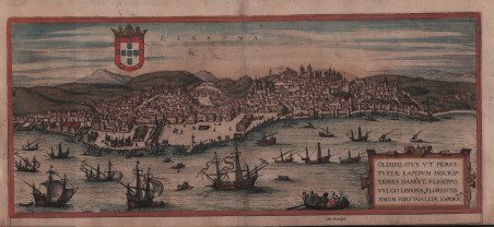

Lisbona
Payment methods
- PayPal
- Credit card
- Bank transfer
- Pubblica amministrazione
- Carta del Docente
Details
- Year of publication
- 1572
- Place of printing
- Anversa
- Size
- 500 X 230
- Engravers
- BRAUN & Franz HOGENBERG Georg
- Inscription description
- Van der Krogt 4, 2412, State 2; Taschen, Braun and Hogenberg, p.50.
Description
Veduta panoramica di Lisbona dal mare. L'apparizione di Lisbona al secondo posto delle Civitates non è certo casuale, dal momento che all'inizio del XVI secolo Lisbona contava già 350.000 abitanti ed era quindi tra le città più grandi tra quelle più famose. Le case densamente affollate nell'incisione sottolineano questo fatto. L'enfasi è posta anche sul porto e sui cantieri navali, sottolineando l'importanza di Lisbona come centro cosmopolita del commercio. Lisbona è stata la città portoghese che ha tratto i maggiori benefici dall'espansione dell'impero globale portoghese, iniziata nel 1499 dopo i viaggi di scoperta di Vasco da Gama e che ha portato alle colonie in Asia e in Sud America. Anche Papa Alessandro VI sottolineò l'importanza del Portogallo con l'incoronazione di Manuele I come "Signore della conquista, della navigazione e del commercio dell'India, dell'Etiopia, dell'Arabia e della Persia". (Taschen) L’opera è inserita nel ' Civitates Orbis Terrarum, il primo atlante devoto esclusivamente alle piante e vedute delle principali città del mondo. Il primo volume delle ' Civitates Orbis Terrarum ' fu pubblicato a Colonia nel 1572. Il sesto e ultimo volume apparve nel 1617. Questo grande atlante di città – cartografia urbana - curato da Georg Braun e inciso in gran parte da Franz Hogenberg, conteneva 546 prospettive, vedute a volo d'uccello e vedute cartografiche di città di tutto il mondo. Franz Hogenberg realizzò le tavole dei primi quattro volumi e Simon van den Neuwel (Novellanus, attivo dal 1580) quelle dei volumi V e VI. Georg Braun (1541-1622), un ecclesiastico di Colonia, fu il principale redattore dell'opera e fu molto aiutato nel suo progetto dalla vicinanza e dal continuo interesse di Abraham Ortelius, il cui ' Theatrum Orbis Terrarum ' del 1570 fu, come raccolta sistematica e completa di mappe di stile uniforme, il primo vero atlante. Le ' Civitates, ' in effetti, erano destinate ad accompagnare il ' Theatrum, ' come indicato dalla somiglianza dei titoli e dai riferimenti contemporanei sulla natura complementare delle due opere. Tuttavia, le ' Civitates ' erano progettate per avere un approccio più popolare, senza dubbio perché la novità di una raccolta di piante e vedute di città rappresentava un'impresa commerciale più rischiosa di un atlante mondiale, per il quale c'erano stati diversi precedenti di successo. Franz Hogenberg (1535-1590) era figlio di un incisore di Monaco che si era stabilito a Malines. Incise la maggior parte delle tavole del ' Theatrum ' di Ortelius e la maggior parte di quelle delle ' Civitates, e potrebbe essere anche indicato come il responsabile dell'origine del progetto. Oltre un centinaio di artisti e cartografi diversi, il più importante dei quali fu l'artista di Anversa Georg Hoefnagel (1542-1600), fornirono i disegni per le tavole delle ' Civitates. Hoefnagel non solo contribuì alla maggior parte del materiale originale per le città spagnole e italiane, ma rielaborò e modificò anche quello di altri collaboratori. Dopo la morte di Hoefnagel, il figlio Jakob continuò il lavoro per le ' Civitates. Gli autori della raccolta si proponevano di raffigurare "non icones et typi urbium", cioè non immagini generiche e tipizzate, "sed urbes ipsae admirabili caelaturae artificio, spectantium oculis subiectae appareant": non intendeva alludere o idealizzare, ma rappresentare fedelmente sulla carta, riprodurre esattamente, e in tempo reale, ciò che l'occhio vede, come annunciato nella prefazione al primo volume delle ' Civitates Orbis Terrarum. Incisione in rame finemente acquarellata, in ottimo stato di conservazione. A panoramic view of Lisbone. "Lisbon's appearance in second place in the Civitates is certainly no accident, since by the start of the 16th century Lisbon already numbered 350,000 inhabitants and thus ranked amongst the largest of all the most famous cities. The densely packed houses in the engraving underline this fact. Emphasis is also placed upon the harbour and shipyards, highlighting Lisbon's importance as a cosmopolitan centre of trade. Lisbon was the Portuguese city that profited the most from the expansion of the Portuguese global empire, which began in 1499 after Vasco da Gama's voyages of discovery and led to the colonies in Asia and South America. Pope Alexander VI also underlined Portugal's importance with the coronation of Manuel I as "Lord of the conquest, navigation and commerce of India, Ethiopia, Arabia and Persia". (Taschen) The work is included in the ' Civitates Orbis Terrarum, the first atlas devoted exclusively to plans and views of the world's major cities. Printed in six volumes between 1572 and 1617 it was so successful and widespread that several editions translated into Latin, German and French were printed. The first volume of the ' Civitates Orbis Terrarum ' was published in Cologne in 1572. The sixth and the final volume appeared in 1617. This great city atlas, edited by Georg Braun and largely engraved by Franz Hogenberg, eventually contained 546 prospects, bird-eye views and map views of cities from all over the world. Fransz Hogenberg produced the plates for the first four books, and Simon van den Neuwel (Novellanus, active since 1580) those for volumes V and VI. Georg Braun (1541-1622), a cleric of Cologne, was the principal editor of the work, and was greatly assisted in his project by the close, and continued interest of Abraham Ortelius, whose ' Theatrum Orbis Terrarum ' of 1570 was, as a systematic and comprehensive collection of maps of uniform style, the first true atlas. The ' Civitates, ' indeed, was intended as a companion for the ' Theatrum, ' as indicated by the similarity in the titles and by contemporary references regarding the complementary nature of two works. Nevertheless, the ' Civitates ' was designs to be more popular in approach, no doubt because the novelty of a collection of city plans and views represented a more hazardous commercial undertaking than a world atlas, for which there had been a number of successful precedents. Franz Hogenberg (1535-1590) was the son of a Munich engraves who settled in Malines. He engraved most of the plates for Ortelius's ' Theatrum ' and the majority of those in the ' Civitates, and may have been responsible for originating the project. Over a hundred of different artists and cartographers, the most significant of whom was Antwerp artist Georg Hoefnagel (1542-1600), engraved the cooper-plates of the ' Civitates ' from drawings. He not only contributed most of the original material for the Spanish and Italian towns but also reworked and modified those of other contributors. After Hoefnagel's death his son Jakob continued the work for the Civitates. The author set out to depict "non icones et typi urbium," that is, not generic and typified images, "sed urbes ipsae admirabili caelaturae artificio, spectantium oculis subiectae appareant": not intended to allude or idealize but to represent faithfully on paper, to reproduce exactly, and in real time, what the eye sees, as announced in the preface to the first volume of ' Civitates Orbis Terrarum. Copper engraving, in very good condition. Cfr. Van der Krogt 4, 2412, State 2; Taschen, Braun and Hogenberg, p.50.