Prints
Otto Petri, 1853
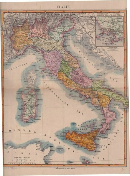
Mappa dell'Italia, 1853
1853
unavailable
La Puntasecca Stampe Studio Bibliografico (Napoli, Italy)
Ask for more infoThe correct shipping costs are calculated once the shipping address is entered during order creation. One or more delivery methods are available at the Seller's own discretion: Standard, Express, Economy, In-store pick-up.
Bookshop shipping conditions:
For items priced over €300, it is possible to request an instalment plan from Maremagnum. Payment can be made with Carta del Docente, Carta della cultura giovani e del merito, Public Administration.
Delivery time is estimated according to the shipping time of the bookshop and the courier. In case of customs detention, delivery delays may occur. Any customs duties are charged to the recipient.
For more infoPayment methods
- PayPal
- Credit card
- Bank transfer
-

-
 Find out how to use
your Carta del Docente -
 Find out how to use
your Carta della cultura giovani e del merito
Details
Description
Italie. Carta geografica colorata in epoca coeva; misura del foglio cm.34x26, su carta forte, retro bianco, piega editoriale; ottime condizioni; tratta da School Atlas Alle Deelen Der Aarde , J. Van Den Bosch, Rotterdam, Otto Petri, 1853.