Mappemonde en deux Hémispherès
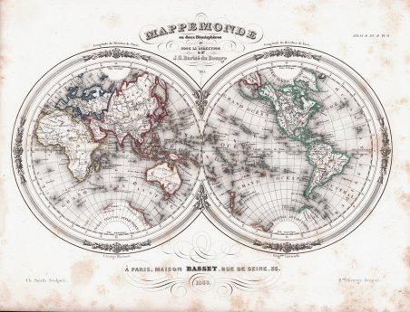
Mappemonde en deux Hémispherès
Payment methods
- PayPal
- Credit card
- Bank transfer
- Pubblica amministrazione
- Carta del Docente
Details
- Year of publication
- 1848
- Place of printing
- Parigi
- Size
- 320 X 230
- Engravers
- Barbié du Bocage Jean-Denis
Description
Attraente carta del mondo in due emisferi di Jean-Guillaume Barbie du Bocage. Mostra le rivendicazioni degli Stati Uniti sulla Columbia Britannica. L'Australia è indicata come “Nouvelle Hollande” e “inconnus”. L'Africa è in gran parte inesplorata ed e descritta come “pays inconnous”. Le coste dell'Antartide sono disegnate in modo sommario sulla base delle prime spedizioni. Preparata da Barbie du Bocage per essere pubblicata nell'edizione del 1848 dell'Atlas Illustre pubblicato dalla casa editrice Maison Basset. La Maison Basset (1819 - 1865) è stata un'azienda editoriale francese attiva nella metà e nella fine del XIX secolo, fondata da André Basset (o Bassett), che iniziò a pubblicare mappe, stampe e libri intorno al 1768. La Maison Basset, o Chez Basset, è il marchio con cui gli eredi di Paul-André Basset (1785-1819) pubblicarono le opere di importanti cartografi e incisori francesi come Barbie du Bocage, A. Vuillemin, J. B. Charle, V. Levasseur, Tu. Duvotenay, H. Dufor, F. E. George e altri. La loro biblioteca di pubblicazioni è varia e vasta, ma fortemente incentrata su testi medici e scientifici, tra cui alcuni importanti atlanti. Jean Denis Barbie du Bocage (1760 - 1825) e suo figlio Jean-Guillaume Barbie du Bocage (1795 - 1848) furono cartografi e cosmografi francesi attivi a Parigi tra la fine del XVIII e l'inizio del XIX secolo. Il più anziano dei Barbie du Bocage, Jean Denis, si formò come cartografo e incisore nei laboratori di J. B. B. d'Anville. Jean Denis ricoprì la carica di Bibliotecario Reale di Francia, mentre Jean-Guillaume divenne Geographe du Ministere des Affaires Etrangeres. Incisione in rame con contorno originale a colori, alcune ossidazioni, per il resto buono stato di conservazione. An attractive 1843 map of the world in hemispheres by Jean-Guillaume Barbie du Bocage. Shows United States claims to British Columbia. Australia is labeled 'Nouvelle Hollande' and 'inconnus.' Africa to is largely unexplored and is labeled 'pays inconnous.' The coast of Antarctica is drawn in sketchily based upon early expeditions. Features a beautiful frame style border. Prepared by Barbie du Bocage for publication as plate no. 2 in Maison Basset's 1848 edition of the Atlas Illustre. Maison Basset (1819 - 1865) was a French publishing concern active through the mid to late 19th century. The firm can trace their roots to André Basset (or Bassett) (fl. 1768 - 1784), who starting publishing maps, prints, and books around 1768. Maison Basset, also Chez Basset, is the imprint under which the heirs of Paul-André Basset (1785 - 1819) published the works of such prominent French cartographers and engravers as Barbie du Bocage, A. Vuillemin, J. B. Charle, V. Levasseur, Tu. Duvotenay, H. Dufor, F. E. George, and others. Their library of publications is diverse and vast, but heavily focused on medical and scientific texts, including several important atlases. Jean Denis Barbie du Bocage (1760 - 1825) and his son Jean-Guillaume Barbie du Bocage (1795 - 1848) were French cartographers and cosmographers active in Paris in the late 18th and early 19th centuries. The oldest of the Barbie du Bocage, Jean Denis, trained as a cartographer and engraver in the workshops of J. B. B. d'Anville. Jean Denis held the position of Royal Librarian of France while Jean-Guillaume became Geographe du Ministere des Affaires Etrangeres. Copper engraving with original outline colour, some foxing, otherwise good condition. Cfr.