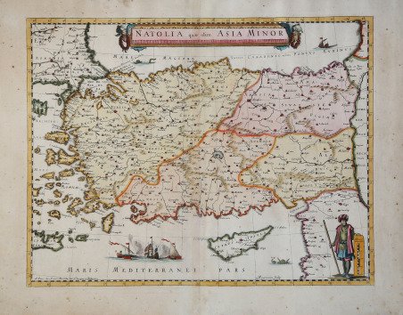
Natolia quae olim Asia Minor
Natolia quae olim Asia Minor
Payment methods
- PayPal
- Credit card
- Bank transfer
- Pubblica amministrazione
- Carta del Docente
Details
- Year of publication
- 1646
- Place of printing
- Parigi
- Size
- 490 X 375
- Engravers
- MARIETTE Pierre
Description
Copre la Turchia moderna, Cipro e diverse isole dell'Egeo. Mappa incisa in rame da Abraham Peyrounin e pubblicata da "Pierre Mariette, rue St. Jacques a l'Esperance", Parigi verso il 1650. Al verso nessun testo. Plagio (copia) non comune della mappa della Natolia di Blaeu (Koeman-v.d.Krogt 8110; Zacharakis/Scutari 388). È noto che Mariette commissionò a Peyrounin a partire dal 1646 l'incisione di copie di mappe olandesi per la sua casa editrice (cfr. Pastoureau, Les Atlas Francais, p. 345). Ma Pastoureau non menziona questa carta tra quelle contenute negli atlanti di Pierre Mariette. Questa è una ragione per credere che potrebbe essere una carta sciolta stampata senza autorizzazione. ' La produzione cartografica di Mariette deriva principalmente dall’opera di Nicolas Sanson, con il quale Pierre Mariette "il vecchio" e suo figlio Pierre "il giovane" (1634-1716) collaborarono per la stesura del celebre Cartes Genèrales de toutes les parties du Monde. Alcune carte, edite in un secondo momento, come la presente, direttamente da Mariette, vengono ricavate da modelli diversi; in questo caso è evidente la derivazione ricavata dagli atlanti olandesi, data la sua collaborazione con gli editori di Amsterdam, in particolare con Blaeu e Janssonius. Incisione in rame, finemente colorata a mano, in perfette condizioni. Rara. It covers Turkey from the Aegean Sea east as far as the Euphrates River. Cyprus and some of the Aegean Islands are also included. The map is beautifully detailed, noting several important towns, cities, rivers, and topography. Mountains are beautifully rendered in profile. The important cities of Constantinople (Istanbul), Smyrna (Izmir) and Antioch are identified. The Ottoman Empire, at its peak, controlled the entire region during this period with Constantinople as its capital. In the middle part of the 17th century, after its period of growth, the Ottoman Empire would enter a period of gradual decline and stagnation. Copper engraved map with fine colour, engraved by Abraham Peyrounin and published by “Pierre Mariette , rue St. Jacques a l’Esperance”, Paris c. 1650. Verso no text. Uncommon plagiarism of Blaeu’s Natolia-Map (Koeman-v.d.Krogt 8110; Zacharakis/Scutari 388). It is well known, that Mariette commissioned Peyrounin from 1646 onwards to engrave copies of Dutch maps for his own publishing house (cf. Pastoureau, Les Atlas Francais, p. 345). But Pastoureau does not mention our map as an Atlas map. That is reason to believe, that our Mariette Natolia might be a single printed map. Mariette's cartographic production derives mainly from the work of Nicolas Sanson, with whom Pierre Mariette "the old" and his son Pierre "the young" (1634-1716) collaborated in the famous Cartes Genèrales de toutes les parties du Monde. Some maps, published at a later date, such as this one, directly by Mariette, are derived from different models; in this case the derivation from Dutch atlases is evident, given his collaboration with the Amsterdam publishers, in particular with Blaeu and Janssonius. Copper engraving, finely hand-colored, in perfect condition. Rare. Cfr.