Niewe Kaart van Italien met de gemene wegen en Postwegen…
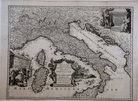
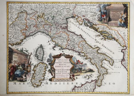
Niewe Kaart van Italien met de gemene wegen en Postwegen…
Payment methods
- PayPal
- Credit card
- Bank transfer
- Pubblica amministrazione
- Carta del Docente
Details
- Year of publication
- 1700
- Place of printing
- Amsterdam
- Size
- 660 X 550
- Engravers
- HALMA Franciscus
- Languages
- Italian
Description
ITALIA CUM STATIONIBUS ET VIIS PUBLICIS DELINEATA A JACOBO CANTELLI DA VIGNOLA, ECC. AMSTELODAMI EXUDIT F. HALMA, ECC. IN USUM SERENISS. PRINCIPIS BORUSSIAE. Carta geografica e postale della penisola, deriva da quella di Giacomo Cantelli ed è edita per la prima volta a Leida da Pieter Vander Aa nel 1700. Come si ricava dai due titoli in olandese e latino, trattasi di una derivazione olandese della carta di Giacomo Cantelli da Vignola, edita da Francesco Halma ad Amsterdam, e dedicata al Principe Federico Guglielmo. Longitudini provenienti dalle isole di Capo Verde e orografia prospettica. Le strade sono rappresentate con due linee parallele; pure in rosso sono i centri principali. Incisa da G. Droogenham.Sono conosciuti diversi stati della lastra, uno senza il titolo nel cartiglio in alto a destra in olandese (qui presente) ed uno con uno stemma araldico dei principali stati italiani, contenuto sempre nel medesimo cartiglio.Esemplare tratto dall'opera Beschryving van oud en nieuw Rome, di François Jacques Deseine edita ad Amsterdam nel 1704 da Franz Halma.Acquaforte, ' finemente colorata a mano, in ottimo stato di conservazione. ITALIA CUM STATIONIBUS ET VIIS PUBLICIS DELINEATA A JACOBO CANTELLI DA VIGNOLA, ECC. AMSTELODAMI EXUDIT F. HALMA, ECC. IN USUM SERENISS. PRINCIPIS BORUSSIAE. Geographical and postal map of Italy, derived from that of Giacomo Cantelli and first published in Leiden by Pieter Vander Aa in 1700. As can be deduced from the two titles in Dutch and Latin, it is a Dutch derivation of the map by Giacomo Cantelli da Vignola, published by Franz Halma in Amsterdam, and dedicated to Prince Frederick William. Longitudes from the Cape Verde Islands and perspective orography. The streets are represented with two parallel lines; also in red are the main centres. Engraved by G. Droogenham. Several states of the plate are known, one without the title in the upper right cartouche in Dutch (present here) and one with a heraldic coat of arms of the main Italian states, also contained in the same cartouche. Exemplar from the work Beschryving van oud en nieuw Rome, by François Jacques Deseine published in Amsterdam in 1704 by Franz Halma. Etching, finely hand-coloured, in excellent condition. Cfr. Borri, L'Italia nelle carte geografiche, n. 178