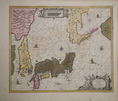
Nova et Accurata Iaponiae Terrae esonis ac Insularum adjacentium
Nova et Accurata Iaponiae Terrae esonis ac Insularum adjacentium
Payment methods
- PayPal
- Credit card
- Bank transfer
- Pubblica amministrazione
- Carta del Docente
Details
- Year of publication
- 1658
- Place of printing
- Amsterdam
- Size
- 545 X 450
- Engravers
- JANSSONIUS Johannes
- Inscription description
- Walter, Japan a Cartographic vision, p. 193, 57; Cortazzi p. 70. Dimensioni 550x455.
Description
Per la prima volta pubblicata nel Atlas Novus del 1644, la carta di Giappone e Corea del Janssonius venne aggiornata nella nuova edizione, implementata da numerose mappe, del 1657. Egli colse l’opportunità di apportare alcune modifiche, basate sulle nuove esplorazioni di Maarten Vries del 1643. La forma del Giappone pertanto mutò, riducendo la larghezza dell’isola, nuovi toponimi furono inseriti e diversamente posizionati. Tuttavia sono presenti molti errori di collocazione geografica; clamorosa la descrizione di Iedo (erroneamente denominata Iede), molto a Nord. Il nostro esemplare, privo del testo al verso, deriva probabilmente da un atlante composito edito dagli eredi di Janssonius verso il 1680. Dal 1694 la lastra fu acquistata da Valck & Schenk, che sostituirono l’indirizzo di Janssonius con il loro. Joannes Janssonius, figlio dell'editore di Arnhem Jan Janssen, sposò Elisabeth Hondius, figlia di Jodocus Hondius, ad Amsterdam nel 1612. Dopo il suo matrimonio, si stabilì in questa città come libraio ed editore di materiale cartografico. Nel 1618 si stabilì ad Amsterdam accanto alla libreria di Willem Jansz. Blaeu, entrando in una seria competizione. Le sue attività non riguardavano solo la pubblicazione di atlanti e libri, ma anche di mappe singole e un vasto commercio di libri con filiali a Francoforte, Danzica, Stoccolma, Copenaghen, Berlino, Koningsbergen, Ginevra e Lione. Nel 1631 iniziò a pubblicare atlanti insieme a Henricus Hondius. Nei primi anni 1640 Henricus Hondius lasciò l'attività di pubblicazione di atlanti completamente a Janssonius. La concorrenza con Joan Blaeu, figlio e successore di Willem, nella produzione di atlanti spinse Janssonius ad ampliare il suo ' Atlas Novus ' finalmente in un'opera di sei volumi, in cui furono inseriti un atlante marino e un atlante del Vecchio Mondo. Dopo la morte di Joannes Janssonius, il negozio e la casa editrice furono continuati dagli eredi sotto la direzione di Johannes van Waesbergen (c. 1616-1681), genero di Joannes Janssonius. Le matrici degli atlanti di Janssonius furono in seguito vendute a Schenk e Valck. “Janssonius's work resembles a navigation chart due to the rhumb lines and compass roses it contains. The mileage chart gives the detail on the increasing scale of the Mercator projection. Campbell (1967) writes that it was based on the chart "compiled by Maerten de Vries on his voyage of 1643" and goes on to explain that the depiction of Staten Eyland and Compagnies Land was a greatly exaggerated depiction of two of the Kuril islands. Also, Hokkaid?, here shown as Landt van Eso, appears to be connected to the Asian continent. This map of Japan appears for the first time in the third volume of the German language Novus Atlas and was later incorporated in his Atlas Maior from 1675. Janssonius died in 1664, and his heirs continued the business until 1676 when the atlas inventory was sold to Abraham Wolfgang along with some of the copperplates which were later sold on to Schenk and Valck. A second auction of the remaining copperplates took place in 1694. It is not certain exactly when Schenk and Valck acquired the copperplate for this map, the rough estimated date being c.1700. Schenk and Valck erased Janssonius's imprint and replaced it with their own. The map was then sold either loose or for inclusion in a number of composite atlases over the next three or four decades." (Hubbard "Japoniae Insulae – The Mapping of Japan", p. 203). Incisione in rame, magnifica coloritura coeva, in ottimo stato di conservazione. ' Bibliografia: Hubbard "Japoniae Insulae – The Mapping of Japan", pp. 203-204, n. 30; Walter “Japan a Cartographic vision”, p. 193, n. 57; Cortazzi p. 70. Showing Japan and part of China. First published in 1644 in Janssonius' Novus Atlas. From 1657 Janssonius (Jan Jansen) supplemented the folio-edition of his atlas with several maps. He took the opportunity to enlarge the scale of this new map of Japan. Older maps depicted Ezo much larger than it is after Vries, in 1643, mistook Kunashiri and Urup to be parts of Ezo. This map shows Urup, which Vries called Compagnijs Landt, to be much larger than it was depicted before. Jansonius used the additional space to enlarge the scale and add placenames. However, he made many mistakes in the placenames and depicted many places at a wrong position, for example he called Iedo Iede and placed it to far to the north. This example, printed without text, was very likely included in an atlas published by the heirs of Janssonius towards 1680. In 1694 the plate was bought by Valck & Shenk, who put their address on it. Joannes Janssonius (Arnhem, 1588-1664), son of the Arnhem publisher Jan Janssen, married Elisabeth Hondius, daughter of Jodocus Hondius, in Amsterdam in 1612. After his marriage, he settled down in this town as a bookseller and publisher of cartographic material. In 1618 he established himself in Amsterdam next door to Blaeu’s book shop. He entered into serious competition with Willem Jansz. Blaeu. His activities not only concerned the publication of atlases and books, but also of single maps and an extensive book trade with branches in Frankfurt, Danzig, Stockholm, Copenhagen, Berlin, Koningsbergen, Geneva, and Lyon. In 1631 he began publishing atlases together with Henricus Hondius. In the early 1640s Henricus Hondius left the atlas publishing business completely to Janssonius. Competition with Joan Blaeu, Willem’s son and successor, in atlas production prompted Janssonius to enlarge his ' Atlas Novus ' finally into a work of six volumes, into which a sea atlas and an atlas of the Old World were inserted. After the death of Joannes Janssonius, the shop and publishing firm were continued by the heirs under the direction of Johannes van Waesbergen (c. 1616-1681), son-in-law of Joannes Janssonius. The copperplates from Janssonius’s atlases were afterwards sold to Schenk and Valck. “Janssonius's work resembles a navigation chart due to the rhumb lines and compass roses it contains. The mileage chart gives the detail on the increasing scale of the Mercator projection. Campbell (1967) writes that it was based on the chart "compiled by Maerten de Vries on his voyage of 1643" and goes on to explain that the depiction of Staten Eyland and Compagnies Land was a greatly exaggerated depiction of two of the Kuril islands. Also, Hokkaid?, here shown as Landt van Eso, appears to be connected to the Asian continent. This map of Japan appears for the first time in the third volume of the German language Novus Atlas and was later incorporated in his Atlas Maior from 1675. Janssonius died in 1664, and his heirs continued the business until 1676 when the atlas inventory was sold to Abraham Wolfgang along with some of the copperplates which were later sold on to Schenk and Valck. A second auction of the remaining copperplates took place in 1694. It is not certain exactly when Schenk and Valck acquired the copperplate for this map, the rough estimated date being c.1700. Schenk and Valck erased Janssonius's imprint and replaced it with their own. The map was then sold either loose or for inclusion in a number of composite atlases over the next three or four decades." (Hubbard "Japoniae Insulae – The Mapping of Japan", p. 203). Copper engraving, magnificent contemporary colour, in excellent condition. ' Bibliografia: Hubbard "Japoniae Insulae – The Mapping of Japan", pp. 203-204, n. 30; Walter “Japan a Cartographic vision”, p. 193, n. 57; Cortazzi p. 70. ' Cfr.