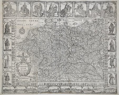
Nova Germaniae descriptio. Amstelodami apud Ioannem Ianssoniu[m] anno 1660. Eccellente carte-à-figures della Germania, comprendente anche parte delle Fiandre e di Svizzera, Italia, Polonia, Boemia e Ungheria, oltre che la raffigurazione delle principali città e borghi. Si tratta di una copia pirata della mappa di Pieter van der Keere (Kaerius) del 1615, esattamente della sua terza edizione pubblicta nel 1631 da Johannes Janssonius (cfr. Schilder MCN, VI, n. 33.3). Le vignette lungo i margini destro e sinistro raffigurano diversi modelli regionali e sociali, mentre quelle lungo i margini superiore e inferiore raffigurano vedute e piante delle città tedesche situate lungo i confini. Nel margine superiore è inserito anche un ritratto equestre di Ferdinando II, Santo Imperatore Romano e Re di Boemia, insieme ad altri duchi e arcivescovi con i loro rispettivi stemmi araldici nella parte superiore. Gunther Shilder, nell'introduzione alla sua cartobibliografia delle carte olandesi in folio con bordi decorativi (talvolta definite carte-à-figures, o “carte a pannelli”), ha commentato: “questo genere deve essere considerato uno dei migliori prodotti dell'industria cartografica di Amsterdam. La combinazione vincente tra i progressi delle conoscenze geografiche e l'espressione delle capacità artistiche fece di queste mappe un bene prezioso sia sul mercato nazionale che su quello internazionale” (cfr. Günter Schilder, Monumenta Cartographica Neerlandici VI. "Nederlandse foliokarten met decoratieve randen, 1604-1640”. Il fatto che molte di queste mappe venissero vendute in fogli separati e inserite solo casualmente negli atlanti compositi dell'epoca ne spiega la rarità odierna, mentre il loro fascino estetico non è diminuito nel corso dei secoli, rendendole esempi altamente collezionabili dell'arte cartografica. Questa carta della Germania era ignota a Klaus Stopp, riconosciuto come la maggiore autorità in materia di carte-à-figures. Un esemplare di questa mappa (e di altre anonime carte-à-figures italiane) privo di data ed indicazioni editoriali è stato venduto all’asta, presso Sotheby's Londra, nel novembre del 2008 (lotto 162 e seguenti). Il catalogatore (all’epoca Catherine Slowther, Sotheby’s Senior Specialist), seppure in maniera dubitativa, attribuì la carta a Stefano Mozzi Scolari, datandola al 1642 circa. L’ipotesi, più che attendibile, veniva basata sulla carta utilizzata per la mappa, una carta italiana come documentato dalla presenza della filigrana: “Seven of the maps following are hitherto unrecorded piracies taken from Dutch models by Pieter van den Keere or Jodocus Hondius Jr (re-)published by Johannes Janssonius in the 1630s and 1640s; one feature of the copying process is that the vast majority of the vignettes and costume figures, as also the armorials on the map of Germany, are reversed in engraving so what was on the left in the original now appears on the right. While this is commonly encountered for decorative features in maps, it is incongruous on the London plan, for example, to see the Tower of London placed on the west side of London and Westminster on the east. (However, all the vignettes on the map of France and three on that of Europe – Venice, Rome and Constantinople – are correctly orientated). Although copied from Dutch models, and assuming the engraved dates of 1641 or 1642 are broadly correct for the publication date of the set, it should be noted that the examples of the maps used were not acquired contemporaneously; the maps of the continents, for example were issued by Janssonius in 1632 with the lower panel removed. It is possible that these maps were engraved in Venice (the plan of Venice being one of the few vignette insets correctly orientated), perhaps by the little known publisher Stefano Scolari, who is known to have published other maps from Dutch originals, but as the maps are without any engraved attribution, this must be speculative. . Excellent map-à-figures of Germany, also including parts of Flanders and Switzerland, Italy, Poland, Bohemia and Hungary, as well as depictions of major cities and towns. This is a pirated copy of Pieter van der Keere's (Kaerius) map of 1615, exactly its third edition published in 1631 by Johannes Janssonius (see Schilder MCN, VI, no. 33.3). The vignettes along the left and right margins depict various regional and social patterns, while those along the upper and lower margins depict views and plans of German cities located along the borders. Also included in the upper margin is an equestrian portrait of Ferdinand II, Holy Roman Emperor and King of Bohemia, along with other dukes and archbishops with their respective heraldic coats of arms at the top. Gunther Shilder, in the introduction to his cartobibliography of Dutch folio maps with decorative borders (sometimes referred to as carte-à-figures, or "panel maps"), commented, "this genre must be regarded as one of the best products of the Amsterdam cartographic industry. The successful combination of advances in geographical knowledge and the expression of artistic skills made these maps a valuable commodity in both the domestic and international markets" (see Günter Schilder, Monumenta Cartographica Neerlandici VI. "Nederlandse foliokarten met decoratieve randen, 1604-1640." The fact that many of these maps were sold in separate sheets and included only casually in the composite atlases of the time explains their rarity today, while their aesthetic appeal has not diminished over the centuries, making them highly collectible examples of cartographic art. This map of Germany was unknown to Klaus Stopp, recognized as the foremost authority on carte-à-figures. A specimen of this map (and other anonymous Italian carte-à-figures) devoid of date and editorial indications was sold at auction, at Sotheby's London, in November 2008 (lot 162 et seq.). The cataloguer (at the time Catherine Slowther, Sotheby's Senior Specialist), albeit dubiously, attributed the map to Stefano Mozzi Scolari, dating it to about 1642. The hypothesis, more than reliable, was based on the paper used for the map, an Italian map as documented by the presence of the watermark: “Seven of the maps following are hitherto unrecorded piracies taken from Dutch models by Pieter van den Keere or Jodocus Hondius Jr (re-)published by Johannes Janssonius in the 1630s and 1640s; one feature of the copying process is that the vast majority of the vignettes and costume figures, as also the armorials on the map of Germany, are reversed in engraving so what was on the left in the original now appears on the right. While this is commonly encountered for decorative features in maps, it is incongruous on the London plan, for example, to see the Tower of London placed on the west side of London and Westminster on the east. (However, all the vignettes on the map of France and three on that of Europe – Venice, Rome and Constantinople – are correctly orientated). Although copied from Dutch models, and assuming the engraved dates of 1641 or 1642 are broadly correct for the publication date of the set, it should be noted that the examples of the maps used were not acquired contemporaneously; the maps of the continents, for example were issued by Janssonius in 1632 with the lower panel removed. It is possible that these maps were engraved in Venice (the plan of Venice being one of the few vignette insets correctly orientated), perhaps by the little known publisher Stefano Scolari, who is known to have published other maps from Dutch originals, but as the maps are without any engraved attribution, this must be speculative. That the paper used in printing was too small for the printing plates may, however, point to a bookseller rather than map- or print-seller. ' ' Five of the maps have watermarks showing an anchor in a circle, surmounted by a six-pointed star (Heawood 8?) which indicates the paper to be Italian and . Cfr.

 Find out how to use
 Find out how to use