Pascaert van de Middelandsche Zee, vertoonende in twee deelen, zijn van de Miswysing en veel fouten Verbetert
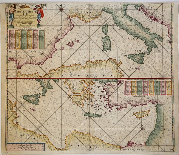
Pascaert van de Middelandsche Zee, vertoonende in twee deelen, zijn van de Miswysing en veel fouten Verbetert
Payment methods
- PayPal
- Credit card
- Bank transfer
- Pubblica amministrazione
- Carta del Docente
Details
- Year of publication
- 1682
- Place of printing
- Amsterdam
- Size
- 590 X 530
- Engravers
- VAN KEULEN Johannes
- Inscription description
- S. Bifolco, "Mare Nostrum, Cartografia nautica a stampa del Mar Mediterraneo" (2020), p. 153, tav. 65.
Description
Acquaforte e bulino, 530x590 mm, firmata in lastra nel cartiglio: T’ Amstredam By Iohannes van Keulen Boeckverkooper aende Nieubrugh in de geckroonide Lootsman Mer Privilegie voor 15 Iaaren.Bellissimo esemplare in coloritura d'epoca.Carta tratta da: De Nieuwe Groote Lichtende Zee-Fakel, ‘t Derde Deel. Verhoonde de Kunsten van Granaden, Catalonien, Provence, Italien, Dalmatien, Grieken, Thracien, Natolien, Syrien, Egyptne, en de geheele Noordkust van Barbaryen, met alle haer onderhoo rende en tussschen leggende Eylanden. […] Door Claas Jansz. Vooght, Geometra Leermeester der Wis-konst. T’ Amsterdam, Gedruckt voor Johannes van Keulen, Boeck en Zee-Kaert-verkoper, aen de Nieuw-brugh, in de gekroonde Lootsman. 1682. Met Privilegie voor 15 Jaren.Carta nautica del Mediterraneo, suddiviso in due parti, disegnata da Claes Jansz Vooght; viene per la prima volta inserita nel terzo volume del Nieuwe Lichtende Zee-Fakkel (1682) sul Mediterraneo. La tavola viene ristampata e inclusa in numerose edizioni, anche in altre lingue, dell’opera. A partire dal 1695, la tavola del Mediterraneo è inserita anche nell’altra guida nautica degli editori di Amsterdam, il De Groote Nieuwe Vermeerderde Zee-Atlas ofte Water-werelt (cfr. Koeman, AN, vol. IV, p. 293, Keu 20 B). La dinastia Van Keulen di editori, stampatori mercanti di libri e cartografi produsse i più completi e aggiornati atlanti nautici olandesi. Johannes van Keulen (1654 - 1715) nel 1678 fondò un’attività di vendita di libri e strumenti ad Amsterdam e nel 1680 ottenne il privilegio dall’Olanda e dalla Frisia occidentale di stampare guide e atlanti nautici. La sua prima grande opera fu il Nieuwe Lichtende Zee-Fakkel, illustrato da Jan Luyken, con mappe disegnate da Claes Jansz Vooght; ne furono pubblicati cinque volumi tra il 1681 e il 1684. Van Keulen produsse anche uno Zee-Atlas ofte Water-werelt. L’attività dei Van Keulen continuò per quasi due secoli; Gerard (1678 - 1726) produsse nuove edizioni delle opere del padre, numerose carte manoscritte e nel 1706 fu nominato idrografo della Compagnia olandese delle Indie Orientali (VOC); suo figlio Jan II van Keulen (1704 - 1770) rilevò l’attività nel 1726 e pubblicò una nuova edizione del volume asiatico dello Zee-Atlas; fu nominato cartografo del VOC nel 1743. Dopo la morte di Jan II, i suoi figli Cornelis Buijs e Gerard Hulst van Keulen gestirono l’attività di famiglia. Gerard (1733 - 1801) aggiunse un ulteriore volume allo Zee-Fakkel contenente materiale sulle Indie Orientali derivato dalla VOC. Gerard, oltre ad avere anche pubblicato il primo almanacco nautico in olandese nel 1788, fu uno dei tre membri originari della commissione istituita dal governo olandese nel 1787 per risolvere il problema di trovare la longitudine in mare. Il figlio di Gerard, Jan III, è stato l’ultimo van Keulen a dirigere l’azienda. Bibliografia: C. Koeman, Atlantes Neerlandici: Bibliography of Terrestrial, Maritime and Celestial Atlases and Pilot Books Published in the Netherlands up to 1880 Vol. IV, Amsterdam 1970, pp. 338-347, Keu 87 A (1) 99; National Maritime Museum, Catalogue of the Library - Vol. Three, Atlas & Cartography, Londra, 1971, pp. 110-114, n. 107 (104); cfr. R. Shirley, Maps in the Atlases of the British Library, Londra, 2004, pp. 1200-1213; cfr. D. de Vries, G. Schilder, W. Morzer Bruyns, P. van Iterson, I. Jacobs, The Van Keulen Cartography Amsterdam 1680-1885, Alphen aan den Rijn, 2005. Etching and engraving, 530x590 mm, signed in the cartouche: T ’Amstredam By Iohannes van Keulen Boeckverkooper aende Nieubrugh in de geckroonide Lootsman Mer Privilegie voor 15 Iaaren.Beautiful example in old coloring.Map taken from: De Nieuwe Groote Lichtende Zee-Fakel, ‘t Derde Deel. Verhoonde de Kunsten van Granaden, Catalonien, Provence, Italien, Dalmatien, Grieken, Thracien, Natolien, Syrien, Egyptne, en de geheele Noordkust van Barbaryen, half the haer onderhoo makes en tussschen legends Eylanden. [.] Door Claas Jansz. Vooght, Geometra Leermeester der Wis-konst. T 'Amsterdam, Gedruckt voor Johannes van Keulen, Boeck en Zee-Kaert-verkoper, aen de Nieuw-brugh, in de gekroonde Lootsman. 1682. Met Privilegie voor 15 Jaren.Nautical chart of the Mediterranean, divided into two parts, designed by Claes Jansz Vooght; it was first included in the third volume of the Nieuwe Lichtende Zee-Fakkel (1682) devoted to the Mediterranean. The plate is reprinted and included in numerous editions, also in other languages, of the atlasStarting from 1695, the Mediterranean table is also included in the other nautical guide of the editors of Amsterdam, the De Groote Nieuwe Vermeerderde Zee-Atlas ofte Water-werelt (see Koeman, AN, vol. IV, p. 293, Keu 20 B).Bibliografia: C. Koeman, Atlantes Neerlandici: Bibliography of Terrestrial, Maritime and Celestial Atlases and Pilot Books Published in the Netherlands up to 1880 Vol. IV, Amsterdam 1970, pp. 338-347, Keu 87 A (1) 99; National Maritime Museum, Catalogue of the Library - Vol. Three, Atlas & Cartography, Londra, 1971, pp. 110-114, n. 107 (104); cfr. R. Shirley, Maps in the Atlases of the British Library, Londra, 2004, pp. 1200-1213; cfr. D. de Vries, G. Schilder, W. Morzer Bruyns, P. van Iterson, I. Jacobs, The Van Keulen Cartography Amsterdam 1680-1885, Alphen aan den Rijn, 2005. Cfr. S. Bifolco, "Mare Nostrum, Cartografia nautica a stampa del Mar Mediterraneo" (2020), p. 153, tav. 65.