Pictavia Poictou

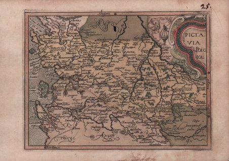
Pictavia Poictou
Payment methods
- PayPal
- Credit card
- Bank transfer
- Pubblica amministrazione
- Carta del Docente
Details
- Year of publication
- 1579
- Place of printing
- Colonia
- Size
- 200 X 150
- Engravers
- MATAL [METELLUS] Jan
Description
Carta geografica tratta dal rarissimo Itinerarium Europae Provinciae edito a Colonia tra il 1579 e il 1588. Conosciuto anche come Itinerarium Orbis Christiani, questo atlante fu pubblicato anonimamente a causa dei problemi politici e religiosi che caratterizzavano il periodo storico, come spesso succedeva aal'epoca per sfuggire alle persecuzioni cattoliche contro i protestanti. L'opera fa parte degli atlanti editi dalla cosidetta scuola Cartografica di Colonia, durata per circa mezzo secolo (1570-1620 ca.), e formata principalmente da rifugiati fiamminghi ed olandesi tra i quali spiccano lo stesso Matthaeus Quad e Frans Hogenberg, che ne fu il fondatore. Le mappe sono attribuite alcune a Jan Matal ed altre a Michael von Eitzing. Jan Matal o Metellus, francese di nascita ed attivo a Louvaine ed a Colonia, dove si rifugia prprio per sfuggire alle persecuzioni dei regnanti cattolici e dove muore nel 1597. Fu tra i maggiori cartografi del tempo e, insieme al Quad e al Hogenberg stesso, il principale esponente della scuola coloniese. Alcune delle mappe del Matal sono poi successivamente incluse nelle successive pubblicazioni postume, e recano il testo al verso. Dal punto di vista cartografico le mappe sono una derivazione e basate sulle carte pubblicate ad Anversa da Abraham Ortelius, per la prima volta nel 1570; le incisioni delle mappe sono invece attribuite a Frans Hogenberg. La grandissima rarità dell'opera, insieme alla scarsità di informazioni sulle opere "carbonare" edite a Colonia, contribuisce al fascino di questa importante mappa, caposaòdo di ogni collezione cartografica. Incisioni in rame, magnifica coloritura coeva, in buono stato di conservazione. Opera di incredible rarità, mancante in praticamente tutte le collezioni. Esemplare di primo stato, avanti il numero. Meurer Atlantes Colonienses Die Kolner Schule der Atlas Kartographie 1570-1610; Meurer IOC 8 Map from the very rare Initerarium Europae Provinciae, published in Cologne between 1579 and 1588. Also known as Itinerarium Orbis Christiani, this atlas was published anonymously due to the political and religious problems that characterized that particular period, i.e., the persecutions suffered by the Protestants who were threatened by the Catholics. The work belongs to the atlases published by the so called Cartographic school of Cologne, whose works were published along fifty years (1570-1620). The school was mainly made of Flemish and Dutch refugees among which Mattheaus Quad and Frans Hogenberg, the founder of the institution. The maps have been ascribed to Jan Matal and Michale von Eitzing. Jan Matal, or Metellus, was born in France and worked in Louvaine and Cologne, where he fled to escape the Catholic persecution and where he died in 1597. He was considered one of the greatest cartographers of his time and one of the most important artists of the school of Cologne, together with Quad and Hogenberg. some of his maps have been afterwards included in some posthumous works with the text on verso. From a cartographic point of view, the maps derive from those published by Abraham Ortelius in Antwerp in 1570; the engravings instead have been ascribed to Frans Hogenberg. The rarity of this work, together with the lack of information on the secret works published in Cologne confer a particular charm to this map, a bench mark for every collector. Copper engravings, magnificent contemporary colours, in very good condition. Extremely rare work, not present in any collection. Example in the first state, before the number was added. Meurer Atlantes Colonienses Die Kolner Schule der Atlas Kartographie 1570-1610; Meurer IOC 8 Cfr.