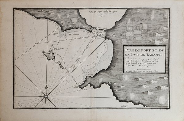
Plan du Port et de la Baye de Tarante
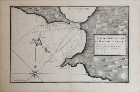
Plan du Port et de la Baye de Tarante
Payment methods
- PayPal
- Credit card
- Bank transfer
- Pubblica amministrazione
- Carta del Docente
Details
- Year of publication
- 1720
- Place of printing
- Marsiglia
- Size
- 465 X 305
- Engravers
- AYROUARD Jacques
- Inscription description
- NMM 206; Shirley, British Library, M.AYR-1a.; LC 7862. The Map Collector, Issue 24, p.49.
Description
Carta nautica tratta dal raro atlante nautico "Recueil de plusieurs Plans des Ports et Rades et de quelques Cartes particulières de la Mer Méditerranée, avec les figures des Terres remarquables pour les reconnoissances des Atterrages", edito tra il 1732 ed ll 1746.Jacques Ayrouard, idrografo francese, risulta attivo tra il 1730 ed il 1750; il raro atlante dei porti del Mediterraneo rimane la sua unica opera. Il lavoro di Ayrouard costituisce uno strumento fondamentale per la navigazione costiera, registrando suoni, ancoraggi e note di pilotaggio su rocce e scogliere e include una serie di profili costieri come ulteriore aiuto alla navigazione. Questo atlante nautico sarebbe stato successivamente disegnato da numerosi idrografi, in particolare William Heather che cita Ayrouard nel suo “New Mediterranean Pilot” del 1802. Ayrouard dedica il lavoro a Jean Frédérick Phélypeaux, conte di Maurepas, segretario della casa reale e ministro della marina in la corte di Luigi XV, che fu prominente nel tentativo di introdurre un approccio più scientifico agli affari navali fino a quando fu esiliato nel 1749 per aver scritto dispregiativi epigrammi sull'amante del re, Madame de Pompadour. Il Conseil de la Marine, per il quale questa opera sembra essere stata prodotta, era stato fondato nel 1720 come depositario centrale di mappe, piani, diari e memorie relative alla navigazione. Dell'idrografo Ayrouard, poco si sa oltre i brevi dettagli che dà sul titolo in cui si definisce "Royal pilot of the King's Galleys" e spiega che questi grafici sono stati preparati da lui in viaggi che ha intrapreso sulla costa, conducendo aggiungere ulteriori note di pilotaggio per l'ingresso sicuro in alcuni porti e strade ("avec les Remarques necessaires qu'il faut observer pour l'entrée à Certains Ports et autres Endroits"). Allo stesso modo, l'incisore di questi grafici superbamente dettagliati, Louis Corne, è noto a Tooley esclusivamente da questo lavoro. Incisione in rame, in ottimo stato di conservazione. Sea chart from the rare Atlas Recueil de Plusiers Plans des Ports et rades de la Mer Mediterranée, printed in between 1732 and 1746. Jacques Ayrouard, a French hydrographer, worked between 1730 and 1750; the rare Mediterranean harbours atlas is his sole work. Ayrouard's work forms a working "waggoner" for the coast, recording soundings, anchorages, and pilotage notes on rocks and reefs, and includes a series of coastal profiles as a further aid to navigation. This pilot would subsequently be drawn on by numerous hydrographers, most notably William Heather who cites Ayrouard in his New Mediterranean Pilot of 1802. Ayrouard dedicates the work to Jean Frédérick Phélypeaux, comte de Maurepas, secretary to the royal household and minister of the navy in the court of Louis XV, who was prominent in attempts to introduce a more scientific approach to naval affairs until he was exiled in 1749 for writing derogatory epigrams about the king's mistress, Madame de Pompadour. The Conseil de la Marine, for whom this work appears to have been produced, had been founded in 1720 as a central depository for maps, plans, journals, and memoirs relating to navigation. Of the hydrographer Ayrouard, little is known beyond the brief details he gives on the title where he describes himself as "Royal pilot of the King's Galleys," and explains that these charts were prepared by him on voyages that he undertook on the coast, leading him to add further pilotage notes for the safe entry into certain of the harbours and roads ("avec les Remarques necessaires qu'il faut observer pour l'entrée á Certains Ports et autres Endroits"). Similarly, the engraver of these superbly-detailed charts, Louis Corne, was known to Tooley solely from this work. It is possible that this was a local production, perhaps produced in Marseille, hydrographer and engraver brought together under the aegis of the Conseil de la Marine to produce this pilot for the benefit of visitinCopperplate, in excellent condition. Cfr. NMM 206; Shirley, British Library, M.AYR-1a.; LC 7862. The Map Collector, Issue 24, p.49.