Regionis qvae est circa Lodinvm…
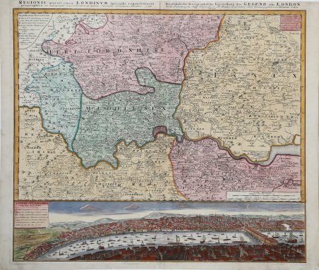
Regionis qvae est circa Lodinvm…
Payment methods
- PayPal
- Credit card
- Bank transfer
- Pubblica amministrazione
- Carta del Docente
Details
- Year of publication
- 1730
- Place of printing
- Norimberga
- Size
- 570 X 490
- Engravers
- HOMANN Eredi Johannes Baptiste
Description
Bella mappa della regione di Londra con sotto una veduta panoramica della città, edita dagli eredi della tipografia Homann. Johann Baptist Homann è stato un geografo e cartografo tedesco; nel 1702 fondò la sua casa editrice. Homann acquisì fama come uno dei principali cartografi tedeschi, e nel 1715 fu nominato geografo imperiale dall'imperatore Carlo VI. Nello stesso anno fu anche nominato membro dell'Accademia Prussiana delle Scienze a Berlino. Nel 1716 Homann pubblicò il suo capolavoro Grosser Atlas ueber die ganze Welt. Numerose mappe furono redatte in collaborazione con l'incisore Christoph Weigel. Homann morì a Norimberga nel 1724. Gli successe suo figlio Johann Christoph (1703-1730). L'azienda continuò dopo la sua morte come azienda degli eredi Homann, gestita da Johann Michael Franz e Johann Georg Ebersberger. Dopo successivi cambiamenti nella gestione, l'azienda si sciolse nel 1852. ' Incisione in rame, bella coloritura coeva con ritocchi, in buone condizioni. Extending north as far as Luton and south to Leatherhead this map encompasses much of modern London. Many of today's inner-city boroughs are outlying hamlets and villages on the eighteenth-century map. Occupying the lower quarter of the plate is a magnificent view of London and Westminster from Southwark, showing the tight curve of the Thames with identifiable buildings beyond. Homann's map of the London Environs is based on that produced in London by Thomas Bowles and he is credited in the title banner (with information in both Latin and German). Printed on thick paper (typical of the Nuremberg mapmakers) and with original colour, this is an extremely interesting London map. Johann Baptist Homann was a German geographer and cartographer; in 1702 he founded his own publishing house. Homann acquired renown as a leading German cartographer, and in 1715 was appointed Imperial Geographer by Emperor Charles VI. In the same year he was also named a member of the Prussian Academy of Sciences in Berlin. In 1716 Homann published his masterpiece Grosser Atlas ueber die ganze Welt; numerous maps were drawn up in cooperation with the engraver Christoph Weigel the Elder. Homann died in Nuremberg in 1724 and was succeeded by his son Johann Christoph (1703-1730). The company carried on upon his death as Homann heirs company, managed by Johann Michael Franz and Johann Georg Ebersberger. After subsequent changes in management the company folded in 1852. Cfr.