Rome & its environs from trigonometrical survey
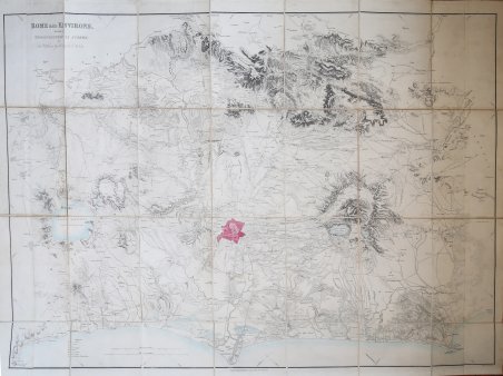
Rome & its environs from trigonometrical survey
Payment methods
- PayPal
- Credit card
- Bank transfer
- Pubblica amministrazione
- Carta del Docente
Details
- Year of publication
- 1834
- Place of printing
- Londra
- Size
- 1020 X 765
- Engravers
- GELL Sir William
Description
Carta geografica montata su tela a stacchi raffigurante Roma ed il suo circondario. La carta, come dichiarato nel titolo, si deve al rilevamento trigonometrico eseguito da Sir William Gell. Conservata nella sua rilegatura coeva. La mappa ha una leggera colorazione e Roma stessa è vivacemente colorata. Questa grande carta illustra la topografia di Roma e dei suoi dintorni, dal Lacus Sabatinus [Lago di Bracciano] a nord, fino a Norba a sud, e da Nerola a est alla costa tirrenica a ovest. La maggior parte dei toponimi più importanti sono identificati con i loro nomi classici. Include una “Explicatio” nell'angolo inferiore sinistro del disegno. Orientata con il nord a sinistra. I rilievi sono rappresentati da cunei e ombreggiature; Roma è dipinta in rosa. La carta fu completata nel 1822. Sebbene sia stata incisa per la prima volta a Roma, fu reincisa a Londra, con il sostegno finanziario della Società dei Dilettanti, e pubblicata con la Topography of Rome and its Vicinity in due volumi di William Gell nel 1834 e con la seconda edizione nel 1846. Sir William Gell FRS era un archeologo e illustratore classico britannico. Pubblicò illustrazioni topografiche di Troia e dell'area circostante nel 1804. Pubblicò anche illustrazioni che mostravano i risultati degli scavi archeologici a Pompei. In ottimo stato di conservazione. This large map details the topography of Rome and its environs, from Lacus Sabatinus [Lago di Bracciano] in the north to Norba in the south, and from Nerola in the east to the Tyrrhenian coastline in the west. Most of the larger features are identified by their Classical names. Includes an “Explicatio” in the lower left-hand corner of the design. Published by Saunders & Otley, London, 1834. Oriented with north to the left. Relief shown by hachures and shading; Rome is painted pink. The map was completed in 1822. Although first engraved in Rome, it was re-engraved in London, with financial support from the Society of Dilettanti, and published with Gell's two-volume Topography of Rome and its Vicinity in 1834 and with the 2nd ed. in 1846. Sir William Gell FRS (29 March 1777 – 4 February 1836) was a British classical archaeologist and illustrator. He published topographical illustrations of Troy and the surrounding area in 1804. He also published illustrations showing the results of archaeological digs at Pompeii. His best-known work is Pompeiana; the Topography, Edifices and Ornaments of Pompeii, published between 1817 and 1832. Cfr.