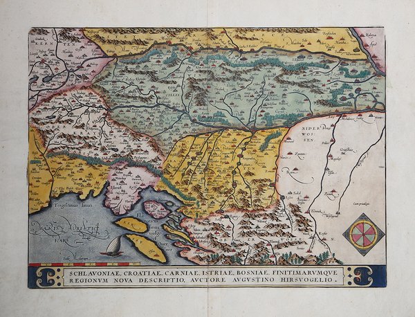
La mappa deriva dal prototipo di Augustin Hirschvogel (1552, 1565), che si è ispirato a Lazarus-Ziegler-Apian (Karrow 40/9, p. 299-300, Meurer p. 167). Carta tratta dal ' Theatrum Orbis Terrarum ' e che è considerato il primo vero “atlante” moderno. L’opera fu pubblicata in 7 lingue e 36 edizioni, per il quale – nel 1570 - Ortelius ottenne il ' privilegio, ovvero una sorta di diritto d'autore che impediva ad altri cartografi di pubblicare i propri lavori. Il ' Theatrum ' rappresentava il lavoro più avanzato del lavoro della descrizione cartografica. L’Ortelius vi raccolse il sapere geografico e cartografico del suo tempo, proponendo in 147 spettacolari tavole incise l’immagine più fedele del mondo allora conosciuto e, in alcune straordinarie “carte storiche”, regioni e itinerari tratti dalla letteratura, dalla mitologia, dalla tradizione. Ortelius fu anche il primo a citare le fonti, menzionando i nomi dei cartografi nel “catalogus auctorum”. Dal 1598 al 1612 le edizioni postume del ' Theatrum ' furono realizzate dal suo collaboratore Johannes Baptiste Vrients. Esemplare del secondo stato di tre descritto da Van den Broecke, dall'edizione latina del 1592. Incisione in rame, eccellente coloritura coeva, in ottimo stato di conservazione. Bibliografia Van den Broecke, Ortelius Maps, n. Ort 145 (Koeman/Meurer: 41, Karrow: 1/61, vdKrogtAN: 7601:31); Gròf (1979) "The Map Collector" 6:2-11; (1992) Gròf "Cartographica Hungarica" 1: 26-36. Fine and early map of former Yugoslavia after a map of Hirschvogel (1552-1565). Nice full color example of Ortelius' map of the region from centered on the Drag and Sava Rivers, extending south to the Adriatic, near Zara, and east to the Danube and West to Triest, Meron, Villach and Karlsberg. From the Theatrum Orbis Terrarum, the first modern atlas of the world. Cartographic sources: Hirschvogel (1552, 1565), who drew on Lazarus-Ziegler-Apian (Karrow 40/9, p. 299-300, Meurer p. 167). Map taken from the ' Theatrum Orbis Terrarum, which is considered the first true modern "Atlas". The work was published in 7 languages and 36 editions, for which - in 1570 - Ortelius obtained the privilege, a kind of copyright that prevented other cartographers from publishing his works. The ' Theatrum ' represented the most advanced work of cartographic description. Ortelius collected in it the geographical and cartographic knowledge of his time, proposing in 147 spectacular engraved plates the most faithful image of the world then known and, in some extraordinary "historical maps", regions and routes taken from literature, mythology, tradition. Ortelius was also the first to cite sources, mentioning the names of cartographers in the "catalogus auctorum". From 1598 to 1612 the posthumous editions of the ' Theatrum ' were made by his collaborator Johannes Baptiste Vrients. Example of the second state of 3 described by Van den Broecke, from the 1592 Latin edition. Copper engraving, contemporary coloring, in good condition. Bibliografia Van den Broecke, Ortelius Maps, n. Ort 145 (Koeman/Meurer: 41, Karrow: 1/61, vdKrogtAN: 7601:31); Gròf (1979) "The Map Collector" 6:2-11; (1992) Gròf "Cartographica Hungarica" 1: 26-36. Cfr.


 Find out how to use
 Find out how to use