Sclavonia Croatia, Bosnia & Dalmatiae Pars Maior
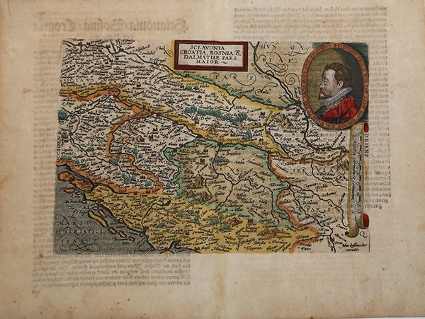
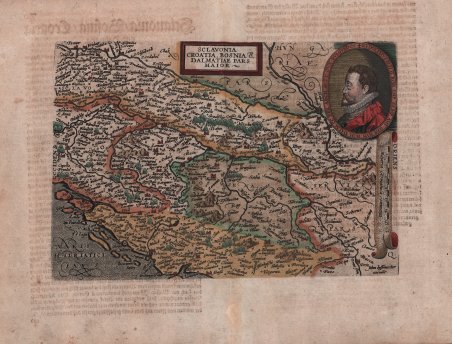
Sclavonia Croatia, Bosnia & Dalmatiae Pars Maior
Payment methods
- PayPal
- Credit card
- Bank transfer
- Pubblica amministrazione
- Carta del Docente
Details
- Year of publication
- 1592
- Place of printing
- Colonia
- Size
- 268 X 185
- Engravers
- QUAD Mattheus
Description
Mappa della regione dalla Slovenia alla Serbia, incisa da Johann Bussemacher e pubblicata da Quad.La mappa è centrata sulla Croazia e la Bosnia, e si estende a sud fino alla città di Spalato, sulla costa e ad est fino a Belgrado.Include un grande ritratto di Rodolfo II, l'Imperatore del Sacro Romano Impero (1576-1612), Re di Ungheria e Croazia (come Rudolf I, 1572-1608), Re di Boemia (1575-1608 / 1611) e Arciduca d'Austria (1576- 1608). Era un membro della casa degli Asburgo. Descritto da un noto contemporaneo come "il più grande mecenate d'arte del mondo". Bella e rara carta, tratta dall'opera di M. Quad ' Fasciculus Geographicus Complectens Praeciparum Totius orbis Regionum tabulas circiter centum. una cum earundum Enarrationibus ' edito a Colonia da J. Bussemacher, nel 1608. Matthaus Quad era un cartografo tedesco con sede a Colonia. La carta fu incisa da Johannes Bussemacher e apparve in diverse opere geografiche pubblicate da Quad e Bussemacher alla fine del XVI e all'inizio del XVII secolo. Matthias Quad (1557-1613), editore di carte geografiche con sede a Colonia, fu formato nei Paesi Bassi da Johannes van Doetecum, che lavorava anche con i De Jode. Quad utilizzò molte mappe di De Jode come base a cui aggiunse informazioni e decorazioni. Nel 1592 Quad pubblicò un atlante dell'Europa con 38 mappe. Nel 1594 lo ampliò a 50 mappe. Nel 1600 ampliò ulteriormente la collezione di mappe, questa volta fino a 82, e chiamò l'atlante ' Geographisch Handtbuch. Tutti e tre gli atlanti erano di piccole dimensioni, il che consentiva loro di competere come alternative più economiche ai grandi atlanti di Ortelius, Mercatore e De Jode. Quad pubblicò un altro atlante, nel 1608, con 86 mappe, il ' Fascilus Geographicus. Acquaforte, finemente colorata a mano, in ottimo stato di conservazione. Scarce early map of the region from Slovenia to Serbia, engraved by Johann Bussemacher and published by Quad.The map is centered on Croatia and Bosnia Herzogovina, extending south to Split on the coastline and east to Belgrade.Includes a large portait of Rudolf II, the Holy Roman Emperor (1576-1612), King of Hungary and Croatia (as Rudolf I, 1572-1608), King of Bohemia (1575-1608/1611) and Archduke of Austria (1576-1608). He was a member of the House of Habsburg. Described by a noted contemporary as "the greatest art patron in the world". From Fasciculus ' Geographicus Complectens Praeciparum Totius orbis Regionum tabulas circiter centum. una cum earundum Enarrationibus, Cologne, J. Bussemacher, 1608. Matthaus Quad was a German cartographer based in Cologne. The map was engraved by Johannes Bussemacher and appeared in several Geographical works published by Quad and Bussemacher at the end of the 16th and beginning of the 17th century. Matthias Quad (1557-1613), a map publisher based in Cologne, was trained in the Netherlands by Johannes van Doetecum, who also worked with the De Jodes. Quad used many De Jode maps as a base to which he added additional information and decorations. Quad was best known for his atlases, which were part of the first boom in atlases best characterized by Abraham Ortelius’ Theatrum Orbis Terrarum. In 1592, Quad released an atlas of Europe that had 38 maps. He expanded it in 1594 to 50 maps. In 1600, he expanded the collection of maps further still, this time to 82 maps, and called the atlas, Geographisch Handtbuch. All three were small in size, allowing them to compete as cheaper alternatives to the larger atlases of Ortelius, Mercator, and the De Jodes. Quad released one other atlas, in 1608, with 86 maps, the ' Fascilus Geographicus. Etching with fine later hand colour, good condition. Cfr.